- Who We Are
- What We Do
- Our Issues
- Our Projects
- Sprawl Retrofit
- Highways to Boulevards
- CNU/ITE Manual
- Health Districts
- The Project for Code Reform
- Lean Urbanism
- LEED for Neighborhood Development
- Missing Middle Housing
- Small-Scale Developers & Builders
- Emergency Response
- HUD HOPE VI
- Rainwater in Context
- Street Networks
- HUD Finance Reform
- Affordable Neighborhoods
- Autonomous Vehicles
- Legacy Projects
- Build Great Places
- Education & Trainings
- Charter Awards
- Annual Congress
- Athena Medals
- Resources
- Get Involved
- Donate
- Membership
- Public Square


History and Context
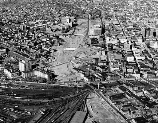
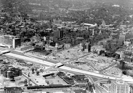
Route 34 in New Haven was originally planned in the 1940s to serve as a connection through the Lower Naugatuck Valley. The process of aquiring the necessary land began In the 1950's and resulted in 880 displaced families, 350 demolished buildings, and cutting off the downtown area from several neighborhoods, Union Station, and Yale School of Medicine. The Connector reduced the connectivity of the neighborhood street network and damaged the economic vitality of nearby businesses. The original plan was to extend the road an additional 10 miles, but that long section faced neighborhood opposition and was never constructed. Work on the route ended in the 1970's before its full completion, resulting in many people ironically referring to it with its original nickname: the Oak Street Connector.
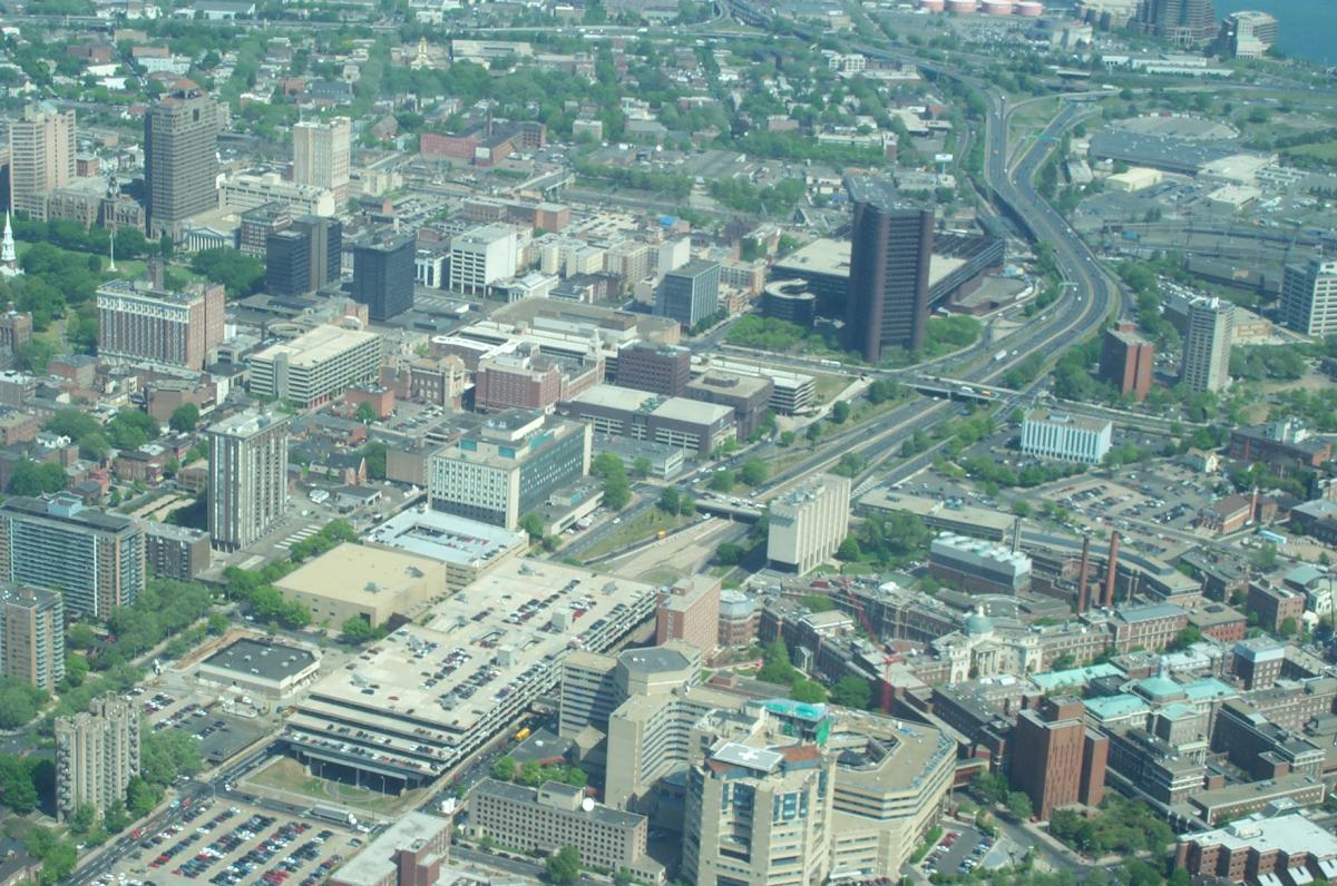
Route 34 begins at the junction of Interstates 95 and 91 and extends into downtown New Haven for 1.1 miles before dropping below grade at College Street and continuing as a pair of one-way streets. Route 34 carries 73,900 vehicles on the route per day. The Connector, occupies 26 acres of land between downtown and the adjacent neighborhood.
Proposal
In 2002, the State of Connecticut sold the land that had been set aside for the extension of the Oak Street Connector. In 2005, with the completion of Pfizer Pharmaceutical's research facility in the former planned right-of-way, the City of New Haven and local civic groups began calling for the replacement of the Oak Street Connector with a four-lane boulevard. A concept plan identified ten acres of vacant land to redevelop and two street connections to restore, along with a larger surrounding area to be revitalized. New Haven's Mayor, John DeStefano, Jr. included the removal of the Connector in Future Framework 2008 as an urban infill strategy. The Tri-State Transportation Campaign and the Urban Design League of New Haven are actively campaigning for the replacement of the depressed and paired one-way sections of Route 34 with walkable, pedestrian-friendly streets and blocks.
In early 2010, Mayor DeStefano announced the initial phases of the removal of Route 34 starting with 100 College Street, in his address to the City. New Haven was awarded a TIGER II grant with the Connecticut Department of Transportation (CONNDOT) to prepare an Environmental Impact Statement (EIS). Controversy continues over the scale of the new surface street. Residents and activists have pushed for greater pedestrian safeguards and to reduce the number of lanes in the current Downtown Crossing plan.
Completed Plans
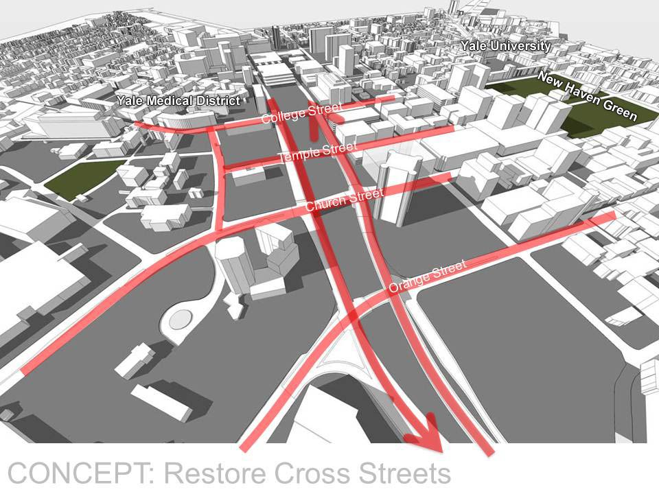
The plan to replace Route 34 is called Downtown Crossing and aims to develop a livable, walkable community while providing local and regional connectivity. Its goal is to reclaim 10 acres of land for residential, retail and health care facilities development and create a series of new city streets and boulevards through three phases.
Phases 1, 2, and 3 of Downtown Crossing have been completed. The final phase of Downtown Crossing, Phase 4, will connect Temple Street to Congress Avenue. Phase 4 will include the construction of the bridge connecting Temple Street to Congress Avenue. The bridge will be designed to accommodate pedestrians and bicyclists as well as slower speed motor vehicle traffic. Phase 4 is anticipated for construction in 2025-2027.