- Who We Are
- What We Do
- Our Issues
- Our Projects
- Sprawl Retrofit
- Highways to Boulevards
- CNU/ITE Manual
- Health Districts
- The Project for Code Reform
- Lean Urbanism
- LEED for Neighborhood Development
- Missing Middle Housing
- Small-Scale Developers & Builders
- Emergency Response
- HUD HOPE VI
- Rainwater in Context
- Street Networks
- HUD Finance Reform
- Affordable Neighborhoods
- Autonomous Vehicles
- Legacy Projects
- Build Great Places
- Education & Trainings
- Charter Awards
- Annual Congress
- Athena Medals
- Resources
- Get Involved
- Donate
- Membership
- Public Square


History and Context
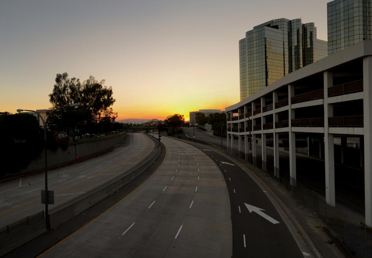
Connecting the Interstate 710 Freeway via Shoemaker Bridge to Alamitos Avenue on the eastern edge of the Downtown, Shoreline Drive takes on many different characters, reflecting its various eras of expansion. Historically once part of the Interstate 710 Freeway, the asset has been largely owned by the City of Long Beach since the nineties. The first 2/3 mile length of Shoreline Drive was developed at the northwest corner of Downtown, extending the I-710 Freeway into the commercial core of Long Beach, terminating at West Ocean Boulevard adjacent to the Los Angeles River. The transportation project doubled as an urban renewal project typical across the nation after the Second World War as construction of the initial length was preceded by the obliteration of a dozen city blocks of homes, apartments, and businesses.
The next half-mile length extended to the south and east, through the former Magnolia Beach area, also more colorfully known as the “Jungle”. The neighborhood was one of the closest civilian populations to the Navy installations on Terminal Island. In the fifties, the city considered replacing large portions of the area with surface parking and ship landings to sterilize the area before ultimately extending Shoreline Drive through it. Now this length of Shoreline Drive is flanked by almost a dozen crystalline office towers. Shoreline Drive take a distinctly more urban character as it is a concrete canyon served by on and off-ramps with overpasses connecting Ocean Boulevard to the Catalina Landing area to the south.
Originally, the urban freeway configuration of Shoreline Drive extended another third of a mile to South Pine Avenue with a massive interchange at Queensway Bridge. That portion was de-engineered in the eighties; with flyovers and off-ramps removed in exchange for new sidewalks and bike paths. Now the last mile portion of Shoreline Drive provides the foundation for the Long Beach Grand Prix racetrack, the largest annual event in the city. Originally part of the Pacific Ocean, the Downtown waterfront was extended south from Seaside Way as portions of the Port of Long Beach were expanded through land reclamation. Shoreline Drive currently severs Downtown Long Beach from the Los Angeles River and Pacific Ocean while leaving a wake of destruction of former neighborhoods and natural habitats.
Proposal
At the 2012 Transportation Summit held in Long Beach, California, Highways-to-Boulevards initiative members and CNU members gathered to present ideas and work towards reforming transportation standards that obstruct urbanism. The initiative met as a small working group to address barriers in the standard transportation planning process as well as consider boulevard retrofit recommendations for Shoreline Drive located in Long Beach, California. Working group members considered the age and design of the infrastructure, redevelopment potential, potential cost savings, ability to improve both overall mobility and local access and community support. The following report details the history of Shoreline Drive, precedents applicable to Shoreline Drive, and preliminary considerations and guiding principles for Shoreline Drive.
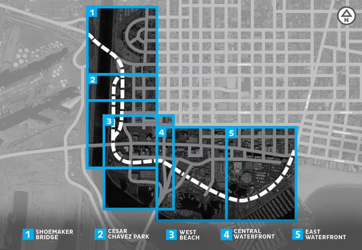
Long Beach nonprofit design studio, City Fabrick provided the Shoreline Drive background for the CNU Transportation Summit and subsequently developed the Shoreline Drive Case Study into Highways to Boulevard: Reimagining Shoreline Drive. The plan attempts to create a street network that supports community and place while sustaining the various different events [including Grand Prix and Pride utilize the roadway] and many major waterfront destinations including the Aquarium of the Pacific, Convention Center and Performing Arts Center. Overall the plan calls for transforming Shoreline Drive into a tree-lined boulevard with active mobility facilities and community amenities.
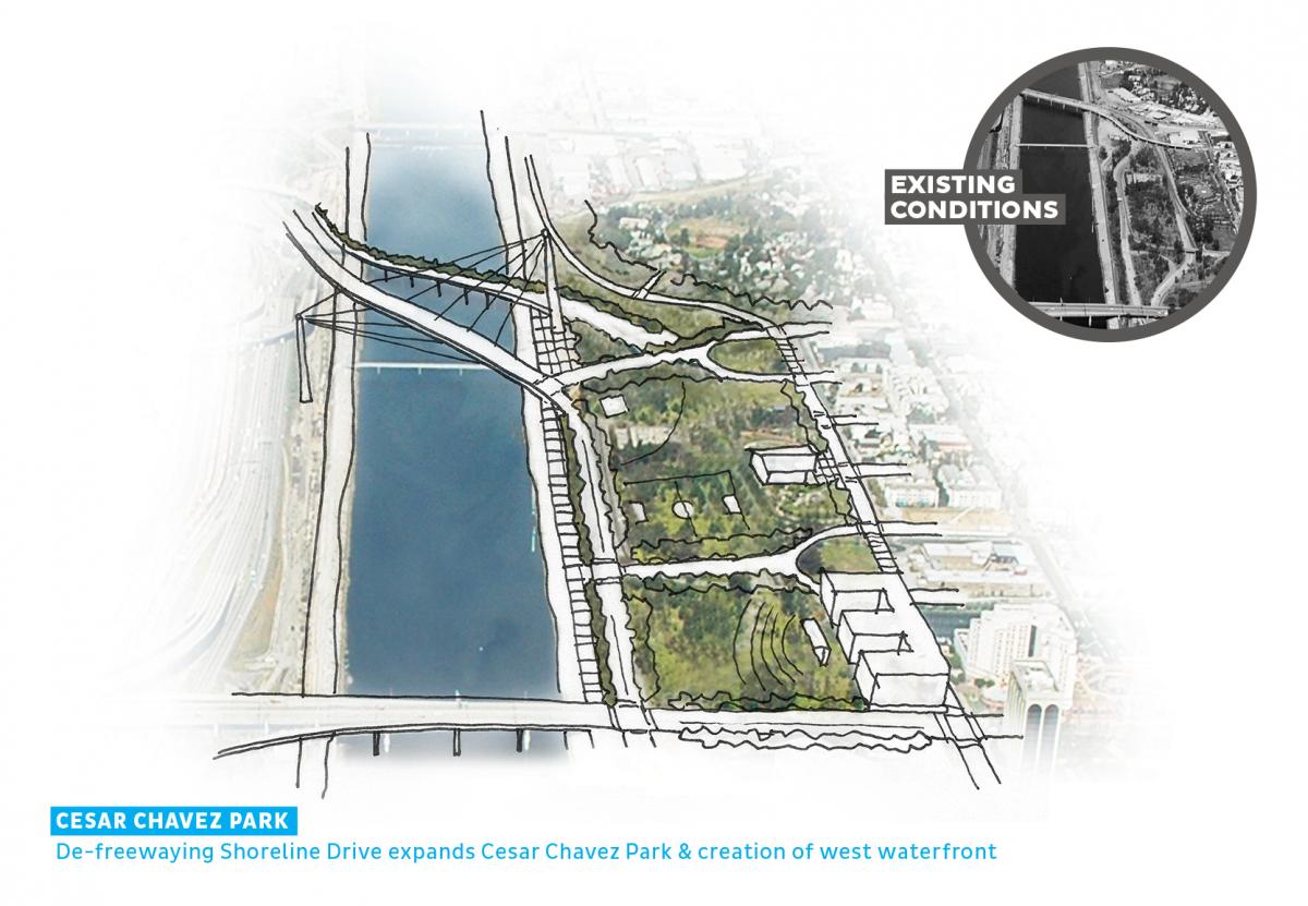
Extending the original Downtown streets into the waterfront to Shoreline Drive will better connect residents, visitors and workers to the Pacific Ocean and Los Angeles River while dispersing traffic throughout the street network. New public open space is created by expanding Cesar Chavez Park and the Marina Green while the south waterfront is extended along the western edge of the Downtown. Other surplus land and under-utilized parcels are better positioned for public and private development with new frontages and improved access. Overall, the plan identifies goals and strategies that transforms single-mode infrastructure into a multimodal corridor with additional benefits for improving community health.
Current Plans
The City of Long Beach is currently developing plans to replace the Shoemaker Bridge and mile of Shoreline Drive leading up the bridge as an early action project for the I-710 Freeway expansion. Initial designs called for consolidating north and southbound portions of the freeway but largely replacing in the place the interchanges and on/off-ramps, but have subsequently considered alternatives that remove the grade separations. City staff will be selecting a consultant to develop the final plans for replacing the bridge and reconfiguring Shoreline Drive and adjacent infrastructure.
In spring 2020, the City Council voted to reconstruct the Shoemaker Bridge with construction expected to begin in early 2023. The new bridge will include a roundabout on its east side and the project will also realign streets to add nearly four acres of park space to Cesar Chavez Park, which lies on the east side of Shoreline Drive and stretches from Ocean Boulevard north to Sixth Street.
Get Involved
Contact CityFabrick, a nonprofit urban design studio dedicated to improving the physical environment of Long Beach through design, planning, policy and engagement.