- Who We Are
- What We Do
- Our Issues
- Our Projects
- Sprawl Retrofit
- Highways to Boulevards
- CNU/ITE Manual
- Health Districts
- The Project for Code Reform
- Lean Urbanism
- LEED for Neighborhood Development
- Missing Middle Housing
- Small-Scale Developers & Builders
- Emergency Response
- HUD HOPE VI
- Rainwater in Context
- Street Networks
- HUD Finance Reform
- Affordable Neighborhoods
- Autonomous Vehicles
- Legacy Projects
- Build Great Places
- Education & Trainings
- Charter Awards
- Annual Congress
- Athena Medals
- Resources
- Get Involved
- Donate
- Membership
- Public Square


History and Context
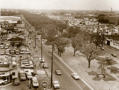
Settled in the heart of New Orleans, a once thriving commercial district filled with cafes and restaurants, grocers, music venues, and other businesses sustaining daily neighborhood activities lined the streets of North Claiborne Avenue. Giant oak trees and greenery loomed in the middle of the boulevard, creating a vibrant, pedestrian-friendly atmosphere, acting as a congregation center connecting one side of the town to the other. The area became so integral to the surrounding neighborhoods of Tulane/Gravier, Tremé/Lafitte and the 7th Ward that some of the earliest Mardis Gras parades ended with large celebrations up and down North Claiborne Avenue. It was the ultimate display of public space.
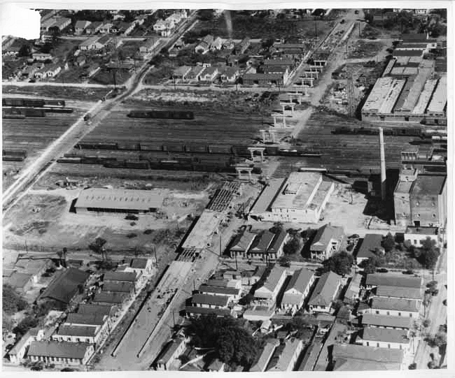
Despite the success of the commercial sector, the areas surrounding North Claiborne Avenue experienced decentralization and disinvestment similar to other places during the post-WW II era. Yet the North Claiborne district received something in addition to its declining atmosphere: the Interstate-10 Claiborne Expressway, a massive, elevated highway bisecting the town that further devastated the existing structure, character, and vitality of many surrounding neighborhoods.
In the 1950s, the Federal government strongly incentivized urban freeway construction by covering 90% of the costs. Interstate-10’s construction commenced above North Claiborne Avenue at this time to increase access in the Central Business District. Robert Moses proposed the Vieux Carré Riverfront Expressway through the French Quarter following the completion of Interstate-10 to enhance the accessibility of the area. The French Quarter proposal was stopped by preservationists after a long-fought battle persuading the federal government to withhold funding. Unfortunately, citizens located along North Claiborne Avenue, some of the oldest African American neighborhoods in the country, did not have the resources or political power to prevent the I-10/Claiborne Expressway from moving forward.
The oak trees lining Claiborne Avenue were removed (most supposedly relocated to other parts of town), along with clearing 500 homes to prepare for the highway that opened in 1968, permanently changing the once actively green streetscape with concrete. Soon afterward, the business district quickly declined and the quality of life of neighborhood residents dropped as their neighborhood center disintegrated.
Proposal
Following Hurricane Katrina and the subsequent rebuilding efforts, the call became prominent to rethink the I-10 elevated expressway's role for the North Claiborne Corridor and City at large. Already at or beyond its designed lifespan of 40 years, the structure also endured damage sustained from the hurricane, making a highway removal decision vital and urgent. The community design charrettes held by the United New Orleans Plan and NOLA Master Plan groups encouraged residents to voice their hopes of what they wish to achieve within their community. Both plans called for traffic and environmental impact studies and feasibility reports of removing the inner-city portion of the Interstate-10 elevated expressway. The findings from these products would provide feasibility and cost estimates for various alternatives within the corridor. Particularly along North Claiborne Avenue, residents were hoping to unveil the potential hidden behind the concrete pillars of I-10.
Current Plans
In 2012 the Department of Housing and Urban Development (HUD) and the U.S. Department of Transportation (USDOT) jointly awarded a $2 million grant-with matching funds put forth by the City of New Orleans and local non-profits-to engage stakeholders in the area to develop three alternative for the Claiborne Corridor. The Livable Claiborne Communities study concluded its final meeting in October 2013, and outlines the following scenarios:
Scenario 1
- I-10 Expressway remains but two select ramps are removed
- N. Rampart Streetcar is completed running parallel to expressway
- Neighborhood is linked with continuous bus service along Claiborne Ave.
- 3,500 new household and roughly 600 new jobs come to the LCC area (largely at proposed LSU University Medical Center and VA Hospitals)
Scenario 2
- I-10 Expressway remains but three select ramps are removed
- N. Rampart Streetcar is completed running parallel to expressway
- Neighborhood is linked with continuous bus service along Claiborne Ave. and a streetcar from Poydras St. to Elysian Fields Ave.
- 4,500 new household and roughly 1,070 new jobs come to the LCC area
Scenario 3a
- I-10 Expressway is removed from Tulane Ave. to St. Bernard Ave.
- N. Rampart Streetcar is completed running parallel to expressway
- Neighborhood is linked with continuous bus service along Claiborne Ave.
- 6,000 new household and roughly 1,270 new jobs come to the LCC area (largely at proposed LSU University Medical Center and VA Hospitals)
Scenario 3b
- I-10 Expressway is removed from Tulane Ave. to St. Bernard Ave., as is the entire downtown interchange system)
- N. Rampart Streetcar is completed running parallel to expressway)
- Neighborhood is linked with continuous bus service along Claiborne Ave. )
- 6,000 new household and roughly 2,470 new jobs come to the LCC area (largely at proposed LSU University Medical Center and VA Hospitals)
Construction costs increase with each respective option, particular increasing from Scenario 3a to 3b. However estimated tax revenues greatly increase with each option as well.
As residents and government officials look to restore the city, new urbanists have urged that the historic character should form the basis of rebuilding efforts, including the restoration of the street network. With the removal of I-10 over North Claiborne Avenue, the city will experience a reconnection with surrounding neighborhoods, a rise in economic development with increased use of previously underutilized connector streets, and most importantly, the reinstatement of the oak tree lined boulevard that the street was so well known for, replenishing the cultural value and working to correct the attempted urban renewal phase of the 1960s.
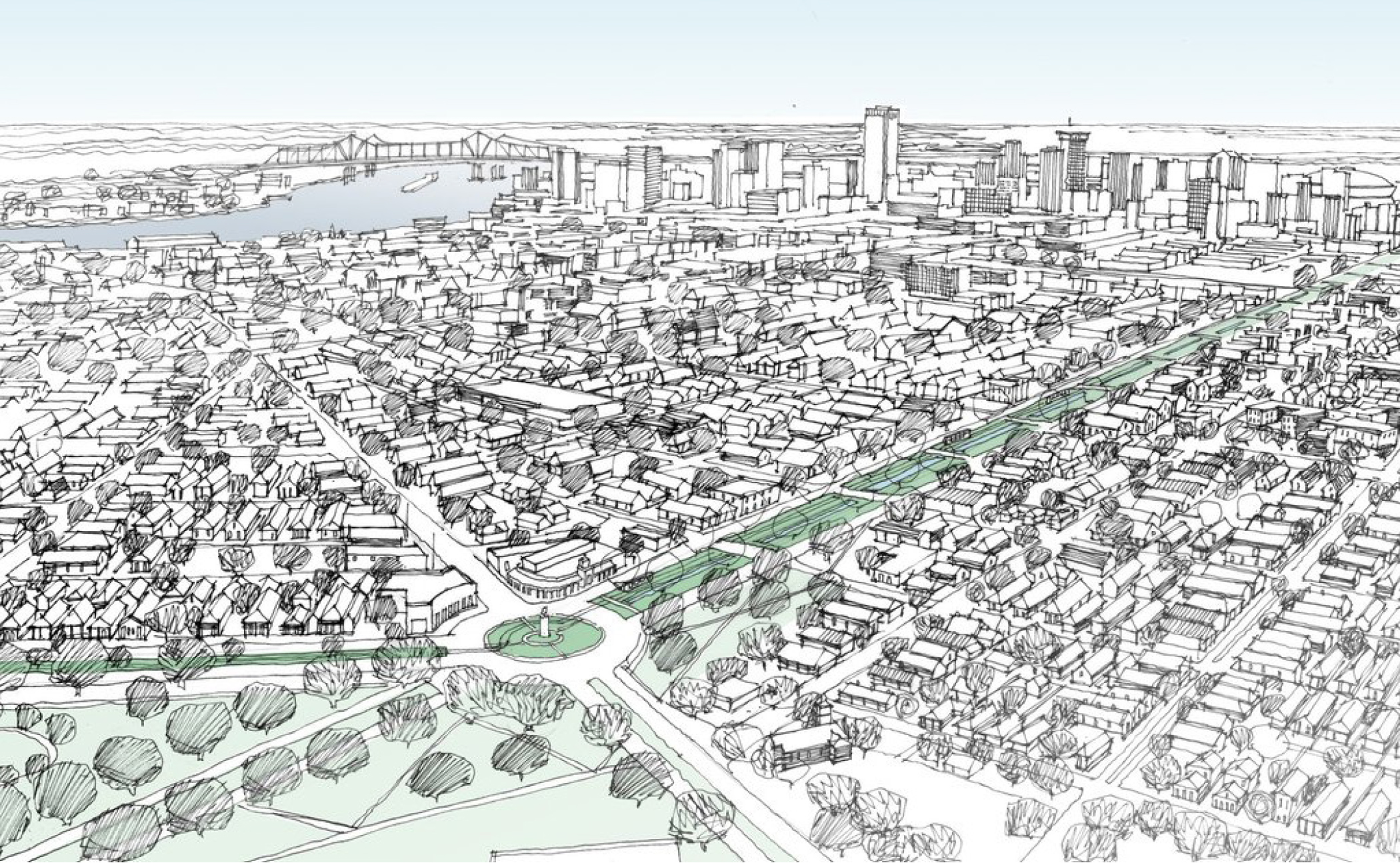
Since 2017, the Claiborne Avenue Alliance—a coalition of residents, property owners, and business leaders dedicated to the thoughtful development of the Claiborne corridor—has led a renewed effort to remove the expressway and rebuild the avenue. The group has set about to document the negative effects the freeway has on adjacent neighborhoods, from severe pollution to the creation of a food desert. The group has also emphasized the positive potential outcomes of removing the freeway. A restored Claiborne Avenue would attract new businesses and jobs to this once-vibrant commercial corridor, as many of the vacant lots adjacent to the highway become redeveloped. All told, nearly 50 acres of land would be reclaimed from the highway’s shadow. The Claiborne Avenue Alliance advocates that the city devote a large portion of this reclaimed land to the creation of affordable housing and commercial spaces. This would address significant community concerns: While many Tremé residents want to see Claiborne Avenue restored, they fear that such an improvement could price them out of the neighborhood.
Political traction for the expressway’s removal is again on the rise. Recently, Mayor LaToya Cantrell sent her staff to tour the former site of the Embarcadero Freeway in San Francisco, one of the first elevated freeways in the United States to be converted into a boulevard. City Council president Jason Williams also joined them.
Longtime Tremé residents have made sure to perpetuate conversations around the highway’s removal and the restoration of Claiborne Avenue. Their persistence stems from memories of a great avenue, once an economic and cultural asset for the community, and a vision for the future that provides a similar place for generations to come.