- Who We Are
- What We Do
- Our Issues
- Our Projects
- Sprawl Retrofit
- Highways to Boulevards
- CNU/ITE Manual
- Health Districts
- The Project for Code Reform
- Lean Urbanism
- LEED for Neighborhood Development
- Missing Middle Housing
- Small-Scale Developers & Builders
- Emergency Response
- HUD HOPE VI
- Rainwater in Context
- Street Networks
- HUD Finance Reform
- Affordable Neighborhoods
- Autonomous Vehicles
- Legacy Projects
- Build Great Places
- Education & Trainings
- Charter Awards
- Annual Congress
- Athena Medals
- Resources
- Get Involved
- Donate
- Membership
- Public Square


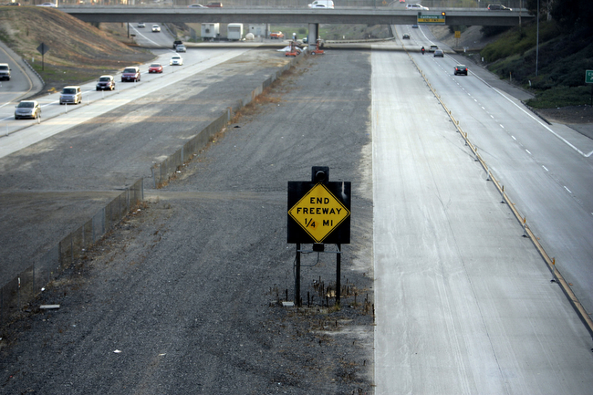
The 2014 Freeways Without Futures Report lists the top opportunities in North America for replacing aging urban highways with boulevards or avenues that connect to the networks of streets. They are presented in no particular order of rank. As in previous reports, the criteria for the 2014 list is based on a number of factors: the age and design of structures, redevelopment potential, potential cost savings, ability to improve both overall mobility and local access, existence of pending infrastructure decisions, and community support.
I-10/Claiborne Overpass, New Orleans
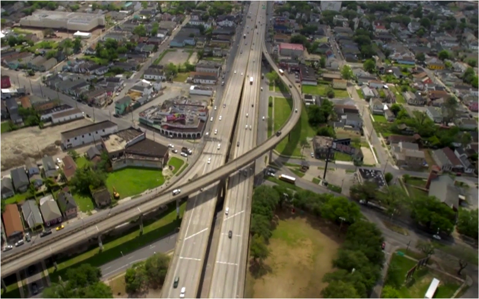
In the 1960s, elevated Interstate 10 (I-10) was built directly over Claiborne Avenue, a thriving commercial strip in the neighborhoods of Tulane/Gravier, Tremé, Lafitte, and the 7th Ward. In 1966, the oak trees that lined the avenue were destroyed or, in some cases, transplanted to other parts of the city and were replaced by concrete columns to support the highway. Some 500 homes, businesses and other buildings were removed to make room for the new highway. As a result of the highway construction, Tremé—one of the first free African-American communities, and once one of the wealthiest — was left physically divided and socially marred
Following the devastation of Hurricane Katrina in 2005 and the subsequent rebuilding efforts, there was an increasing call to rethink I-10’s role in the North Claiborne Corridor, especially in light of the age of the structure and the damaged sustained by the storm. The Unified New Orleans Plan (UNOP) a comprehensive planning process to coordinate recovery and rebuilding after Hurricane Katrina, suggested that the removal of I-10 "would have considerable positive impacts by re-connecting neighborhoods and restoring what was once a beautiful tree-lined avenue. Traffic redistribution provides economic development benefits to a corridor ripe for more volume." The UNOP predicted that with the full removal of two miles of the elevated I-10, the city could reclaim 35 to 40 city blocks that would no longer be devalued by the freeway as well as 20 to 25 blocks of open space.
In 2012, an encouraging federal policy shift occurred. The Department of Housing and Urban Development (HUD) and the U.S. Department of Transportation (USDOT) jointly awarded a $2 million grant – with matching funds put forth by the City of New Orleans and local non-profits — to engage stakeholders in the study area to develop three alternatives for the Claiborne Corridor. After more than a year of public engagement, The Livable Claiborne Communitiesstudy concluded its final meeting in October 2013. The study outlines four scenarios for the future of the Claiborne corridor, including removing the elevated expressway from Tulane Ave to St. Bernard, redistributing traffic on local streets, taming and removing of expansive interchanges, and creating more livable conditions for neighborhood residents. [Image: Still from Claiborne Avenue: Past, Present and Future]
I-81, Syracuse New York City
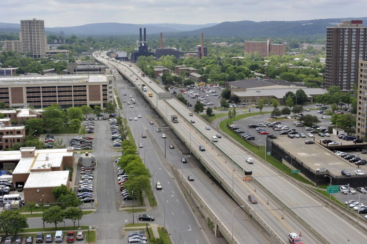
The construction of Interstate 81 in Syracuse came with the forced displacement of nearly 1,300 residents from the city's 15th Ward. It devastated a historic black community, severing the social fabric of the community and razing swaths of buildings, and with them, affordable housing options. Neighborhood deterioration, a glut of surface parking lots, and citywide population loss followed.
Today, the average annual daily traffic on I-81 ranges from about 43,000 to 90,000 vehicles per day as it runs just east of downtown and connects with I-690. As with many structures from the 1960s, many portions, including the 1.4-mile elevated section in downtown Syracuse known as "the Viaduct," are near the end of their design life.
For years, Syracuse Common Councilor Van Robinson has been vocal about the benefits of removing the elevated interstate. Syracuse Mayor Stephanie Minor is also in favor of teardown. Leading figures from Syracuse University and Upstate Medical University, who see I-81 as an eyesore and impediment to the growth of their respective institutions, have expressed support for removal.
The Syracuse Metropolitan Transportation Council and the New York State Department of Transportation (NYSDOT) co-led a multi-year study to review potential alternatives and analyze traffic with input from the public, called the I-81 Challenge. Additionally, the Onondaga Citizens League conducted a study titled "Rethinking I-81," which focuses on the social, economic, and cultural effects of possible alternatives. Despite pushback from opponents, several other Syracuse organizations have joined the teardown coalition to lobby state officials to consider replacing I-81 with something that returns value to the city of Syracuse. Supporters have suggested nearby I-481 could act as the main carrier for through-traffic, while elevated I-81 would be replaced with an urban boulevard that would reconnect downtown neighborhoods, be less costly to maintain, and increase economic activity along the corridor.
In 2013, the state DOT hired Parsons Transportation Group to study alternatives and address the long-term future of the I-81 corridor. The process is moving into environmental review and the preliminary design stage; the viaduct portion of the total 12-mile study area will be made a priority. Currently six alternatives are being considered. NYSDOT Commissioner Joan McDonald has publicly stated her personal opinion that "it would be great for the community to bring it down." [Image: Syracuse.com]
Gardiner Expressway, Toronto
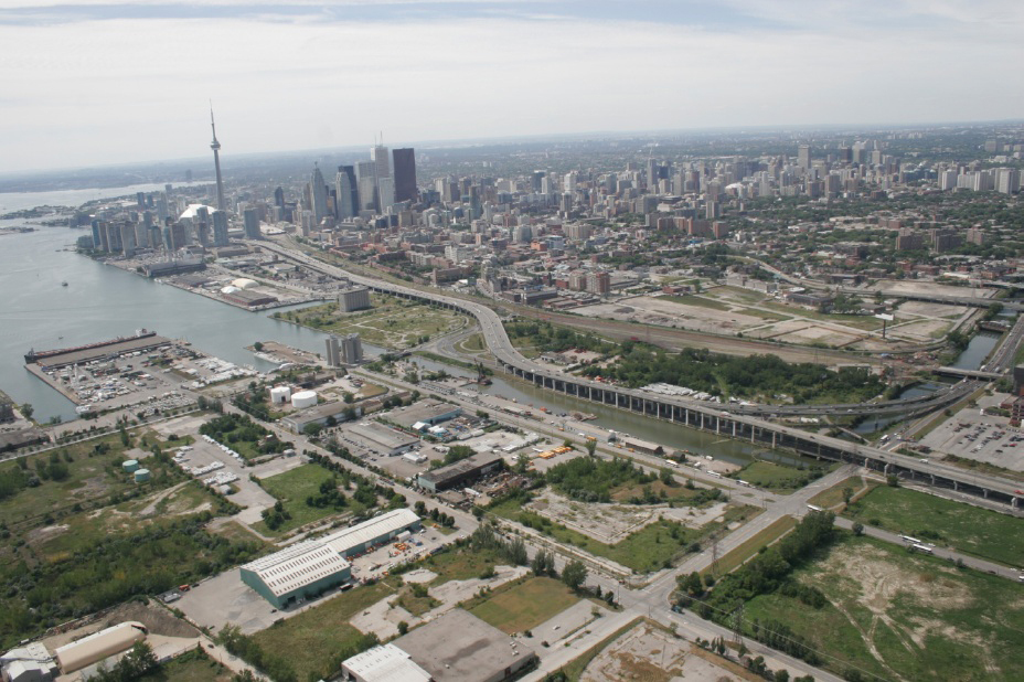
Built between 1955 and 1966 by the Ministry of Transportation of Toronto (MTO), Toronto's Frederick G. Gardiner Expressway is a major east-west thoroughfare that connects downtown Toronto to its western suburbs. The Gardiner's eastern elevated eight lanes separate the city from its Lake Ontario waterfront. What was originally built to accommodate much less daily traffic, the Gardiner, east of Jarvis Steet, now carries 120,000 vehicles daily and costs around $10 million annually in repairs.
For years, citizens of Toronto have called for the removal of the elevated expressway as it runs from downtown eastward. And they've had some success: a far eastern portion of the freeway was successfully removed in 1999. It was originally intended to connect downtown to the suburb of Scarborough, but a citizens' revolt stopped the freeway's progress and left only a 1.3 km stub. The result was a beautiful linear park that includes bikeways and public art installations. However, much of the eastern portion remains.
Just recently, the City of Toronto and WATERFRONToronto finished work on the Gardiner Expressway & Lake Shore Boulevard Reconfiguration Environmental Assessment & Urban Design Study, which will help determine the future of the 2.4 km elevated section of the expressway from Jarvis Street to just east of the Dan Valley Parkway abutting Lake Ontario. Four main approaches are being considered for the Gardiner: maintaining ($235m), removing ($240m-$360m), improving ($420m-$630m), or replacing ($610m-$910m). In contrast, the Toronto City Council already approved a budget – between 2013 and 2022 – for a nearly $500 million rehabilitation of the downtown expressway. Interestingly, the maintenance work will move west to east down the freeway – perhaps in anticipation of the removal campaign's success.
Former Toronto Mayor David Miller believes tearing down the Gardiner to be "the most practical approach and offers the greatest public benefits." Deputy City Manager John Livey stated that a preferred option, or possibly a shortlist, will be presented to city council in early February. Engineering on a final project will begin in 2018 at the earliest.
[Image: ArchDaily]
Route 5/Skyway, Buffalo
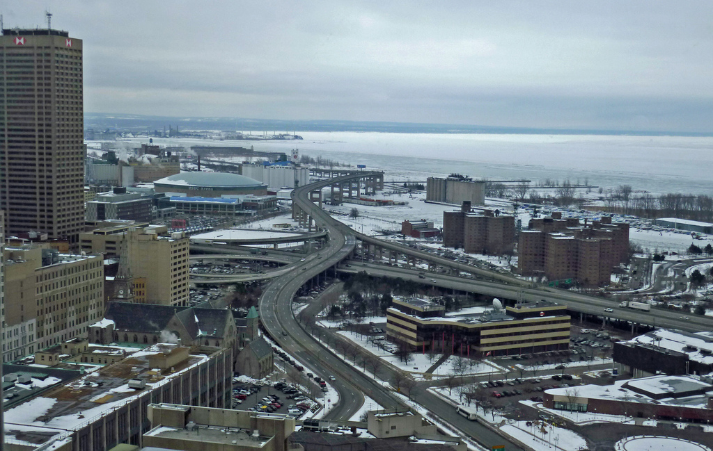
Completed in 1956, this 1.4-mile long, 110-foot tall limited-access Skyway Bridge begins at the Inner Harbor downtown, crosses the Buffalo River and touches down as Route 5 in the Outer Harbor. Route 5 continues for another 2.6 miles as a limited-access expressway built on an embankment of slag. It mars public views of the adjacent waterfront, depreciates land values and hinders both public and private redevelopment efforts. The highway's oddly configured exit ramps lead to a confusing series of one-way streets that further hinder access to the waterfront, There is no pedestrian access between downtown and the Outer Harbor. A total of 41,500 vehicles per day travel along this blighted corridor.
A coalition of citizens and civic organizations, including members of the Buffalo Common Council, New York State Assemblyman Michael Kearns, and CNU continue to call for the Skyway to come down and the replacement of urban sections of Route 5 through Buffalo with a surface boulevard. Removal advocates tout the boulevard and connecting urban street grids' environmental and economic development benefits for downtown and waterfront redevelopment. The DOT rates the Skyway bridge as "fracture critical" while the Federal Highway Administration classifies the bridge as "functionally obsolete." It is likely to cost more than $50 million to maintain over the next two decades.
In 2013, Commissioner of the New York State Department of Transportation Joan McDonald directed her office to conduct a plausibility review of the route. NY Senator Tim Kennedy, joining a chorus of fellow lawmakers demanding the Skyway come down, has insisted that the DOT make these findings public, evoking removal as a way to further catalyze waterfront development in downtown Buffalo. As of January 2014, the results of the review have not been released. [Image: Payton Chung via flickr]
Inner Loop, Rochester New York
In the early 1950's, when construction began on Rochester's Inner Loop Highway, the city's population was about 330,000. Today, Rochester is a shrunken city of about 210,000, with 50,000 jobs in its downtown core (in a metropolitan area of over 1,000,000).
The 2.68-mile Inner Loop was built for a more populous city in an era of planning that was dominated by highway engineering and ample federal subsidy for single-use expressways. Like most beltways fully built out in the mid-20th century, the Inner Loop completely encircles Rochester's central business district. Many colorfully portray the circular Inner Loop as the noose around the city's neck. It is a major physical barrier between the downtown and nearby, densely populated neighborhoods. While central Rochester continues to experience somewhat of a rebirth, much of the urban fabric near the Inner Loop is encumbered by vacant and underutilized land.
Part of the highway serves significant traffic volumes (up to 46,500 a day). Other segments carry a lot less. In particular, the eastern section carries only 10,500 cars/day, low enough to be handled by a modest urban avenue. This â…” mile stretch bordering the popular East End is known as the Inner Loop East and has been targeted for replacement with an at-grade boulevard.
Boulevard conversion of this section was a major component of Rochester 2010: The Renaissance Plan, in 1999. This was followed by the 2001 Inner Loop Improvement Study. Finally in 2012, with the support of former Mayor Tom Richards and a critical mass of community support, the City was awarded a $17.7 million USDOT TIGER grant. The grant is facilitating the replacement of the Inner Loop East, bringing the highway between Monroe Avenue and Charlotte Street up to grade, and creating a two-lane boulevard with street parking on either side of the street. Securing this competitive grant is a major success for Rochester, and a positive precedent for freeway removal efforts around the U.S. The city is expecting to fund the rest of the $23.6 million needed for the project by the Fall 2014 construction start date.
The agreement to remove a fraction of the Inner Loop is a victory for the city and removal advocates. It speaks volumes of the political will to advocate for a more livable Rochester. Newly elected Mayor Lovely A. Warren inherits a project that not only beautifies the city, but also has the potential to improve economically distressed areas. Nine acres of land will be freed for new development. This study estimates the freed land "could support 427, 913 to 795,062 square ft. of new mixed-use developments, valued between $8.0 million to $11.5 million" , while bringing in new property taxes for Monroe County, the City of Rochester, and local institutions.
All told, the rest of Inner Loop is still a barrier to the city's core and adjacent neighborhoods, cutting a 160 to 225-foot barrier between them, and remains a relic of an antiquated, auto-dominated period in the U.S. If Rochester decides it does not want an auto-dependent future, it should remove the rest of the Inner Loop. [Image: Inner Loop East, Stratus Imaging]
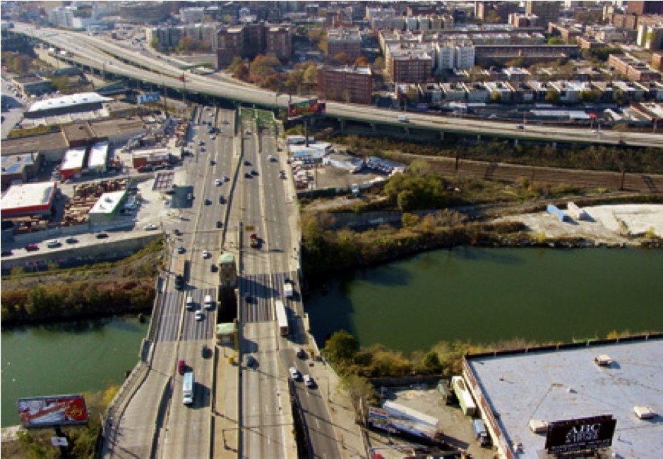
I-70, St. Louis
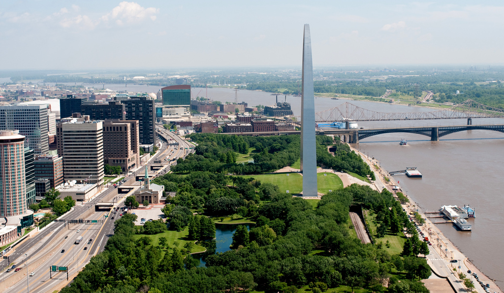
When I-70 divided the city of St. Louis from the Mississippi riverfront in 1964, its downtown suffered. In the process, one of the most iconic architectural treasures in the United States, the Gateway Arch, became isolated from the city it was intended to honor.
Demands to remove 1-70 and reconnect the city with its waterfront and arch grounds have been voiced for years. A General Management Plan became available in 2009 to work in conjunction with a design competition offered by the National Park Service calling for the "framing" of St. Louis, the Mississippi River, and Illinois, which would reinvigorate and reintroduce the Arch and Jefferson National Expansion Memorial to the community of St. Louis. The NPS "prefers and strongly supports the removal" of a 1.4 miles section that slices by the Arch grounds.
In 2012, recently elected Alderman Scott Ogilvie raised the profile of the removal efforts by introducing a resolution in City Hall to take down the elevated portion of I-70 in downtown. Additionally, a group of volunteers formed the City to River movement to improve the overall connectivity and beautification of the riverfront with downtown St. Louis by promoting the removal of I-70.
In 2013, officials fast-tracked a $380 million renovation of the Arch grounds which includes a renovated "Park Over the Highway" with enhanced pedestrian access and landscaping overtop of a depressed portion of I-70. Many advocating for the replacement of I-70 with an urban boulevard see this park, to be completed in 2015, as a half-measure, not completely reconnecting downtown Saint Louis with its waterfront or Arch grounds and a missed opportunity for the city.
It appears the City and state DOT are no longer considering the boulevard option for I-70 through downtown in the short-term, suggesting it would not improve pedestrian or bike access as well as the "Park Over the Highway" purports to do. Additionally, the new park plan is already under construction and fully funded. Luckily, the boulevard option has not been taken off the table. "If, at a future time, regional leaders determine that removing the elevated lanes of I-70 is a regional priority and would be beneficial to the region, the preferred alternative design for the Park Over the Highway would not preclude that work from happening," states MDOT. Full removal of I-70 is still the better alternative for Saint Louis, but a park over the highway may just give enough people the right angle to see this. [Image: I-70 separating downtown St. Louis from the Arch Grounds, MoDOT]
I-280, San Francisco
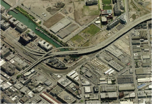
At the end of World War II, the California Highway Department had big plans for San Francisco. A lattice of freeways would have penetrated most neighborhoods in the city. But, San Franciscans resisted by stagingAmerica's first Freeway Revolt. The Embarcadero Expressway, which cut off the NE corner of San Francisco from the Bay, was stopped at Fisherman's Wharf. The Central Freeway was also halted. After the 1989 Earthquake, the Embarcadero and a portion of the Central Freeway were removed and replaced with boulevards. Both freeways were stub ends with relatively low traffic counts and thus easier to remove from both a political and technical standpoint. The Central Freeway, though shorter, is still a stub end that could be amputated from the system.
Today, another stub end, the I-280 spur north of 16th Street, is being considered for removal. In December 2012, the City of San Francisco Planning Department released the Fourth and King Street Railyards: Opportunities and Constraints Report,, completed with funding from the San Francisco County Transportation Authority. The report compared the direct costs and benefits of highway vs. boulevard conversion of the 280 “spur” alongside a 4th/King Railyards redevelopment. The study notes: “the estimated land value is significantly higher for the boulevard scenario ($228 million) than for the highway scenario ($148 million)” and suggests removing the 280 spur while make the project more “accessible” and “cohesive.”
San Francisco Mayor Ed Lee and his administration have opened discussions with the California Transportation Department and regional Metropolitan Transportation Commission about rolling back the spur, opening up land for a new passenger train station just south of the center of Downtown. Not only does removing I-280 open up more land for redevelopment, increase connectivity between neighborhoods, and expand housing options (as was done in the Embarcadero and Central Freeway removal corridors), it also puts the city on a path to be freeway-free.
With SPUR’s Taking Down a Freeway to Reconnect a Neighborhood and the Center for Architecture + Design’s design competition, as well as a feasibility study for highway removal and track relocation underway, there is clearly the collective vision and political will to remove the I-280 spur. If done correctly, San Francisco will continue to be the most cited example of successful urban freeway removals in the world. [Image: I-280 spur, SPUR]
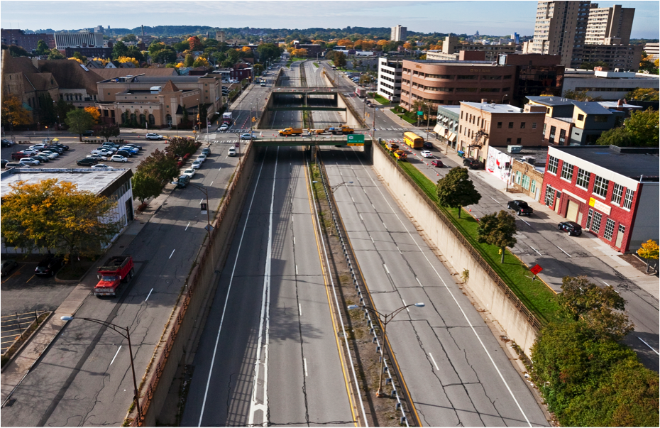
I-375, Detroit
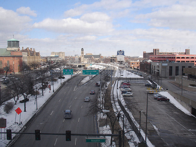
I-375 is a 1.06-mile spur that pierces Detroit's downtown. Begun in 1959, this 4-lane, below-grade freeway disconnected Detroit's Riverfront, Greektown, Eastern Market, and Stadium districts. Its legacy is tied to failed urban renewal efforts that destroyed thriving black neighborhoods. According to the U.S. Census, Detroit's population shrunk from a high of around 2 million people in 1959 to a population of about 700,000 today. Additionally, according to Michigan Department of Transportation (MDOT), the vehicle usage of I-375 has shifted markedly. Since 2009, annual daily travel averages have decreased more than 13% from 14,112 and 53,900 vehicles at the Jefferson and I-75 segments to 17,101 and 41,512 today.
Detroit is facing a number of growing problems, including the dramatic loss of its tax base over the past four decades. With the public unraveling of the City's financial woes, namely its $18.5 billion bankruptcy, the City is in the midst of a critical overhaul effort. This effort is guided by a comprehensive economic development plan called Detroit Future City, which calls for smarter land use planning and economic incentives. Many advocates and policy official agree that the removal of I-375 would fit into this plan if turned into a boulevard. MDOT Director Kirk Steudle is open to study this alternative and has stated that such a project could open up about 12 acres for development.
In December 2013, Detroit's Downtown Development Authority moved forward with a planning contract to study alternatives for I-375 from Gratiot Avenue to Atwater Street, precipitated by local organizations like the Detroit RiverFront Conservancy suggesting Detroit follow the national trend in urban freeway removal and convert I-375 into an at-grade, pedestrian friendly thoroughfare.
CNU supports the growing community of voices around removing the I-375. The business community would stand to gain from the increase in foot traffic, and a boulevard would connect Detroit's fastest growing neighborhoods and allow citizens to engage with the Riverfront more easily. Lastly, the city would be removing an eyesore from its downtown landscape and an opportunity to turn a page into a new era of transportation planning that fits in with its bicycle, rapid transit, and new light rail infrastructure. [Image: I-375 at Jefferson Ave., gab482 via flickr]
Terminal Island Freeway, Long Beach
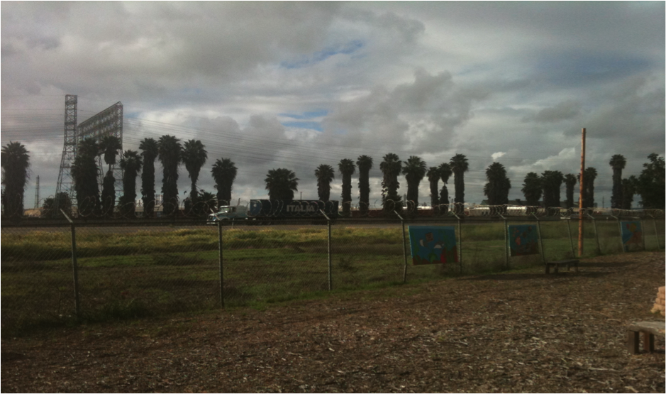
The Terminal Island Freeway in Long Beach, CA is a perfect example of obsolete infrastructure. The freeway carries a paltry 14,00 vehicles per day. It serves port freight traffic with no direct connections to surrounding freeways. Traffic counts are expected to decrease significantly as well, if Union Pacific's plans to expand the Intermodal Container Transfer Facility (abutting the freeway) come to fruition and remaining freight traffic is rerouted less than a mile west to the more heavily-trafficked Alemeda Corridor.
With the tremendous amount of underutilized right-of-way available to the City of Long Beach, residents see removal of the lightly-used Terminal Island Freeway as an opportunity. Led by local nonprofit urban design studio City Fabrick, advocates have put forth a vision for the corridor: more green, open space instead of an overbuilt freeway, creating an attractive buffer between residential development and industrial port infrastructure on Long Beach's west side.
In 2013, the effort, called the Terminal Island Transition Plan, was awarded a Caltrans grant to "provide planning and conceptual design services to develop a vision for transforming the TI Freeway into an 88-acre greenbelt and local roads that will directly benefit a disproportionately impacted environmental justice community in West Long Beach." The grant suggests the plan "presents a rare opportunity to coordinate replacing an underutilized freeway while mitigating pollution impacts to address long-standing community health concerns." The strategy is to convert the northern section of Terminal Island into a local street that connects to the city grid. This plan would open up 20 to 30 acres of land, which, if converted to a mile-long public park, would be a 50% increase in park space and also improve public health outcomes in West Long Beach. [Image: Underutilized land surrounding the Terminal Island Freeway, City Fabrick]
Aetna Viaduct, Hartford
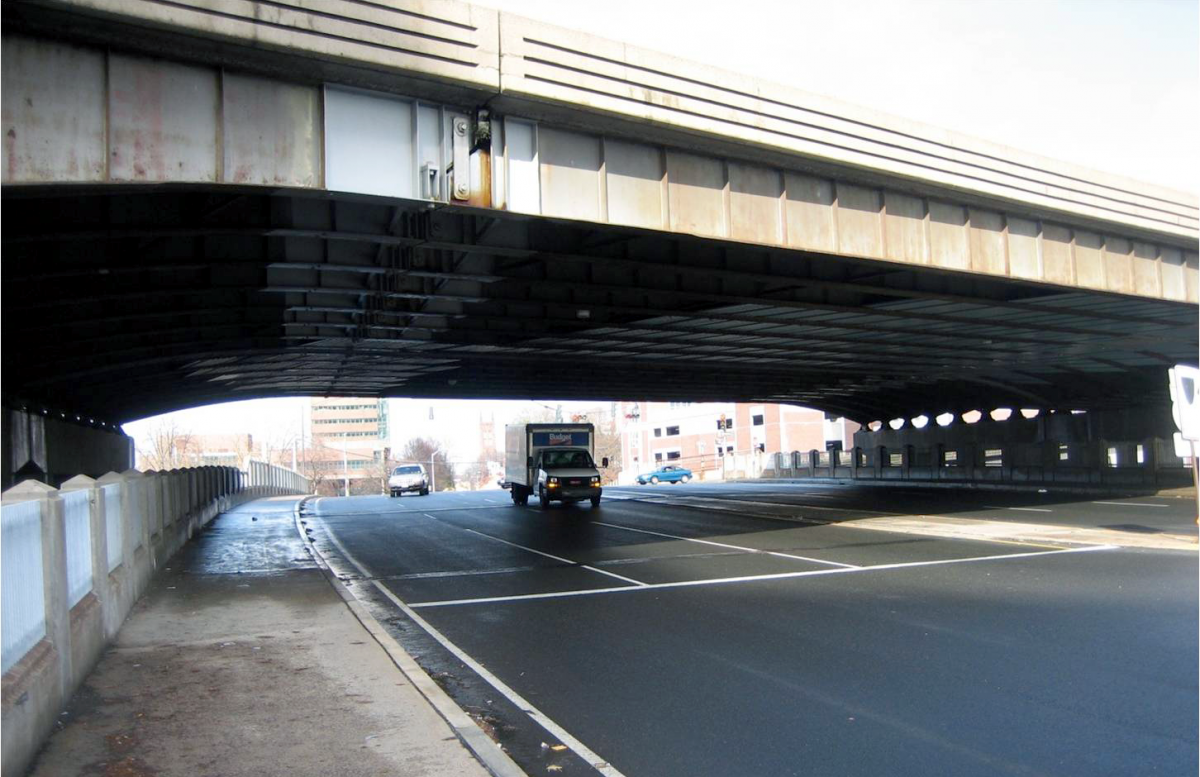
The ¾ mile elevated portion of Interstate 84 begins at Sisson Avenue and runs through the heart of downtown Hartford, Connecticut. Completed in 1965, caused significant damage to the historic neighborhoods of Hartford, destroying historic architecture and breaking the walkable connections between adjacent communities and public spaces such as Asylum Hill and Frog Hill. It also destroyed the economic vitality of the community. Downtown growth was inhibited for decades. To this day, the imposing viaduct prevents pedestrians from utilizing the space underneath, as most of the area is dedicated to surface parking.
In 2005, the viaduct reached the endpoint of its 40-year lifespan and the City of Hartford was faced with the question: How do we address this piece of infrastructure which sustains roughly 175,000 vehicles per day, the state's most heavily trafficked? The Connecticut Department of Transportation (ConnDOT) originally proposed to invest $100 million into resurfacing, effectively increasing the viaduct's lifespan another 20 years. But stakeholders voiced their opposition, loudly, urging ConnDOT to change course.
After securing federal funding, the City of Hartford hired Goody-Clancy to perform an alternatives study of the viaduct. The I-84 Viaduct Study, published in 2010, noted that while the viaduct is in need of immediate repairs, the roadway would need to be fully reconstructed or replaced within 10-15 years. Active citizens from Asylum Hill and other affected neighborhoods, with the support from then-Mayor Eddie Perez and the Connecticut Department of Transportation, joined together to form the Hub of Hartford Committee to represent and reinforce the removal of the Aetna Viaduct.
The real turning point in the campaign came from the study itself. In it, the Capitol Region of Council Governments (CRCOG) and city officials saw new opportunity in re-aligning existing train tracks north of the highway's path. Maintaining the current path of the tracks in the footprint of the highway would require an overpass, which are expansive to build and maintain. Re-aligning the tracks would take more coordination, but would not require the physically separating viaduct and be a more cost-effective alternative in the long term. Additionally, 15-20 acres of land would be made available for development and new, meaningful connections to downtown could be made.
Coordination remains crucial. Today, CRCOG is working closely with the Hub of Hartford and the City of Hartford to advocate for smart alternatives. ConnDOT is preparing engineering and environmental work for a comprehensive study to look closely at the options. The boulevard alternative was eliminated from the study early on, as the massive daily traffic volumes were thought to require an inadequate and largely unattractive urban boulevard design. [Image: I-84 through downtown Hartford, I-84 Hartford Project]
Campaigns to Watch
The following highways and their accompanying campaigns widen the original intent of the Freeways Without Futures list. CNU chose the following campaigns, several which have made the Freeways Without Futures list in the past, because they represent a kaleidoscope of possibility. However,We hold some concerns such as: the design standards chosen for some projects do not go far enough in addressing the urban context in which the freeway corridors exist, or that opponents of removal efforts are not fairly calculating the total cost of maintaining (or constructing) these roadways. Nonetheless, These campaigns exemplify the positive political and institutional shift in thinking about urban infrastructure, especially our streets.
The numerous campaigns that were left off this list are not without merit. In fact, former Freeways Without Futures campaigns like Seattle, New Haven, Miami, Cleveland, Louisville, and Somerville still need our support and attention. Likewise, campaigns with less national attention deserve to be elevated and lauded —Akron, Chicago, Denver, Ottawa, and more.
CNU has settled on the following five campaigns showing the most movement and opportunity for setting new precedents in urban freeway removal.
I-345, Dallas
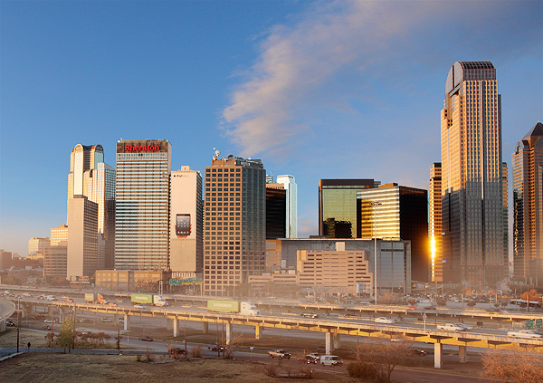
I-345 is a 1.4 mile elevated freeway between downtown Dallas and the adjacent neighborhood of Deep Ellum. It connects two freeways together: the Woodall Rogers Freeway to I-30. It is heavily trafficked, with 170,000 cars trips per day (in 2010). Constructed in 1974, it is at the end of its 40-year design lifespan and is in need of considerable maintenance. TxDOT remains committed to replacing the freeway, not removing it. Unsurprisingly, their 2012 Feasibility Study did not include a removal option.
This omission catalyzed the opposition. A New Dallas, started by locals Patrick Kennedy and Brandon Hancock, has put together a compelling case for I-345’s removal, restitching the city grid between downtown Dallas and East Dallas and opening up 245 acres of underutilized land adjacent the freeway for more walkable, transit-focused development. A New Dallas sees enormous economic benefits to this approach. Hopefully they will continue to convince other of the same. The campaign is still nascent, but the number of stakeholders on the side of removal and national attention of their work is steadily growing. [Image: D Magazine]
I-895/Sheridan Expressway, New York City (Bronx)
The Sheridan Expressway was featured on CNUs 2012, 2010, and 2008 lists. NYSDOT presented its final recommendation for the Sheridan Expressway in the Summer 2013. The City has not fully embraced the vision of the Southern Bronx River Watershed Alliance (SBRWA] to completely remove the stubby roadway. However, several of the groups recommendations made it into the final proposal including: creating more developable land in the Sheridan’s reduced footprint, taking trucks off of local streets, pedestrian improvements, closing Expressway ramps, and a more neighborhood-friendly design.
According to SBRWA, “If implemented these actions will take thousands of trucks off of local streets, increase pedestrian safety, create better access to our parks and the Bronx River and create the potential for affordable housing and local economic development.” Local advocates have taken up the cause of securing funding to complete the environmental study. They remain committed to ensuring these necessary provisions make it into the project, creating a healthier, safer, and more livable Southern Bronx. [Image: CNU]
SR-710 Extension, Alhambra & Pasadena
Over more than five decades, Southern California built out a vast freeway system that has dispersed people and the built environment across the region. Even so, some pieces of the freeway plan remain unbuilt and unresolved. SR-710, for example, was intended to connect the lower I-710 Freeway with the already heavily congested I-210 Freeway. Currently, the Los Angeles County Metropolitan Transportation Authority (LACMTA) supports an extension via a vast 4.5-mile tunnel, at an estimated cost of $5.4 billion. Some estimates go as high as $24 billion.
The fight over whether or not to extend the 710 is far reaching. Citizens in nearby El Sereno, Highland Park, La Cañada, and San Marin, in addition to the Alhambra and Pasadena communities, will be affected. Ultimately, opponents of this proposal argue that the main purpose of the tunnel will be to pass traffic through from the port. It will not reduce congestion, but increase it. The tunnel would also make air quality worse. Opponents continue to push for increased emphasis on public transit, including Bus Rapid Transit and other non-motorized transportation options as a way to address current and future traffic congestion along the corridor.
The issue has deeply divided local communities. Fortuitously, those opposing the extension are on the right side of national and regional trends. Two studies published last year affirm that Southern California residents are driving less and taking more public transportation. [Image: North end of the 710 Freeway 710studysanrafaelneighborhoodposts.com, Sarah Reingewirtz]
NYS Route 198/Scajaquada Expressway, Buffalo
Spearheaded by infamous freeway builder Robert Moses in the 1960s, the Scajaquada Expressway split an Olmsted masterpiece of Delaware Park into two halves, injecting noise, pollution, high-speed traffic through the park while visually detracting from its beauty. For more than two decades, advocates have been demanding the expressway be downgraded to a multi-modal parkway.
While still in development, the current project language from NYSDOT states the goals as “employing ‘context sensitive’ and ‘flexibility in highway design’ principles, our team will evaluate the feasibility of transforming over three miles of the Scajaquada Expressway into a landscaped boulevard featuring new at-grade intersections, enhanced pedestrian and bicyclist accommodation, improved aesthetics, and decorative lighting in an effort to reduce operating speeds, improve overall safety, and develop a community gateway.” Advocates fear the most recent recommendations from the NYSDOT Western Region are simply disguising a highway by including a few attractive design elements, falling far short of community’s expectations of a return to a more Olmsted-like past.
CNU supports local efforts to restore Olmsted’s Delaware Park and turn the Scajaquada Expressway into a parkway, equal in beauty to the Olmstedian Parkways that made Buffalo the world’s “best designed city.” [Image: Buffalo Rising]
Robert Moses Parkway, Niagara Falls
Stretching approximately 18 miles, the Robert Moses Parkway stands as a barrier between the City of Niagara Falls and one of the world’s most tremendous natural assets. This barrier also inhibits ecotourism and the restoration of natural landscapes. Initially conceived to serve industries along the waterfront —industries that have since vanished — the parkway is now underutilized highway showing its age. The parkway’s declining traffic counts prompted the closure of two of the four lanes. The non-profit organization Wild Ones, the Niagara River Greenway Commission, and the City of Niagara Falls have studied the northern section for full removal and ecological restoration.
In February 2013, the State of New York agreed to remove at least a 2-mile portion of the freeway from Main Street to Findlay Drive. The reclaimed land will be restored to parkland. The rest of the parkway is still part of considerable discussion, as only one alternative calls for removal of the full length of the parkway. The final report outlines three alternatives that are open for possible amendments in the future and subject to futher environmental study. The project will likely occur in at least two phases, with the first possibly breaking ground in 2014. Advocates wanting full removal are cautiously optimistic that more of the parkway will be removed. [Image: Dougtone via flickr]
Thanks to....
The Congress for the New Urbanism would like to acknowledge and thank the following for their support and expertise in the development of the 2014 Freeways Without Future report:
National Advisory Board Members: Jack Davis, Bonnie Fisher, Norman Garrick, Lucy Gibson, Jacky Grimshaw, Elizabeth Macdonald, John Norquist, Cary Moon, Sam Schwartz, Brent Toderian, John LaPlante and Peter Park.
![]()
Header photo credit: Dan Backman, flickr