- Who We Are
- What We Do
- Our Issues
- Our Projects
- Sprawl Retrofit
- Highways to Boulevards
- CNU/ITE Manual
- Health Districts
- The Project for Code Reform
- Lean Urbanism
- LEED for Neighborhood Development
- Missing Middle Housing
- Small-Scale Developers & Builders
- Emergency Response
- HUD HOPE VI
- Rainwater in Context
- Street Networks
- HUD Finance Reform
- Affordable Neighborhoods
- Autonomous Vehicles
- Legacy Projects
- Build Great Places
- Education & Trainings
- Charter Awards
- Annual Congress
- Athena Medals
- Resources
- Get Involved
- Donate
- Membership
- Public Square


2012 Freeways Without Futures lists the top opportunities in North America for replace aging urban highways with boulevards. With assistance from the Ford Foundation, CNU convened a national advisory board of experts and activists to discuss urban freeway removal in 2011. CNU also distributed a survey to assess public support for urban freeway teardown projects. After considerable deliberation, CNU prepared the 2012 Freeways Without Futures report and built a North American urban freeways database.
The 2012 list is based on a number of factors: the age and design of structures, redevelopment potential, potential cost savings, ability to improve both overall mobility and local access, existence of pending infrastructure decisions, and community support.
Top Teardown Projects
1. I-10/Claiborne Overpass, New Orleans
 In the 1960s, Interstate 10 (I-10) replaced North Claiborne Avenue, a thriving commercial strip in the neighborhoods of Tulane/Gravier, Tremé/Lafitte and the 7th Ward. In 1966, the oak trees that lined the avenue were destroyed or in some cases transplanted to other parts of the city and were replaced by concrete columns to support the elevated highway. As a result of the highway construction, Tremé - one of the first free African-American communities, and once one of the wealthiest – was divided by the expressway which was built directly over Claiborne Avenue, its main street and commercial and cultural heart.
Following Hurricane Katrina and the subsequent rebuilding efforts, there was an increasing call to rethink I-10’s role for the North Claiborne Corridor, especially due to the age of the structure and the damaged sustained by the storm. The Unified New Orleans Plan (UNOP), a comprehensive planning process to coordinate recovery and rebuilding after Hurricane Katrina, identified that the removal of I-10 "would have considerable positive impacts by re-connecting neighborhoods and restoring what was once a beautiful tree-lined avenue. Traffic redistribution provides economic development benefits to a corridor ripe for more volume." The UNOP predicts that with the full removal of two miles of the elevated I-10, the city will gain 35 to 40 city blocks that will no longer be blighted by the freeway and 20 to 25 blocks of open space along Claiborne Avenue.
The community-led design charrettes held by the UNOP and NOLA Master Plan groups in recent years have encouraged residents to voice their hopes for their community. Both plans called for traffic and environmental impact studies and feasibility reports of removing the inner-city portion of the Interstate 10 elevated expressway. The Master Plan is expected to be adopted by City Council and become the official plan, giving the City force of law that will invigorate new life into the 7th Ward. The City of New Orleans received TIGER II funds in July 2010 to finance a transportation study of the corridor. The City released the request for services necessary to execute the federal transportation study grant in January 2012.
[Image: The I-10 Expressway towering over Claiborne Avenue. Bill Borah]
2. I-895/Sheridan Expressway, New York City (Bronx)
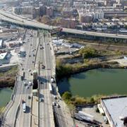 Built in 1963, the Arthur V. Sheridan Expressway, also known as I-895, was designed by Robert Moses to connect the Bruckner Expressway (I-278) with the New England Thruway (I-95) in the Bronx. Influential stakeholders were able to curb the second phase of the expressway, a four-mile expansion slated to pass through the Bronx Zoo and New York Botanical Gardens. However the beginning phases of the project were already complete and left the Sheridan as an awkward, poorly-connected 1.25-mile spur that mars the waterfront along the Bronx River. The Sheridan currently carries 35,000 vehicles per day between Bruckner Expressway and Westchester Avenue. Less traffic travels on the Sheridan than many of the nearby major thoroughfares such as the Bruckner Expressway (117,000 vehicles per day).
In 1997, The New York State Department of Transportation (NYSDOT) proposed a $245 million project to reconstruct and extend the expressway. Residents of the area voiced their opposition to this project and a handful of community groups formed the Southern Bronx River Watershed Alliance (SBRWA) and created a Community Plan that NYSDOT agreed to study. Their vision replaces the freeway with a surface street, improves street grid connectivity, and reclaims 28 acres of land for commercial development, housing and open space along the waterfront. In addition, the SBRWA is calling to build ramps off the Bruckner Expressway so that trucks may access the Hunts Pointer Terminal Markets without driving through the community.
NYSDOT is now analyzing two final scenarios for the future of Sheridan Expressway: one, retaining the Expressway and two, removing the Expressway entirely. The SBRWA revealed that NYSDOT's traffic analysis had many flaws in its methodology and responded by calling in the transportation engineering and planning firm Smart Mobility, Inc. to provide an independent engineering review of the initial DOT findings. The firm's findings showed that the NYSDOT study did not consider the benefits of redeveloping 28 acres of land currently occupied by the Sheridan. To ensure that the land use and transportation benefits of freeway removal were fully explored, the Alliance was closely involved with New York City's study of the Sheridan corridor, which is funded by a federal TIGER II planning grant. The SBRWA is currently working to ensure that local stakeholders and community residents are involved with the process, and that the Community Plan becomes a reality.
[Image: The Sheridan Expressway meeting Bruckner Expressway. URS Corporation]
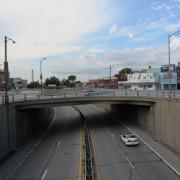
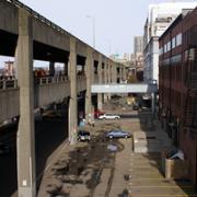
3. Route 34/Oak Street Connector, New Haven
 Perhaps ironically nicknamed, the Oak Street Connector, Route 34 begins at the junction of Interstates 95 and 91 and extends into downtown New Haven for 1.1 miles before dropping below grade at College Street and continuing as a pair of one-way streets. Route 34 carries 73,900 vehicles on the route per day. The Connector, built in 1959, occupies 26 acres of land between downtown and the adjacent neighborhood. The original plan was to extend the road an additional 10 miles, but that long section faced neighborhood opposition and was never constructed. Ultimately, 600 families and 65 businesses were displaced for a highway that functions as an elongated ramp from the Interstate. The Connector reduced the connectivity of the neighborhood street network and damaged the economic vitality of nearby businesses.
In 2002, the State of Connecticut sold the land that had been set aside for the extension of the Oak Street Connector. In 2005, with the completion of Pfizer Pharmaceutical's research facility in the former planned right-of-way, the City of New Haven and local civic groups began calling for the replacement of the Oak Street Connector with a four-lane boulevard. A concept plan identified ten acres of vacant land to redevelop and two street connections to restore, along with a larger surrounding area to be revitalized. New Haven's Mayor, John DeStefano, Jr. included the removal of the Connector in Future Framework 2008 as an urban infill strategy. The Tri-State Transportation Campaign and the Urban Design League of New Haven are actively campaigning for the replacement of the depressed and paired one-way sections of Route 34 with walkable, pedestrian-friendly streets and blocks.
In early 2010, Mayor DeStefano announced the initial phases of the removal of Route 34 starting with 100 College Street, in his address to the City. New Haven was awarded a TIGER II grant with the Connecticut Department of Transportation (CONNDOT) to prepare an Environmental Impact Statement (EIS). Controversy continues over the scale of the new surface street. Residents and activists have pushed for greater pedestrian safeguards and to reduce the number of lanes in the current Downtown Crossing plan. There are plans to remove the freeway in 2016.
[Image: Route 34 as it ends underneath a parking garage (lower left). GATM.com]
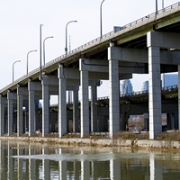
4. Route 5/Skyway, Buffalo
 Buffalonians have long recognized the towering Skyway Bridge as a barrier to waterfront redevelopment. Completed in 1956, this 1.4-mile long, 110-foot tall limited-access bridge begins at the Inner Harbor downtown, crosses the Buffalo River and touches down as Route 5 in the Outer Harbor. Route 5 continues for another 2.6 miles as a limited-access expressway built on an embankment of slag. The highway's oddly configured exit ramps lead to a confusing series of one-way streets that further hinder access to the waterfront. A total of 41,500 vehicles per day travel along this blighted corridor. There is no pedestrian access between downtown and the Outer Harbor.
Despite calls for redevelopment and the fact that a boulevard-only option was deemed viable in the project's environmental impact statement, the NYSDOT selected to retain the embanked Route 5 and reinforce it with new ramps, instead of replacing it with a surface boulevard supporting an urban street-and-block network. NYSDOT's current plan leaves aside the fate of the Skyway Bridge, but its decision to retain the embanked Route 5 will necessitate that the Skyway Bridge be replaced by a similar, high-speed expressway facility. It also rebuilds and reconfigures an access road adjacent to the embanked freeway, resulting in a total of eight lanes of roadway with a right-of-way width of 214 feet. The agency's designs, which leave waterfront access highly restricted and promote auto-dependent land uses, set the stage for limited reinvestment on the waterfront.
A coalition of citizens and civic organizations, including members of the Buffalo Common Council, David Franczyk and Michael Kearns, Partners for a Livable Western New York, Buffalo Niagara Riverkeeper, and CNU continue to call for a surface boulevard option noting its environmental and economic development benefits. Their plan would utilize an additional 16 acres of waterfront land which would otherwise be paved or inaccessible in the NYSDOT plan. The Buffalo Niagara Riverkeeper, Buffalo Waterfront Coalition, and Partnership for Public Good have either publically or legally challenged NYSDOT’s rejection of a boulevard alternative. Since 2008, NYSDOT and Federal Highway Administration have implemented the “preferred alternative” that includes a set of arterials and lets the Skyway remain standing.
[Image: CNU]
5. I-395/Overtown Expressway, Miami
 Settled in the 1890’s—before Miami was even incorporated—Overtown is the historic heart of the city’s black community. In the first half of the twentieth century, Overtown was a port of entry for black immigrants from Cuba, Barbados, Haiti, Trinidad & Tobago, and Jamaica. By 1965, half of Overtown’s population had been displaced to make way for the construction of a major interchange between I-95, I-395, and State Highway 836.
For years, planners have suggested initiatives to mitigate the impact of the 1.3-mile I-395 spur, which connects I-95 to Miami Beach. In 2002 there was a proposal to replace the highway with an open-cut, below grade freeway, reintroduce smaller blocks and mixed uses into the area, and possibly re-create a jazz and entertainment district. In February of 2010, the Federal Highway Administration (FHWA) conducted a Final Environmental Impact Statement, which evaluated five different alternatives for I-395—a no-build option, two elevated alternatives, one tunnel alternative, and one open-cut, below-grade alternative.
The Florida DOT (FDOT) argued that a super-elevated highway would offer a more affordable method of restoring property values to the area while serving transportation needs. As of October 2010, FDOT were still advocating reconstruction as a super-elevated highway, at a cost of about $580 million. This option would increase the highway from four to six lanes and create emergency lanes. This option was included in Miami-Dade County's 2035 Long Range Plan.
The final environmental impact statement, completed by FDOT and FHWA, in February of 2010, postulated that any rebuild must achieve increased capacity; it identified an elevated freeway as the only viable construction option. There is some degree of organized neighborhood opposition to this initiative, but FDOT has moved forward with lane expansion and repairs totaling $7.5 million already. In July of 2010, FHWA issued a record of decision that selected one of the elevated freeway alternatives presented in the Final EIS.
[Image: Collins Center for Public Policy]
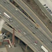
6. I-70, St. Louis
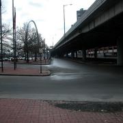 When I-70 divided the city of St. Louis from the Mississippi riverfront in 1964, it devastated the vitality of the downtown area and isolated one of the most iconic architectural treasures in the United States, the Gateway Arch, from the city.
Calls to remove the highway had been voiced in years past and many now find it imperative to enhance the connection between city and riverfront. According to theMissouri Department of Transportation (MODOT) “the downtown lanes [of I-70] are one of the least traveled sections of interstate in the Saint Louis area. Currently the majority of approximately 70,000 vehicles per day in this section are traveling through Saint Louis to points west. With the rerouting of I-70 it is probable that that amount of traffic could be reduced by greater than 50%.”
A General Management Plan became available in 2009 to work in conjunction with adesign competition offered by the National Park Service calling for the “framing” of St. Louis, the Mississippi River, and Illinois, which will reinvigorate and reintroduce the Arch and Jefferson National Expansion Memorial back to the community of St. Louis. The NPS “prefers and strongly supports the removal of the Interstate highway." Acting as a city-wide voice, a group of volunteers formed the City to River movement to improve the overall connectivity and beautification of the riverfront with downtown St. Louis by promoting the removal of I-70. With their guidance, efforts are underway to coordinate the removal with the remodeling of the Jefferson National Expansion Memorial to make way for a surface boulevard and other walkable alternatives.
[Image: I-70 separating downtown St. Louis from the Arch. Ecology of Absence]
7. West Shoreway, Cleveland
 The Cleveland Memorial Shoreway, the first east-west freeway in Greater Cleveland, was opened to traffic in 1938. The road was built using work relief funds and labor from the Depression-Era Works Progress Administration (WPA). It was the largest WPA project in the country at the time. In 1944, city, county, and state agencies released a master plan for limited-access highways. An addition to the highway in 1953 turned the Shoreway into an eight-lane, nonstop expressway. This grade-separated highway had the unintended consequence of severing neighborhoods such as Ohio City and Detroit-Shoreway from the Lakefront.
The current highway is underutilized (with about 32,000 cars per day), and ripe for transformation into a more urban-appropriate thoroughfare type. The City of Cleveland has been planning a 2.5-mile conversion since 2003. After extensive negotiations with state officials, they settled on a six-lane boulevard, with possible dedicated bus lanes during peak hours. Work started in 2010 and should be completed by 2014. The speed limit will be reduced from 50 MPH to 30 MPH; this will add about 75 seconds to total trip times.
In August of 2011, the Ohio Department of Transportation (ODOT) dramatically increased the project’s price projections, from $70 million to $103 million due to eight years of inflation and unanticipated sewer and railroad costs. The State currently has only $50 million in federal funds on hand; the City has proposed various cost-cutting measures to address the shortfall. In December 2011, activists and supporters includingMayor Frank Jackson and Councilman Matt Zone petitioned ODOT for the $28.2 million needed to complete the second phase of the project. ODOT will complete their project prioritization, including funds affecting the West Shoreway, in March 2012.
[Image: Infrastructurist]
8. I-490/Inner Loop, Rochester
 In the early 1950’s, when construction began on Rochester’s Inner Loop Highway, the city’s population was about 330,000. In 1965, the two-mile Inner Loop was initially opened to traffic. Today, Rochester is a shrunken city of about 210,000, with 50,000 jobs in its downtown core (in a metropolitan area of over 1,000,000).
The highway, built for a more populous city during an era of planning dedicated almost exclusively for automobility, completely encircles its downtown. It is widely perceived to be a major barrier between the downtown district and its neighboring, densely-populated neighborhoods. While central Rochester is experiencing somewhat of a rebirth, much of the urban fabric near the Inner Loop is harmed by vacant land and underutilization.
While the much larger I-490 is as a small part of the Inner Loop, most of the route—a 2.68-mile stretch—exists only to surround the downtown. Part of the highway serves large traffic volumes (up to 46,500 a day). Other segments are extremely underutilized. In particular, a section to the east carries only 10,500 cars/day, low enough to be handled by a modest urban avenue. This part of the Inner Loop, bordering the popular East End, has been strongly targeted for replacement with an at-grade boulevard.
Boulevard conversion of this section was a major component of Rochester 2010: The Renaissance Plan, in 1999. This was followed by the 2001 Inner Loop Improvement Study. In 2009, the City made a $22 million TIGER funding request for the Inner Loop East Reconstruction & Realignment Project. In September 2009, Rochester City Council (with the support of Mayor Tom Richards) agreed to fill the Inner Loop between Monroe Avenue and Charlotte Street (.6 miles). They are requesting a $15 million federal grant, and will need to raise about $5 million in local funds.
According to the previous TIGER application, the proposal will add only 2.2 seconds of evening peak delay, while creating 9.4 acres of developable land. It will greatly reduce a highway facility that is 160-225 feet wide including frontage roads with as many as twelve lanes. And, of course, it will increase the desirability of land on the current highway periphery.
[Image: Joseph Avenue, looking east; Tim Raymond and Linda Magi]
9. I-81, Syracuse
 The construction of Interstate 81 (I-81) in Syracuse in 1957 destroyed a historic black community, ruined the economic activity within the area, and caused major barriers to development since its construction. Average annual daily traffic on I-81 ranges from about 43,000 to 99,000 vehicle per day as it runs just east of downtown and connects with I-690. As with many structures from this era, this six-lane structure is near the end of its design life and more attention is being paid to the negative effects that I-81 brings to downtown Syracuse.
In 2001, Syracuse Common Councilor Van Robinson called for the removal of elevated portions of the interstate. Leading figures from Syracuse University and Upstate Medical University, who see I-81 as an eyesore and impediment to the growth of their respective institutions, have also joined the discussion with support for removal. Robinson envisions nearby I-481 as the main carrier for through-traffic, while elevated I-81 would become an urban boulevard.
The Syracuse Metropolitan Transportation Council and the New York State Department of Transportation (NYSDOT) are co-leading a multi-year study to review potential alternatives and analyze traffic with input from the public. Additionally, the Onondaga Citizens Leagueconducted a study entitled "Rethinking I-81," which will focus on the social, economic, and cultural effects of possible alternatives. In early 2010, the decision over what to do with the structure remains an issue of major debate, especially among commuters, in Syracuse. The SMTC is offering reassurance that no matter which option they choose for I-81's fate, the plans will be carefully studied and crafted to suit the citizens of Syracuse.
[Image: I-81 bisecting Syracuse neighborhoods. Syracuse.com]
10. Gardiner Expressway, Toronto
 Built between 1955 and 1966 by the Ministry of Transportation of Toronto (MTO), Toronto's Frederick G. Gardiner Expressway is a major east-west thoroughfare that connects downtown Toronto to its western suburbs. The Gardiner's elevated eight lanes separate the city's bustling core from its Lake Ontario waterfront. What was originally built to accommodate 70,000 cars daily now carries around 200,000 and costs $6 to 10 million annually in repairs.
For years, citizens of Toronto have called for the removal of the elevated expressway as it runs from downtown eastward. And they've had some success. A far eastern portion of the elevated freeway, which had been intended as a connection to the suburb of Scarborough, but left as a 1.3 km stub following a citizens' revolt, was successfully removed in 1999. The result was a beautiful linear park that includes bikeways and public art installations.
WATERFRONToronto, an economic development corporation, has called for a partial teardown of the expressway and the building of an eight-lane urban boulevard in its place. On July 15, 2008, the City's Executive Committeeapproved an $11 million environmental assessment project that is a major first step in removing this one-mile portion of the freeway between the Don Valley Expressway and Jarvis street. Depending on how the eight lanes are designed, this project has the potential to create a more walkable environment. Former Toronto Mayor David Miller believes that freeway teardown to be "the most practical approach and offers the greatest public benefits."
[Image: Nelson Cruz]
11. Aetna Viaduct, Hartford
 The elevated portion of Interstate 84 begins at Sisson Avenue and runs through the heart of downtown Hartford, Connecticut. The Aetna Viaduct segment of the Interstate is a three-quarters of a mile concrete separation that prevents Hartford pedestrians from utilizing the space underneath the highway, as most of the area is dedicated to surface parking. The construction of the Aetna Viaduct also caused the loss of historic architecture and severed connections between the neighborhood and public spaces of Asylum Hill, isolating downtown growth for years to come.
In 2005, the viaduct of I-84 reached the endpoint of its 40-year lifespan and the City of Hartford was left at a turning point on how to address the structure, which bolsters roughly 175,000 vehicles per day. The City could repair any damage to the structure to increase its lifespan another 20 years, or pursue new alternatives that would heal and reconnect downtown with the rest of Hartford. The Connecticut Department of Transportation originally proposed to invest $100 million into resurfacing the aging structure, but stakeholders voiced their opposition, urging the City and ConnDOT to change their course of action.
After securing federal funding, the City hired Goody-Clancy to perform an alternatives study of the viaduct. Goody-Clancy published results in October 2010 that noted that while the viaduct is need of immediate repairs, the roadway will also need to be fully reconstructed or replaced within 10-15 years. Active citizens from Asylum Hill and other affected neighborhoods, with the support from Mayor Eddie Perez and the Connecticut Department of Transportation, joined together to form the Hub of Hartford Committee to represent and enforce the removal of the Aetna Viaduct. The Capitol Region of Council Governments is working closely with the Hub of Hartford and is representing the initial phase of this project on behalf of the City of Hartford. As of February 2011, Connecticut Department of Transportation has scheduled immediate infrastructure repair for I-84 as a part of the phased Springfield Line Commuter Rail Service plan.
[Image: The Aetna Viaduct. TSTC]
12. Route 99/Alaskan Way Viaduct, Seattle
 In 2001, the Nisqually Earthquake shook the elevated Alaskan Way Viaduct, requiring costly emergency repairs and calling into question its long-term viability. The City of Seattle and the State of Washington have been wrestling with what to do with the aging, precarious structure ever since. Built in 1953, as State Route 99, the Alaskan Way Viaduct is a north-south route alongside Seattle's Elliot Bay, and carries approximately 123,000 vehicles per day. Proposals released by the Washington State Department of Transportation for an expanded elevated highway or a tunnel during the downtown segment, each with price tags of $4 billion or more, were met with fierce opposition. In 2007, Seattleites voted both of these options down in a local referendum welcoming in a surface and transit option.
With participation from City Council and the formation of the People's Waterfront Coalition, led by Cary Moon, citizen activists envisioned an open waterfront that would begin to restore the shoreline and support a vibrant urban place. Opening up 335 acres of public land on Seattle’s waterfront could give way to new parks, beaches, and development while saving the city years of construction delays and billions of dollars. "If you try to build your way out of congestion," said Moon, "you'll ruin your city or go broke trying."
In early 2009, the Washington State Department of Transportation in cooperation with the Seattle Department of Transportation, Governor Christine Gregoire, and ex-Mayor Greg Nickels signed a Letter of Agreement recommending a bored-tunnel option to replace the viaduct, amidst concerns from Seattle stakeholders hoping for a surface boulevard replacement. In the November 2009 Mayoral election, Mike McGinn replaced Greg Nickels in office, replacing hope in citizens that their dream waterfront may be achieved as portions of his campaign were focused on the ASV boulevard replacement. While the opportunity to replace the Viaduct remained on the table for Seattle voters, anAugust 2011 referendum determined that taxpayers favored the $2 billion dollar tunnel project. Some claim that the vote is decisive, but the combination of a shaky municipal financing, inflation, and changing attitudes toward oil dependency may make the boulevard proposal relevant and cost-effective in the long run.
[Image: reverendkomissar]
View Freeways Without Futures 2012 in a full screen map
Thanks to....
The Congress for the New Urbanism would like to acknowledge and thank the following for their support and expertise in the development of the 2012 Freeways Without Future report:
National Advisory Board Members: Jack Davis, Bonnie Fisher, Norman Garrick, Lucy Gibson, Jacky Grimshaw, Elizabeth Macdonald, John Norquist, Cary Moon, Kate Slevin, Sam Schwartz, and John LaPlante (non-voting advisor).
CNU Contributors: Rik Adamski, Nora Beck, Michael Carney, Caitlin Ghoshal, and Ben Schulman.