- Who We Are
- What We Do
- Our Issues
- Our Projects
- Sprawl Retrofit
- Highways to Boulevards
- CNU/ITE Manual
- Health Districts
- The Project for Code Reform
- Lean Urbanism
- LEED for Neighborhood Development
- Missing Middle Housing
- Small-Scale Developers & Builders
- Emergency Response
- HUD HOPE VI
- Rainwater in Context
- Street Networks
- HUD Finance Reform
- Affordable Neighborhoods
- Autonomous Vehicles
- Legacy Projects
- Build Great Places
- Education & Trainings
- Charter Awards
- Annual Congress
- Athena Medals
- Resources
- Get Involved
- Donate
- Membership
- Public Square


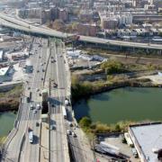
The 2010 Freeways Without Futures list recognizes the top locations in North America with a great opportunity to stimulate valuable revitalization by replacing aging urban highways with boulevards. The 2010 list builds on CNU's 2008 list and is based on a number of factors including the age of the structure, redevelopment potential, potential cost savings, ability to improve both overall mobility and local access, existence of pending infrastructure decisions, and local support.
Cities around the world are replacing urban highways with surface streets, saving millions of dollars on transportation infrastructure and revitalizing adjacent land with walkable, compact neighborhoods. Transportation investments that support connected street grids, improved transit, and revitalized urbanism will make reducing oil dependency and greenhouse gas emissions that much more convenient. It pays to consider them as cities evaluate their renewal strategies and as the U.S. evaluates its federal transportation and climate policy.
Top Teardown Prospects
1. Alaskan Way Viaduct, Seattle, WA
 Update as March 2010: "STOP THE BIG DIG WEST" has become a rallying cry for CNU and its like-minded supporters in its goal of preventing WSDOT and the Seattle City Council's push for a $3.1 billion bored-hole tunnel to replace the Alaskan Way Viaduct. Through our outreach efforts to members and media, and op-ed pieces from CNU Board member Scott Bernstein and CNU CEO & President John Norquist in Seattle weekly The Stranger, CNU is at the forefront of this issue. Read the latest update by clicking here.
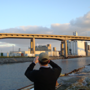
In 2001, the Nisqually Earthquake shook the elevated Alaskan Way Viaduct, requiring costly emergency repairs and calling into question its long-term viability. The City of Seattle and the State of Washington have been wrestling with what to do with the aging, precarious structure ever since. Built in 1953, as State Route 99, the Alaskan Way Viaduct is a north-south route alongside Seattle's Elliot Bay and carries approximately 105,000 vehicles per day. Proposals released by the Washington State Department of Transportation for an expanded elevated highway or a tunnel during the downtown segment, each with price tags of $4 billion or more, were met with fierce opposition. In 2007, Seattleites voted both of these options down in a local referendum welcoming in a surface and transit option.
With participation from City Council and the formation of the People's Waterfront Coalition, led by Cary Moon, they envisioned and encourage an open waterfront that would begin to restore the shoreline and support a vibrant urban place. Opening up 335 acres of public land on Seattle"s waterfront could give way to new parks, beaches, and development while saving the city years of construction delays and billions of dollars. "If you try to build your way out of congestion," said Moon, "you'll ruin your city or go broke trying."
In early 2009 , the Washington State Department of Transportation in cooperation with theSeattle Department of Transportation, Governor Christine Gregoire, and ex-Mayor Greg Nickels signed a Letter of Agreement recommending a bored-tunnel option to replace the viaduct, amidst concerns from Seattle stakeholders hoping for a surface boulevard replacement. In the November 2009 Mayoral election, Mike McGinn replaced Greg Nickels in office, replacing hope in citizens that their dream waterfront may be achieved as portions of his campaign were focused on the ASV boulevard replacement. As of 2010, a Supplemental Draft Environmental Impact Statement (SDEIS) for the bored tunnel option is underway with results availble for public review sometime this year allowing more support for the boulevard option to shine through. (Image: reverendkomissar)
2. Sheridan Expressway, Bronx, NY
 Built in 1963, the Arthur V. Sheridan Expressway, also known as I-895, was designed by Robert Moses to connect the Bruckner Expressway (I-278) with the New England Thruway (I-95) in the Bronx. Influential stakeholders were able to curb the the second phase of the expressway, a four mile expansion slated to pass through the Bronx Zoo and New York Botanical Gardens. However the beginning phases of the project were already complete and this left the Sheridan as an awkward, poorly connected 1.25-mile spur that mars the waterfront along the Bronx River. The Sheridan currently carries 39,000 vehicles per day, less than most of the nearby surface streets.
In 1997, The New York State Department of Transportation (NYSDOT) proposed a $245 million reconstruction of the expressway along with new ramps for trucks to gain easier access to Hunts Point Market to alleviate congestion and improve safety, when in reality it would have the opposite effect. Residents of the area voiced their opposition to this project and a handful of community groups formed the Southern Bronx River Watershed Alliance (SBRWA) and created a Community Plan that NYSDOT agreed to study. Their vision replaces the freeway with a surface street, improves street grid connectivity, and reclaims 28 acres of land for commercial development, housing and open space along the waterfront.
The Alliance's alternative vision was later included as one of the four options in the NYSDOT's impact study. NYSDOT is now trying to narrow its options and develop a detailed Environmental Impact Statement (EIS) before proceeding to the construction phase. SBRWA called in the transportation engineering and planning firm Smart Mobility, Inc. to provide an independent engineering review of the initial DOT findings. They reported that none of the other options offered traffic advantages over the Alliance's alternative vision. Tri-State Transportation Campaign, an organization whose efforts are focused on reducing auto-dependency, has been standing behind the removal of the expressway. As recently as November 2009, the TSTC provided testimony regarding the NYSDOT's decision to allocate only $2 million in funding, presumably to finish the studies already in progress, from the Sheridan Expressway project. TSTC criticized their "misplaced" priorities and focsed on the importance of the mixed-used development, green space, housing, and economic opportunities that would become available should the highway be removed. ( (Image: The Sheridan Expressway meeting Bruckner Expressway. URS Corporation.)
3. Claiborne Expressway, New Orleans, LA
 In the 1950s, Interstate 10 (I-10) replaced North Claiborne Avenue, a tree-lined boulevard that was home to a thriving business district in the neighborhoods of Tulane/Gravier, Tremé/Lafitte and the 7th Ward. Tremé was one of the first free African-American communities and one of the wealthiest before the freeway devastated local businesses, severed connections between residential neighborhoods, and destroyed the live oaks that once lined the broad avenue.
Following Hurricane Katrina and the subsequent rebuilding efforts, the call became prominent to rethink the I-10 elevated expressway's role for the North Claiborne Corridor, especially due to the age of the structure and the damaged sustained by the storm. The Unified New Orleans Plan (UNOP), a massive planning process to coordinate recovery and rebuilding after Hurricane Katrina, identified that the removal of I-10 "would have considerable positive impacts by re-connecting neighborhoods and restoring what was once a beautiful tree-lined avenue. Traffic redistribution provides economic development benefits to a corridor ripe for more volume." The UNOP predicts that with the full removal of two miles of the elevated I-10, the city will gain 35 to 40 city blocks that will no longer be blighted by the freeway and 20 to 25 blocks of open space along Claiborne Avenue.
The community design charrettes held by the UNOP and NOLA Master Plan groups over the last year encouraged residents to voice their hopes of what they wish to achieve within their community. Both plans called for traffic and environmental impact studies and feasibility reports of removing the inner-city portion of the Interstate 10 elevated expressway. The Master Plan is expected to be adopted by City Council and become the official plan, giving the City force of law that will invigorate new life into the 7th ward. (Image: Claiborne Expressway towering over a neighborhood street. Bill Borah)
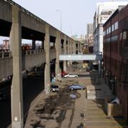
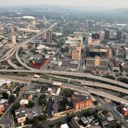
4. Interstate 70, St. Louis, MO
 The construction of the elevated and depressed lanes of I-70 that divides the city of St. Louis from the riverfront devastated the vitality of downtown area and isolates one of the most historic treasures in the United States, the Gateway Arch, cut off from the city before it even reached completion.
Calls to remove the highway had been voiced in years past and many now find it imperative to enhance the connection between city and riverfront. According to the Missouri Department of Transportation (MODOT) “the downtown lanes [of I-70] are one of the least traveled sections of interstate in the Saint Louis area. Currently the majority of the 73,000 vehicles per day in this section are traveling through Saint Louis to points west. With the rerouting of I-70 it is probable that that amount of traffic could be reduced by greater than 50%.”
A General Management Plan became available in 2009 to work in conjunction with a design competition offered by the National Park Service calling for the “framing” of St. Louis, the Mississippi River, and Illinois, which will reinvigorate and reintroduce the Arch and Jefferson National Expansion Memorial back to the community of St. Louis. The NPS “prefers and strongly supports the removal of the Interstate highway." Acting as a city-wide voice, a group of volunteers formed the City to River movement to improve the overall connectivity and beautification of the riverfront with downtown St. Louis, the removal of I-70 as their top priority. With their guidance, efforts are underway to coordinate the removal with the remodeling of the Jefferson National Expansion Memorial to make way for a surface boulevard and other walkable alternatives. (Image: I-70 separating downtown St. Louis from the Arch. Ecology of Absence.)
5. Interstate 64, Louisville, KY
 Louisville's riverfront, while lined with an award-winning park, is currently separated from downtown by an elevated, 6-lane portion of Interstate 64 (I-64), which connects with Interstate 65 and Interstate 71 just east of the downtown. In September 2003, the States of Kentucky and Indiana, working with the Federal Highway Administration, approved the Ohio River Bridges Project (ORBP), a project that adds two new bridges crossing the Ohio River and expands the junction of I-65, I-71, and I-64 in downtown Louisville. The project is estimated to cost $4.1 billion, with $1.6 billion going towards the expanded 23-lane interchange, commonly known as Spaghetti Junction.
Highly unwelcome by Louisville citizens, the organization 8664.org, has been opposing the growth of Spaghetti Junction and calling for the rerouting of I-64 to a northern bypass around Louisville. This would result in a much simpler junction downtown and conversion of 2 miles of freeway from its existing limited-access configuration to an at-grade boulevard alongside a riverfront park. A feasibility report performed by Walter Kulash, presents community and economic benefits along with impressive sustainability actions into the future, while maintaining a much more cost-efficient plan compared to the ORBP. The report predicts that with the rerouting, 20,000 vehicles per day would move to the bypass, 45,000 could be handled by the riverfront boulevard, and the rest could be easily accommodated by the existing street grid which currently has a 174,000-vehicle-per-day spare capacity on east-west streets in or near the riverfront corridor. As of August 2008, the Kentucky Transportation Cabinet temporarily suspended study of the 8664.org plan. (Image: the proposed configuration of the ORBP. 8664.org.)
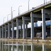
6. The Skyway and Route 5, Buffalo, NY
 Buffalonians have long recognized the towering Skyway Bridge as a barrier to waterfront redevelopment. Built in 1953, this 1.4-mile long, 110-foot tall limited-access bridge begins at the Inner Harbor downtown, crosses the Buffalo River and touches down as Route 5 in the Outer Harbor. Route 5 continues for another 2.6 miles as a limited-access expressway built on an embankment of slag. The highway's oddly configured exit ramps lead to a confusing series of one-way streets that further hinder access to the waterfront. A total of 41,500 vehicles per day travel along this blighted corridor. There is no pedestrian access between downtown and the Outer Harbor.
Despite calls for redevelopment of this area, the NYSDOT selected to retain the embanked Route 5 (and reinforce it with new ramps) instead of replacing it with a surface boulevard supporting an urban street-and-block network, even though a boulevard-only option was deemed viable in the project's environmental impact statement. NYSDOT's current plan leaves aside the fate of the Skyway Bridge, but its decision to retain the embanked Route 5 will necessitate that the Skyway Bridge be replaced by a similar, high-speed expressway facility. It also rebuilds and reconfigures an access road adjacent to the embanked freeway, resulting in a total of 8 lanes of roadway with a right-of-way width of 214 feet. The agency's designs, which leave waterfront access highly restricted and promote auto-dependent land uses, set the stage for limited reinvestment on the waterfront.
A coalition of citizens and civic organizations, including members of the Buffalo Common Council, David Franczyk and Michael Kearns, Partners for a Livable Western New York, Buffalo Niagara Riverkeeper, and CNU continue to call for a surface boulevard option noting its environmental and economic development benefits. Their plan would utilize an additional 16 acres of waterfront land that would otherwise be paved or inaccessible in the NYSDOT plan. Led by Julie O'Neil, the Buffalo Niagara Riverkeeper and others are currently challenging the NYSDOT decision in court. (Image: Nora Beck.)
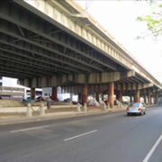
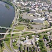
7. Aetna Viaduct-Interstate 84, Hartford, CT
 The elevated portion of Interstate 84 begins at Sisson Avenue and runs through the heart of downtown Hartford, Connecticut. The Aetna Viaduct segment of the Interstate is a three-quarters of a mile concrete separation that divides Hartford pedestrians, as much of the space underneath is unfriendly for walking and biking and mostly utilized as surface parking, but also caused the loss of historic architecture, identity, and severed connections between the neighborhood and public spaces of Asylum Hill, isolating downtown growth for years to come.
In 2005, the viaduct of I-84 reached the endpoint of its 40-year lifespan and the City of Hartford was left at a turning point of how to address the structure, which bolsters roughly 175,000 travelers per day: repair any damage to the structure to provide another 20 year span of existence or pursue new alternatives that would heal and reconnect downtown with the rest of Hartford. The Connecticut Department of Transportation originally proposed to invest $100 million into resurfacing the aging structure, but stakeholders voiced their opposition, urging the City and ConnDOT to change their course of action.
After securing federal funding, the City hired Goody-Clancy to perform an alternatives studyof the viaduct and noted that while it is in need of immediate repairs, it will also need to be fully reconstructed or replaced within 10-15 years. Active citizens from Asylum Hill and other affected neighborhoods, with the support from the Mayor Eddie Perez and the Connecticut Department of Transportation, joined together to form the Hub of Hartford Committee to represent and enforce the removal of the Aetna Viaduct. The Capitol Region of Council Governments is working closely with the Hub of Hartford and is representing the initial phase of this project on behalf of the City of Hartford.(Image: The Aetna Viaduct. TSTC.)
8. Oak Street Connector-Route 34, New Haven, CT
 Ironically nicknamed, the Oak Street Connector begins at the junction of Interstates 95 and 91 and extends on columns into downtown New Haven for 1.1 miles before dropping to grade and continuing as a pair of one-way streets, with 73,900 vehicles traveling on the route per day. Built in 1959, the Connector was an urban renewal project, occupying 26 acres of land between downtown and the nearby neighborhood. The original plan was to extend the road another 10 miles, but that long section was never accomplished, resulting in the displacement of 600 families and 65 businesses to make room for a highway that was never completed, destroying the vitality of surrounding neighborhoods and significantly increasing poverty rates within the area.
In 2002, the State of Connecticut sold off the land that had been set aside for the extension of the Oak Street Connector. In 2005, with the completion of Pfizer Pharmaceutical's research facility in the former planned right-of-way, the City of New Haven and local civic groups began calling for the replacement of the Oak Street Connector with a four-lane boulevard. A concept plan developed identified 10 acres of vacant land to redevelop and two street connections to restore, along with a larger surrounding area to be revitalized. New Haven's Mayor, John DeStefano, Jr. included the removal of the Connector in Future Framework 2008 as an urban infill strategy. The Tri-State Transportation Campaign and the Urban Design League of New Haven have been actively campaigning for the replacement of the elevated and paired one-way sections of Route 34 with walkable, pedestrian-friendly streets and blocks.
In early 2010, Mayor DeStefano announced the initial phases of the removal of Route 34 , starting with 100 College Street, in his address to the City. Although they were not awarded funding for their proposal through this year's round of TIGER grants, the Mayor promised to find resources to make the project become a reality. Work on this portion of the highway is slated to begin late this year or early 2011. (Image: Route 34 as it dead ends underneath a parking garage (lower left). GATM.com
9. Bonaventure Expressway, Montreal, QC
 Built seemingly in haste as a complement to the Champlain Bridge and as the main thoroughfare for the 1967 World's Fair, the Bonaventure Expressway was built in 1960s to ensure traffic into downtown Montreal due to the delay of the Ville-Marie Expressway. Despite the Expo's considerable success, the Bonaventure Expressway was left nearly useless following its end, ensnaring future waterfront development and ultimately paving the way for an auto-oriented downtown. Today, the expressway is lightly used with 58,000 travelers per day, is "a drab entry point for motorists arriving from the South Shore, a no man's land for pedestrians at ground level, and an unattractive zone for developers" (Montreal Gazette).
The Société du Havre de Montréal (SHM) is a non-profit organization that formed in 2002 to oversee the development of the Montreal harborfront and guarantees it will become one of the main engines of the Montréal economy once again." The SHM, working with Montreal 2025implemented feasibility reports back in 2003-2004 to look into the benefits of removing the elvated portion of the Bonaventure Expressway to an at-grade boulevard. Both SHM and Montreal 2025 agree that removing the expressway is the best alternative to launch the reunification, on a humanscale, of the downtown area with its river. In addition to improving the waterfront development, according to the SHM's summary of the project, the new boulevard will enhance the main gateway to the Centre des Affaires [business centre], extend city centre functions and help rebuild the surrounding areas, while at the same time increasing the City of Montreal's tax base.
As listed by ProjetMontreal, the demolition of the first 800 metres, from the Peel Basin to Notre-Dame Street is scheduled for this year. The plan is then to demolish the remaining elevated section and reestablish the highway link with the construction of a tunnel under the Peel Basin, investing a light rail link between downtown and the South Shore. Following the findings of the feasibility studies provided by SHM will restore Montreal's harborfront, bringing the success the City saw during Expo 67, but this time sustaining itself into for years to come.
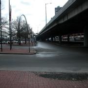
10. Interstate 81, Syracuse, NY
 Another victim of the Interstate Highway System, the construction of Interstate 81 (I-81) in Syracuse in 1957 destroyed a historic black community, ruined the economic activity within the area, and caused major barriers to development ever since. Roughly 75,000 vehicles a day use I-81 as it runs just east of downtown and connects with I-690. As with many structures from this era, this six-lane structure is near the end of its design life and more attention is being paid to the negative effects that I-81 brings to downtown Syracuse.
In 2001, Syracuse Common Councilor Van Robinson called for the removal of elevated portions of the interstate. Leading figures from Syracuse University and Upstate Medical University, who see I-81 as an eyesore and impediment to the growth of their respective institutions, have also joined the fray with support for removal. Robinson envisions nearby I-481 as the main carrier for through-traffic, while elevated I-81 would become an urban boulevard. The Syracuse Metropolitan Transportation Council and the New York State Department of Transportation (NYSDOT) are co-leading a multi-year study to review potential alternatives and analyze traffic with input from the public. Additionally, the Onondaga Citizens League conducted a study entitled " Rethinking I-81," which will focus on the social, economic, and cultural effects of possible alternatives. In early 2010, the decision over what to do with the structure remains an issue of major debate, especially among commuters, in Syracuse. The SMTC is offering reassurance that no matter which option they choose for I-81's fate, the plans will be carefully studied and crafted to suit the citizens of Syracuse. (Image: I-81 bisecting Syracuse neighborhoods. Syracuse.com .)
11. Route 29, Trenton, NJ
 In the 1950s, the northern section of Route 29 was designed for speed by engineers with long stretches of straightaway and slightly larger lane widths. It converted to a limited-access, four-lane highway along the Delaware River. The road carries 60,000 vehicles per day and the extra wide, extra straight lanes encourage drivers to speed, ultimately leading to a higher than average rate of collisions. Back in 1989, Duany Plater-Zyberk's Trenton Plan re-envisioned this area as a mixed-use waterfront neighborhood.
More recently, the State of New Jersey's Capital City Redevelopment Corporation (CCRC) started investigating how to convert 1.8 miles of the highway into a boulevard complemented by an improved street grid, which would get 90 percent of the area's 32 acres back on the tax rolls. The conversion has been on the NJDOT's list of projects for several years under its integrated land-use and transportation docket. But with funding shortfalls, the NJDOT hasinformed the city that it will have to come up with its own funding. The City of Trenton and the Capital City Redevelopment Corporation are not giving up, however. A new park is under construction and the project includes one of the new perpendicular city streets that will eventually connect to the boulevard. In May 2008, the partners released a request for proposals for a market feasibility study that is aimed at bringing in a master developer for the site. The Tri-State Transportation Campaign has followed this project through the years and continues to help in advocacy efforts.
In 2009, "the city of Trenton signed a memorandum of understanding (MOU) with virtually every county, regional, and state agency that has a say in the roadway’s future. The MOU expresses the commitment of the agencies to replace Route 29 with a boulevard and waterfront park that will promote development and create better pedestrian and car linkages between the waterfront and the rest of the city." Also, CCRC participated in a local effort called "Beautiful Trenton" and submitted a piece reflecting the vision of a new waterfront and the positive aspects that would benefit Trenton residents with the removal of Route 29. (Image: Route 29 effectively blocking the city from waterfront development.Beautiful Trenton.)
12. Gardiner Expressway, Toronto, ON
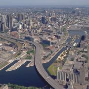
 Built between 1955 and 1966 by the Ministry of Transportation of Toronto (MTO), Toronto's Frederick G. Gardiner Expressway is a major east-west thoroughfare that connects downtown Toronto to its western suburbs. The girth of the Gardiner's elevated eight lanes separates the city's bustling core from its Lake Ontario waterfront. What was originally built to accommodate 70,000 cars daily now carries around 200,000 and costs $6 to 10 million annually in repairs.
For years, citizens of Toronto have called for the removal of the elevated expressway as it runs from downtown eastward. And they've had some success. A far eastern portion of the elevated freeway, which had been left a stub following a citizens' revolt, was successfully removed in 1999. WATERFRONToronto, an economic development corporation, has called for a partial teardown of the expressway and the building of an eight-lane urban boulevard in its place. On July 15, 2008, the City's Executive Committee approved an $11 million environmental assessment project that is a major first step in removing this 1-mile portion of the freeway between the Don Valley Expressway and Jarvis street. Depending on how the eight lanes are designed, this project has the potential to create a more walkable environment. Toronto Mayor David Miller believes that freeway teardown to be "the most practical approach and offers the greatest public benefits." (Image: Nelson Cruz.)