


Ramming freeways through city neighborhoods did astronomical damage to cities in the 20th Century and continue to burden communities with the significant health hazards of vehicle exhaust, a loss of local businesses and services, and streets that are hostile to pedestrians. Many of these freeways could be removed and replaced with surface streets or capped. Whenever this has happened—whether in San Francisco, New York City, Rochester, Milwaukee, or Seoul, South Korea—the city always has improved economically and environmentally. In short, freeway removals, halts to expansion, and highway caps reduce state and federal infrastructure costs while boosting local economies by strengthening urban places and are a win-win for in-city transformation.
We are at a time where much of this infrastructure is nearing the end of its functional life. Now is a great opportunity to choose differently and learn from the successful examples of replacement of in-city highways with street networks and caps. The campaigns featured in this report illustrate the evolution of the Highways to Boulevards movement and envision reparative infrastructure that reknits communities, addresses the damage caused by these highways, and centers community priorities.
The 2025 report exists in a context far different from where this report began in 2007. Thanks to the hard work of local campaigners and the backing of state and federal governments, more and more city highways are being considered for removal. Today’s campaigners can look at the success stories of freeway removals nationwide to inspire change in their communities.
This report nominates nine highly deserving campaigns for freeway removal, either through Reconnecting Communities or other funding mechanisms, and also provides an update on previous nominees, including those that have had success and those that have been supported financially through Reconnecting Communities financing. This report looks to the future of highway removal while reflecting on and celebrating the enormous progress of the Highways to Boulevards movement overall. Media inquiries: Contact Lauren Mayer.
-
I-35 in Austin, Texas
-
NY State Routes 33 and 198 in Buffalo, New York
-
Interstate I-980 in Oakland, California
-
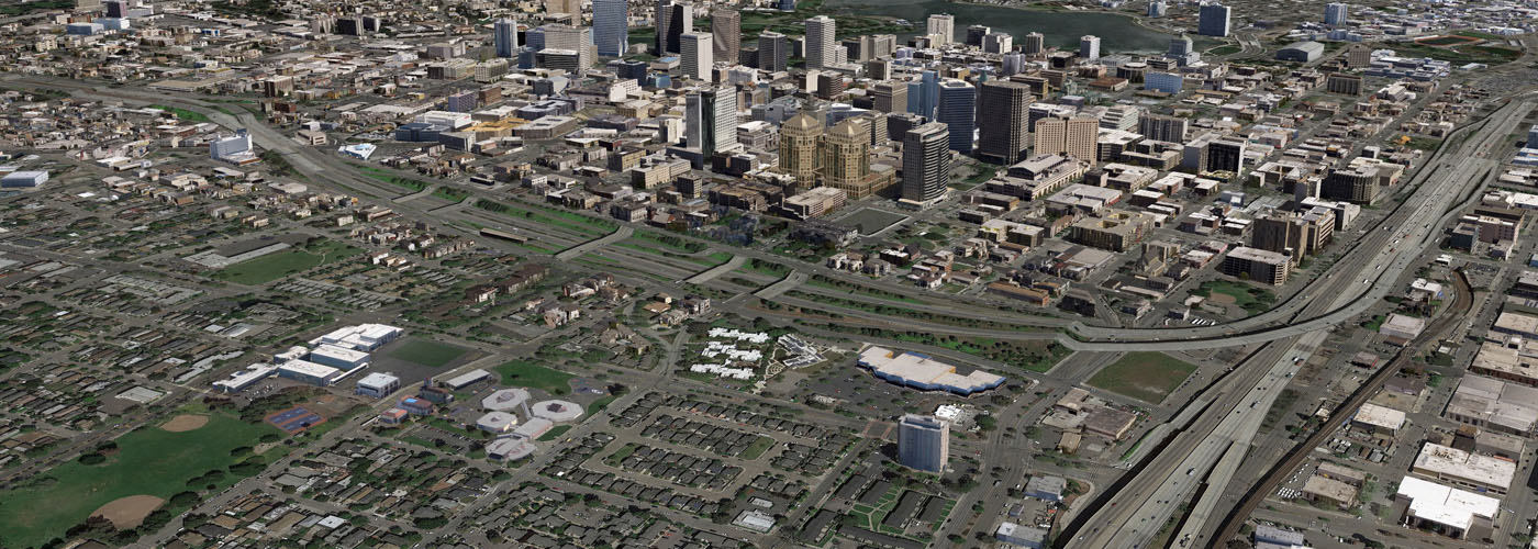
Interstate 45 Expansion in Houston, Texas
-
Interstate 175 in Saint Petersburg, Florida
-
IL 137/Amstutz Expressway/Bobby Thompson Expressway in Waukegan and North Chicago, Illinois
-
DuSable Lake Shore Drive (US 41) in Chicago, Illinois
-
US-101 in San Mateo County, California
-
US-35 in Dayton, Ohio
-
Campaign Updates
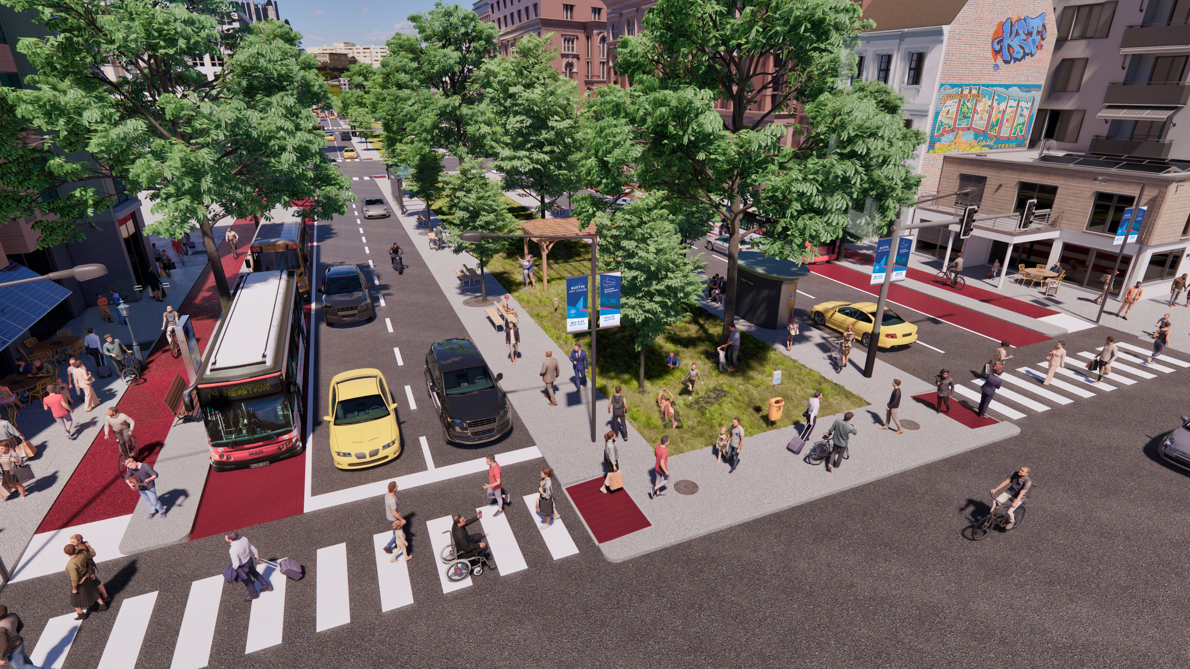
I-35’s location reinforced a racial segregation line that began with Austin’s 1928 Master Plan, forcing minority communities to relocate to East Austin through exclusionary zoning, racist policies, and redlining. Today, I-35 slices through Austin’s urban core, creating a barrier between neighborhoods and producing levels of toxic air pollution that the EPA considers unsafe. In multiple areas, walkable, older neighborhoods adjacent to I-35 are disconnected from each other because of infrequent bridges and underpasses and dangerous crossings.
In a typical year, around a quarter of Austin’s traffic fatalities occur on I-35. In one particularly devastating 17-vehicle crash in March 2025, five people - including a child and an infant - were killed and five more hospitalized in critical condition.
Despite overwhelming opposition to expansion from residents and elected leaders, TxDOT has broken ground on the I-35 Capital Express Central Project, which will expand 28 miles of the highway from 12 to as many as 22 lanes. Two popular local campaigns are advocating for alternatives to expansion. Reconnect Austin proposes sinking and covering I-35 with a boulevard
while Rethink35 advocates for rerouting I-35 around town and replacing the current highway with a boulevard. However, TxDOT refused to thoroughly study either proposal.
Both campaigns have had considerable success in changing local attitudes around I-35 and urban highways in general. Reconnect Austin was founded in 2012 and was the first organization to boldly reimagine I-35 through central Austin, helping the public to understand that a surface-level interstate highway in the heart of the city is not an inevitability and how such valuable land
could be better used for other purposes.
Rethink35 was founded in 2020 and has over 10,000 individual supporters, plus a growing coalition of support from local organizations and businesses. Through coalition-building with diverse organizations, rallies and other events, a high-profile lawsuit against TxDOT, and engaging with elected leaders, they have made significant progress in normalizing opposing highway expansions and envisioning highway to boulevard proposals.
In 2024, the City of Austin received a Reconnecting Communities grant to partially fund the “Our Future 35” project, which would cap portions of I-35 in central Austin with parks and amenities (as of writing, uncertainty at the federal level means receiving the funding is in doubt). Cap supporters argue that capping the highway would provide acres of new centrally located park space, reconnect disadvantaged communities that were separated from downtown Austin when I-35 was constructed, and encourage nearby development to help fund the caps.
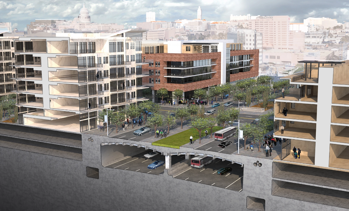
Opponents argue that the caps would cost vast sums (approximately $1.4 billion plus $47m for annual maintenance) and take away limited City funds for other purposes, provide park space of dubious quality compared to other nearby destinations, and that the likely impacts on nearby development are too hard to gauge.
Widespread public outcry about major highway expansions in Austin, other cities such as Houston (I-45) and El Paso (I-10), and an enormous number of other roadway expansions across Texas led advocates to unite to create the statewide Texas Streets Coalition (TXSC). The coalition now provides support to local freeway fighting campaigns and has united groups across Texas to pursue legislative change at the state level to turn away from endless roadway expansions and toward more funding for walking, bicycling, transit, and safety. Sustained advocacy, coalition-building, and funding will be key in the years ahead.
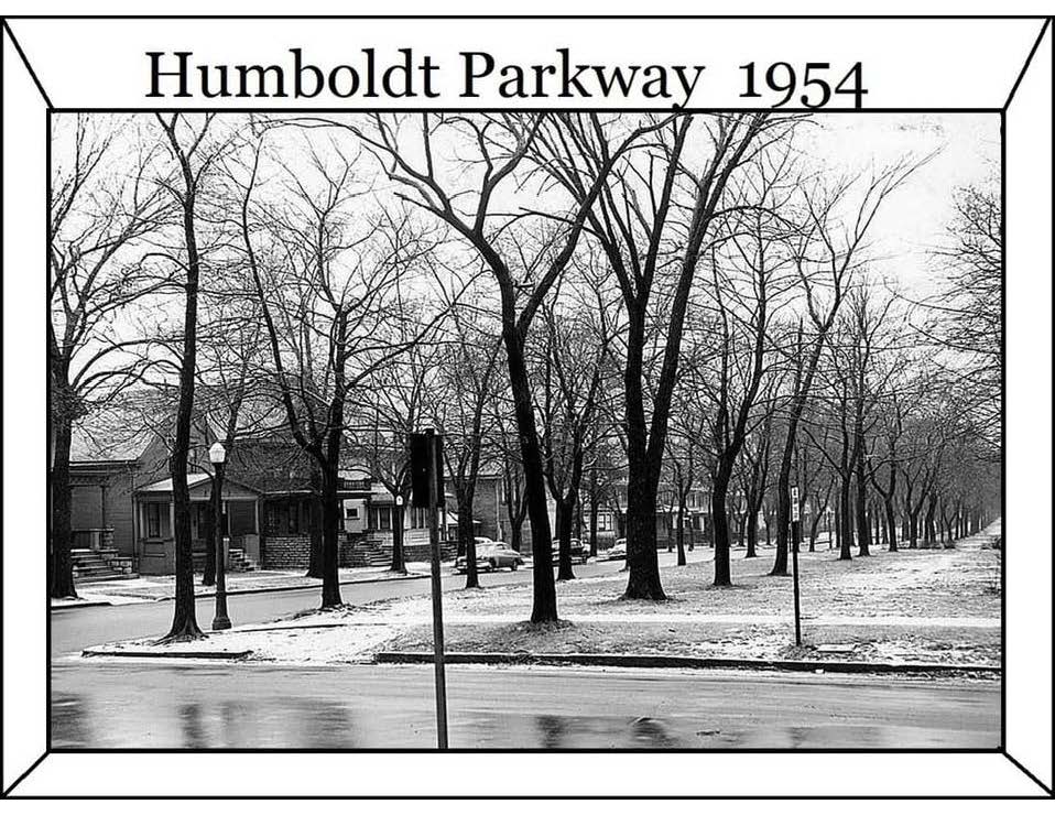
tree-lined Humboldt Parkway in Buffalo, NY.
The roadways were constructed through the 'heart' of the City of Buffalo in both its North Side and its East Side communities, after WWII. NYS Route 33 Kensington Expressway, in particular, is primarily positioned within the municipality’s (predominantly Black or African American) East Side Community. The NY State Route 198 Scajaquada Expressway similarly cuts primarily through the greenery of North Buffalo's majestic Delaware Park, but also pollutes one of Buffalo’s major urban freshwater ways, the Scajaquada Creek. Both highways also divide very highly densely populated residential city blocks. In addition, the 24/7/365 noise and air pollution emanating from the roadways have led to very significantly adverse environmental and health impacts, including inordinate incidence of cancers, heart disease, dementia, low birth weight, and autoimmune disorders. This has resulted in a pronounced public health crisis, with residents also reporting experience of high rates of asthma, lupus erythematosus, emphysema, and other respiratory issues.
In Spring of 2022, the city and state bought into the 're-envisioning' of these problematic routes with federal Reconnecting Communities financing, and with buy-in from the New York State Department of Transportation (NYSDOT), attempted to move forward with a cap and tunnel approach. That vision also included building a small scale park, atop a proposed 3/4 mile tunnel. Unfortunately, the vision put forward by the city and state was at odds with the surrounding East Side community’s vision and goals. These communities' residents chose improvement of their households' opportunity to gain and to enjoy good health, and the restoration of their neighborhoods' Natural 'Great' Outdoors environment. Progressive environmentalism groups such as the East Side Parkways Coalition (ESPC) and its community partner network, including the East Side Collaborative Partnership group, and over 110 member organizations of the well respected regional think-tank organization Partnership For The Public Good, in conjunction with the Scajaquada Corridor Coalition are seeking, instead, the complete removal of the Kensington and Scajaquada expressways. These groups have been highly successful in gaining the support of the overwhelming majority of residents of not only the East Side of the CIty of Buffalo, but also enjoy meaningful support from local foundations, and from a groundswell of residents who live within the city's surrounding suburban 'ring' communities.
In 2024, ESPC was party to no fewer than five lawsuits lodged against NYSDOT, over the NY 33 Kensington Expressway Project. The New York State Supreme Court has consistently ruled
in ESPC’s favor, including that NYSDOT must complete an Environmental Impact Statement, which the agency did not initially furnish for their proposed ‘cap’ and tunnel design. Moreover,
the expressway’s massive retaining walls are far beyond repair, and their removal and replacement are expected to increase the release of GHGs, as well as also involve the release of several hundred thousand metric tons of asbestos. All the above factors would further exacerbate the East Side Buffalo community’s polluted air. NYSDOT’s Kensington Expressway Project is currently under an injunction, issued in New York State Supreme Court. One of the primary conditions of the injunction is that the agency now completes an EIS.
These lawsuits involve over 60 Humboldt Parkway neighborhood residents as plaintiffs and other Upstate Western New York advocacy groups, such as Racial Justice Center of the New York Civil Liberties Union, and WNY Youth Climate Council. The case for freeway removal for NY State Routes 33 and 198 demonstrates how the work of local removal campaigns like Restore Our Community Coalition (ROCC) and ESPC can evolve over time. Both the Kensington and Scajaquada expressways have been nominated for multiple Freeways Without Futures reports as community stakeholders have been vocal that the removal of these freeways goes beyond getting rid of dangerous roadways; rather it is a step toward realizing Buffalo’s future potential and increasing its residents’ quality of life. Numerous regional assets are located along the corridor and are currently separated by the highway, including many of Western New York’s key cultural and educational institutions and the suppressed Scajaquada Creek.
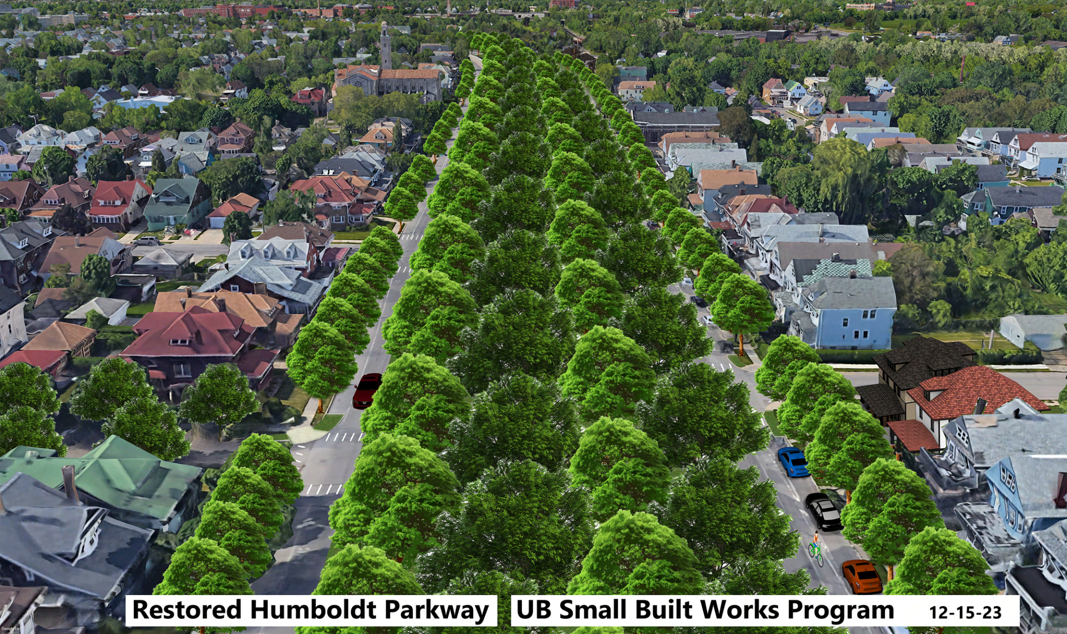
In response to the ‘toxic tunnel’ proposal, ESCP and stakeholders have countered with full removal proposals to restore the parkway environments designed by landscape architects Frederick Law Olmsted and Calvert Vaux. Removing the highways and replacing them with a street grid, boulevard, and green space would improve air quality, reduce noise, and decrease health issues like asthma. It would also restore neighborhood connectivity, make public spaces more accessible, and increase opportunities for safe, walkable areas. Aware of the impacts a full removal could have, the campaign is looking towards community land trusts to control land costs, inclusionary zoning to ensure affordable housing options, and property tax caps to limit rising taxes for long-term residents. Rent stabilization, affordable housing development, and an anti-displacement fund can also help maintain affordability and protect current residents from being priced out.
Highways like the Kensington and the Scajaquada, all across the United States, have not only deteriorated their surrounding neighborhoods' physical environments, they have also compounded this nation's deeply entrenched socioeconomic challenges, contributed to minority communities' health disparities, and devastated urban USA neighborhood property values. Furthermore, tunnel projects like those proposed for the Kensington and Scajaquada expressways in Buffalo leave great swathes of such roadways' impacted
The currently paused “cap” is not the type of highway removal the local community is looking for. A full removal covers a wider area and would provide Buffalo residents with many benefits such as tree-lined parkways restored, shaded public areas returned, neighborhoods repaired, and public health improved by reducing high rates of lung diseases along the highway. Even more, redirecting traffic through the original street grid would in turn encourage development in these currently overlooked areas. The continued pressure on NYSDOT to truly remove and reknit these communities is vital to a true successful removal and the hard work being done in Buffalo to realize this community vision will have impacts for years to come both locally and for campaigns doing similar work nationwide.
African American by the 1940s, when redlining and urban renewal were used as justifications to divide the community with massive infrastructure projects.
Even though the construction of I-980 was partially halted in the 1970s, most of the right-of-way had already been cleared, leaving a no man’s land separating parts of primarily Black West Oakland from the rest of the city. In 1977, Caltrans restarted the construction of I-980, but residents were able to get some concessions in the form of new housing and rent protections. The freeway’s construction displaced thousands of residents, disrupted longstanding community networks, and imposed a physical barrier that separated West Oakland from the economic and social opportunities in the rest of the city.
The impact of I-980 on African American residents was profound and multi-faceted. Families and businesses were uprooted, reducing homeownership and eroding generational wealth. The freeway also contributed to significant environmental injustice, exposing residents to higher levels of air pollution and noise, which have long-term health implications. The ongoing Vision 980 Study aims to address these harms by exploring potential alternatives to the freeway, such as redesigning or replacing it to restore community connectivity, support economic development, and promote environmental justice for West Oakland residents.
Vision 980 imagines a restorative framework that provides a range of new community-dictated harm repair initiatives and land use opportunities for legacy residents and newer residents. Harm repair initiatives can include housing preference policies, economic development and workforce initiatives, tax increment financing, cultural preservation programs, and other anti-speculation
legislation. Additional community benefits could include mixed-use housing, open space, business attractions, and cultural tourism.
Phase 1 (Spring 2024 – end of 2025) will identify a new community vision, relying on robust collaboration and outreach to partner agencies, community organizations, and the public. To assist with this work, Caltrans is contracting with WSP, which includes the subconsultants RBA Creative, and Arup. and the community-based organizations, Urban Strategies Council, West Oakland Environmental Indicators Project (WOEIP), West Oakland Health Council (WOHC), Phase 1 is funded with a Federal State Planning & Research (SP&R) grant of $500,000.
Phase 2 (early 2026 – late 2027) will include a deeper feasibility analysis of the vision developed in Phase 1. This work will include refining conceptual alternatives, forecasting and modeling, equity assessment, concept evaluation, conceptual design, cost estimates, coordination with other plans, phasing, and funding strategies. Phase 2 is funded with a Federal Reconnecting Communities Pilot (RCP) grant of $680,000 and matching state funds of $170,000.
Some of the possibilities for the future of the corridor may include:
- Increasing housing supply and economic opportunities near the corridor
- Capping the freeway to expand open space and decrease pollution
- Improving public transit connections along and across the corridor
- Redesigning roadways and over/underpasses for people walking, biking, and taking transit along and across the corridor
- Transforming the freeway to create new land use opportunities.
The reimagination of the I-980 freeway will provide regional benefits by linking downtown Oakland, Jack London Square (a major tourist destination), and the historic 7th Street corridor in West Oakland, formerly known as the Harlem of the West. This could have a positive economic impact on West Oakland and attract visitors from across the region, as the freeway corridor is adjacent to one of the most traveled transportation hubs, the West Oakland BART Station, one stop from Downtown San Francisco.
Learning from past oversights, the Vision 980 Study will help ensure that legacy families, some of whom lost their homes and businesses, are empowered in the planning and design process that is vital to truly reconnecting this overburdened community.
This rail system supported the growth of nearby neighborhoods, like Independence Heights and Near Northside, fostering economic activity and community cohesion. When the rail line was replaced by I-45 in the 1950s and 60s, it dramatically altered these communities. Homes and businesses were demolished to make way for the new highway, leading to extensive displacement
and physical division of these neighborhoods.
The highway’s construction also brought significant environmental impacts. For decades, residents in areas like Near Northside, Fifth Ward, and Independence Heights have faced elevated levels of air pollution from vehicle emissions, contributing to higher rates of asthma and respiratory illnesses. Noise pollution from traffic and construction has become a constant strain on community well-being. The concrete infrastructure has worsened stormwater runoff, contributing to flooding issues that continue to plague these areas. Increased concrete and impermeable surfaces prevent natural drainage, leading to localized flooding, which threatens homes and public health—especially for those who lack resources for flood mitigation.
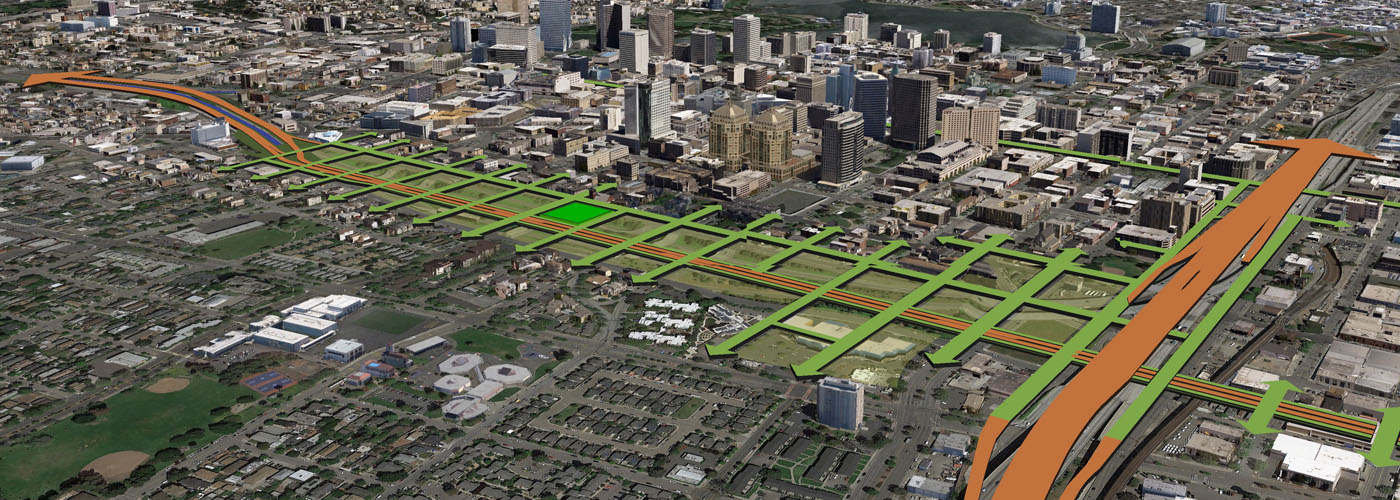
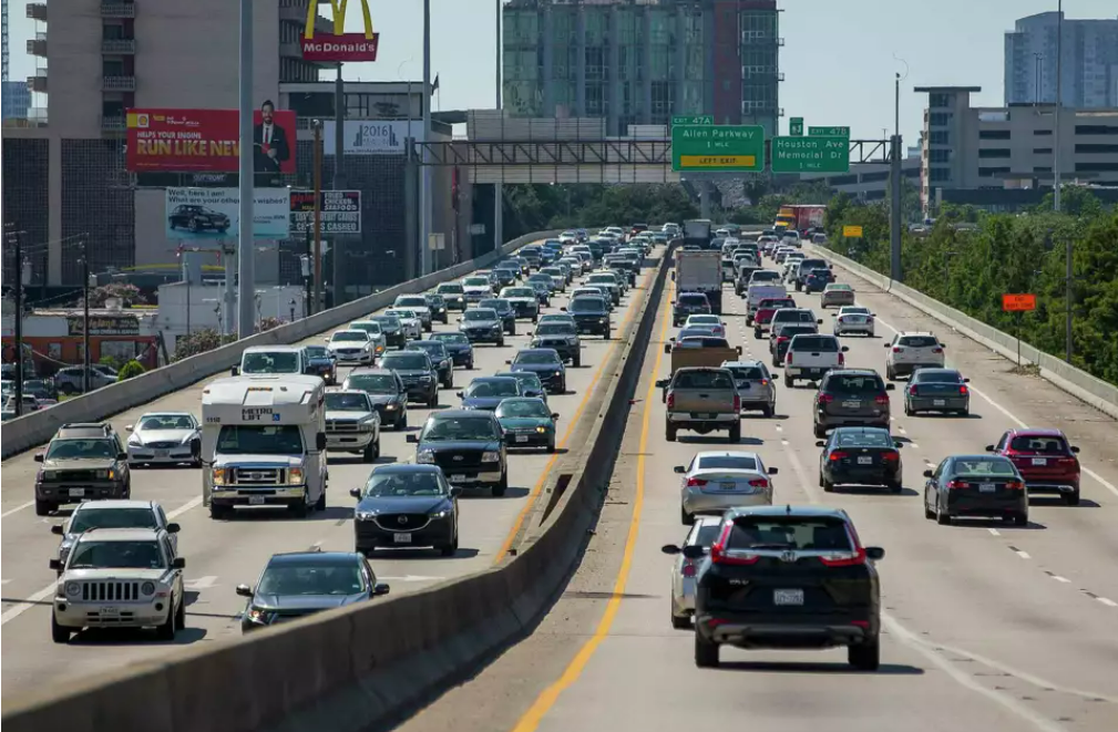
The grassroots campaign, STOP TxDOT I-45, is fighting the North Houston Highway Improvement Project (NHHIP), which threatens to worsen the environmental destruction already impacting Houston. The expansion would directly contribute to the loss of our historic bayous, destroy flood-absorbing land, and increase concrete sprawl— worsening air pollution, flooding, and heat island effects. These harms fall hardest on Houston’s Black and Hispanic neighborhoods, which have long borne the brunt of environmentally racist infrastructure decisions. STOP TxDOT I-45 and its allies are demanding a halt to the expansion and advocating for solutions that prioritize people, protect our environment, and build true resilience.
This grassroots campaign introduces a new approach to the Freeways Without Futures report by spotlighting the environmental and community benefits of stopping the highway. Redirecting NHHIP funds toward people- centered investments could transform transit access, restore green spaces, and create healthier neighborhoods across the city. During his time as Mayor of Houston, the late Congressman Sylvester Turner proposed Vision C—an alternative to NHHIP that embraced equitable public transit and environmental sustainability. But TxDOT never took the proposal seriously, and today there is no political will to pursue it. This campaign calls for a renewed commitment to community-led planning that preserves Houston’s natural landscape and supports its most vulnerable residents.
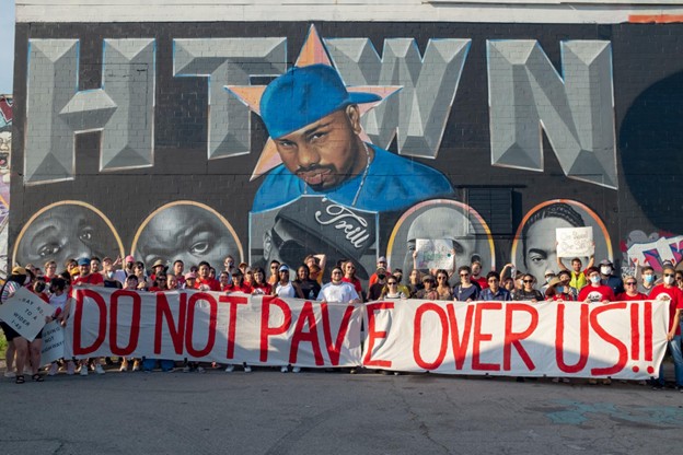
By advocating for these strategies, the STOP TxDOT I-45 campaign aims to protect current residents from the adverse effects of the highway expansion, ensuring that the community remains inclusive and affordable for all. These include economic benefits, environmental benefits, and economic benefits linked to environmental improvements. Here are some key points highlighting how halting this highway expansion could benefit the legacy community:
- Investment in Multimodal Transportation: The $13 billion allocated for the NHHIP could instead be redirected toward a variety of multimodal transportation projects. This could include enhancements to public transit systems, expanded bike lanes, and improved pedestrian pathways, making it easier and safer for residents to travel without relying on cars.
- Reduced Displacement: The expansion of I-45 threatens to displace 1,079 multifamily homes, 334 businesses, 2 schools, and 5 places of worship. Not building the highway would protect these community assets, preventing the upheaval and loss of homes, schools, and vital community spaces that support social and cultural connections.
- Environmental Benefits: Halting the highway expansion would help prevent a cascade of environmental harm that disproportionately affect Houston’s most vulnerable communities. A people-first, environmentally conscious approach would make Houston more resilient to climate change while creating a more livable, equitable city for future generations.
- Community Resilience: Redirecting funds toward infrastructure improvements that prioritize community resilience—such as flood management systems and climate adaptation strategies—would strengthen neighborhoods against environmental challenges, including flooding and extreme weather events.
- Economic Opportunities: Investing in public transit and multimodal options can create jobs, stimulate local economies, and promote equitable access to employment opportunities. Improved transportation options can connect residents to jobs, education, and services, fostering economic growth in the community.
- Enhanced Quality of Life: Ultimately, not building the highway would allow for the development of spaces that prioritize community well-being, health, and connectivity. A focus on pedestrian-friendly designs, public parks, and community centers can contribute to a higher quality of life for residents.

and its medical facilities. However, its construction led to the displacement of over 4,000 residents, primarily from Black neighborhoods, and severed connections between downtown and the Southside.
Crashes on feeder one-way streets account for a disproportionate amount of injury and death. The highway has created physical and socio-economic barriers, contributing to economic disinvestment in south St. Petersburg, increased pollution, and diminished quality of life for adjacent neighborhoods. Today, it is underutilized at 40 percent capacity and in need of costly repairs, prompting a community-led movement to replace it with a boulevard that would reconnect neighborhoods and stimulate local economic growth.
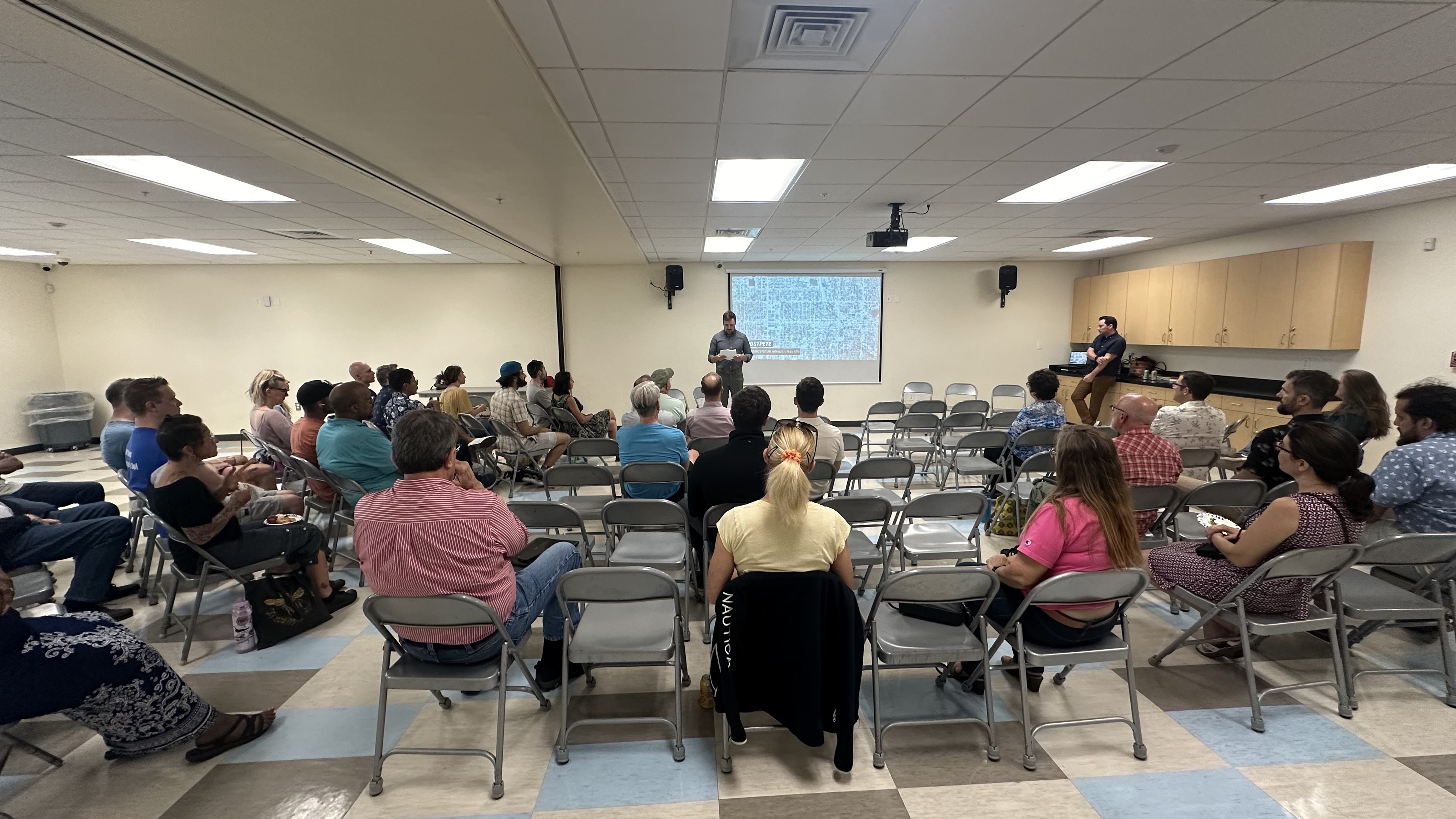
The city completed a mobility study of its downtown street network and labeled reconfiguration of 175 as a priority one project. From there, the MPO Forward Pinellas recommended a feasibility study and FDOT has funded an $800,000 feasibility study of different options including a viaduct, a cap, a boulevard, or leaving the highway in place. Reimagine 175 is advocating for the Boulevard option as it provides the most benefits for St. Petersburg communities.
This local campaign has met with and presented to neighborhood associations, met with innovation district, chamber of commerce, city council members, and spoke with the Rays/Hines developers that will be developing the new baseball stadium and mixed-use development adjacent to this highway. They are beginning to present at faith-based organizations and training
more presenters to continue outreach.
For half a mile the only access to cross this road is a dangerous underpass, an aging and steep pedestrian overpass covered in barbed wire, or an overpass with narrow sidewalks. A boulevard offers the most benefit as it would allow for the street grid that once existed to be reconnected. Reclaimed land taken from black families (20-30 acres) would be able to be used for affordable and mixed-use housing development in a densely developed county facing a housing crisis. From the outset, Reimagine 175 has acknowledged the risks of displacement with the highway’s removal and has plans in place for a community land trust.
Replacing 175 with a boulevard is the only viable option to address the concerns and needs of the community. Mobility would improve as transit users and micromobility is negatively impacted by the barrier wall created by the highway, and a connected street grid would make access to economic opportunities easier for folks living south of the highway. This campaign was spurred by the availability of local government interest and financing in the form of a feasibility study and is working to ensure the boulevard option is fully considered in order to reconnect historically marginalized neighborhoods, promote economic growth, and address harmful environmental and social impacts caused by the highway.
Bobby Thompson Expressway
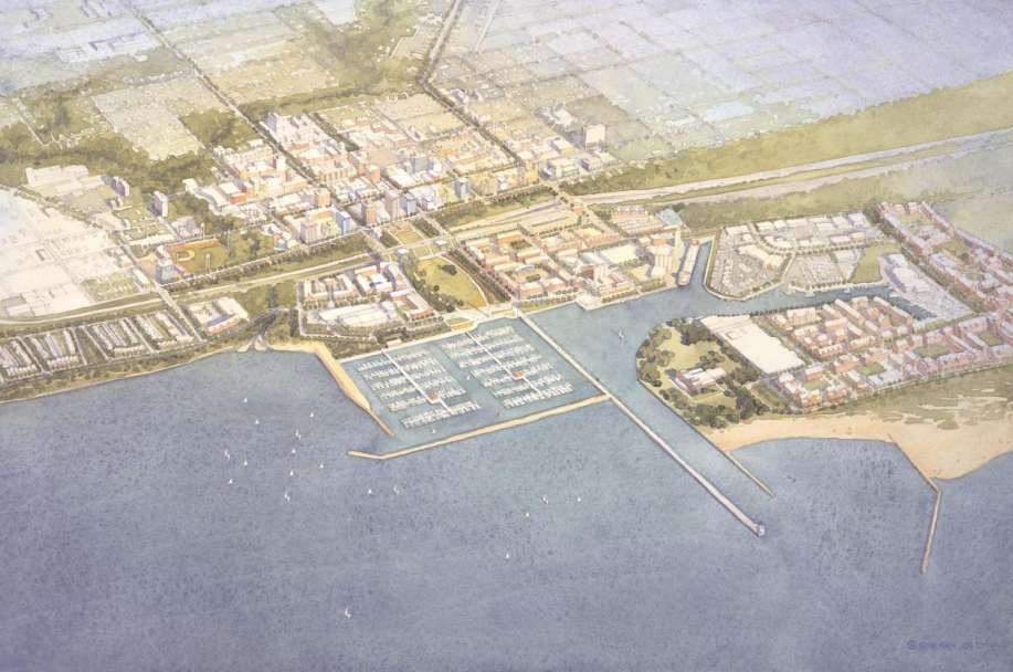
Though IDOT built the portions in Waukegan and North Chicago, the planned extensions were never built, and the lakefront industries the expressway was built to serve have since left. What remains is an overbuilt road to nowhere that diverts traffic and visitors away from the cities’ downtowns and separates the communities from their lakefronts. In addition to restricting access to the lake, the lack of connectivity has also been a barrier to the transformation of the lakefront areas into the mixed-use, transit-oriented developments envisioned by the cities’ master plans.
Initiated by the Cities of Waukegan and North Chicago, the IL 137/Sheridan Road Corridor Project has received partial funding for the feasibility study through an Illinois Statewide Planning and Research Funds (SPR) grant. This study builds on the 2003 Lakefront Downtown Master plan that provides three alternative designs for a reimagined Amstutz Expressway. The vision for the project includes a removal of the southern portion of the Amstutz, a capped park extending over the portion of the corridor in downtown Waukegan, and a boulevard to replace the northernmost portion. More connections and grid alignment throughout will be considered. The ultimate design will weigh the recommendations of the studies with the visions presented by the community.
The community needs a transportation system that serves their transportation needs. The combination of removal and “boulevarding” the Amstutz will provide a right-sized road for the relatively low Annual Average Daily Traffic (AADT) count of approximately 5,750 that currently occurs on the corridor, a number that has decreased over the years (source: IDOT 2023 AADT map). A road with this design and designation would typically carry up to four times as much traffic. In addition to the benefits of improved connectivity and access to resources, a smaller road will be less
costly to maintain and provide an aesthetic improvement for commuters and neighbors.
The capped park will extend over a block-size portion of the corridor from downtown Waukegan to the waterfront, adding needed green space to the downtown while providing a seamless pedestrian connection from the bustling economic engine of the city to its most precious resource. The areas created by the removed highway will follow community-inspired design guidelines
from the cities’ master plans and will be designed to integrate into the community.
In addition to recognizing the displacement caused by the construction of the Amstutz, the City of Waukegan is conscious of the threat of displacement posed by highway removal. In a similar manner, they are aware of the blight caused in part by the highway’s construction and will focus all future developments on the corridor to reverse that damage and raise property values sustainably. Quality of life will increase but not at a level that displaces current residents. Development in newly opened land will be on City-owned parcels where the city has control over development, so proposals will need to integrate into the existing environment and must win the support of the community to be approved. These developments will fill the “missing middle” that exists in Waukegan’s current housing stock. The inclusion of anti-displacement matters has been emphasized in grant applications and its consideration will be required in all stages of development.
Expressway removal would immediately benefit residents with improved connections to the lakefront, Waukegan Harbor and Marina, Waukegan Metra Station, and Waukegan Municipal Beach. The improved grid connections would restore the neighborhood fabric and give residents of Waukegan easier access to jobs, healthcare, local businesses, and recreation spaces. Lower speeds along the corridor will reduce exhaust and noise pollution, improving the health of an environmental justice community. In the long term, as a result of the increased development space, residents of the area will benefit from an increased tax base that will improve their municipal services and prevent a higher tax levy. Lastly, the removal of the Amstutz will boost community positivity by achieving a long-held goal of the cities. The overbuilt and underutilized road is an embarrassment to the community that has become a monument to Waukegan’s economic decline.
As cities deal with the harmful impacts of legacy highway projects, robust community engagement that acknowledges the historic unequal burdens of these expressways, while envisioning an equitable and sustainable future, illustrates how the Highways to Boulevards movement maintains its nationally recognized status and serves as a framework for cities to improve their street networks nationwide.
(US-41)
(Chicago’s first non-Indigenous resident; a man of African descent) in 2021.
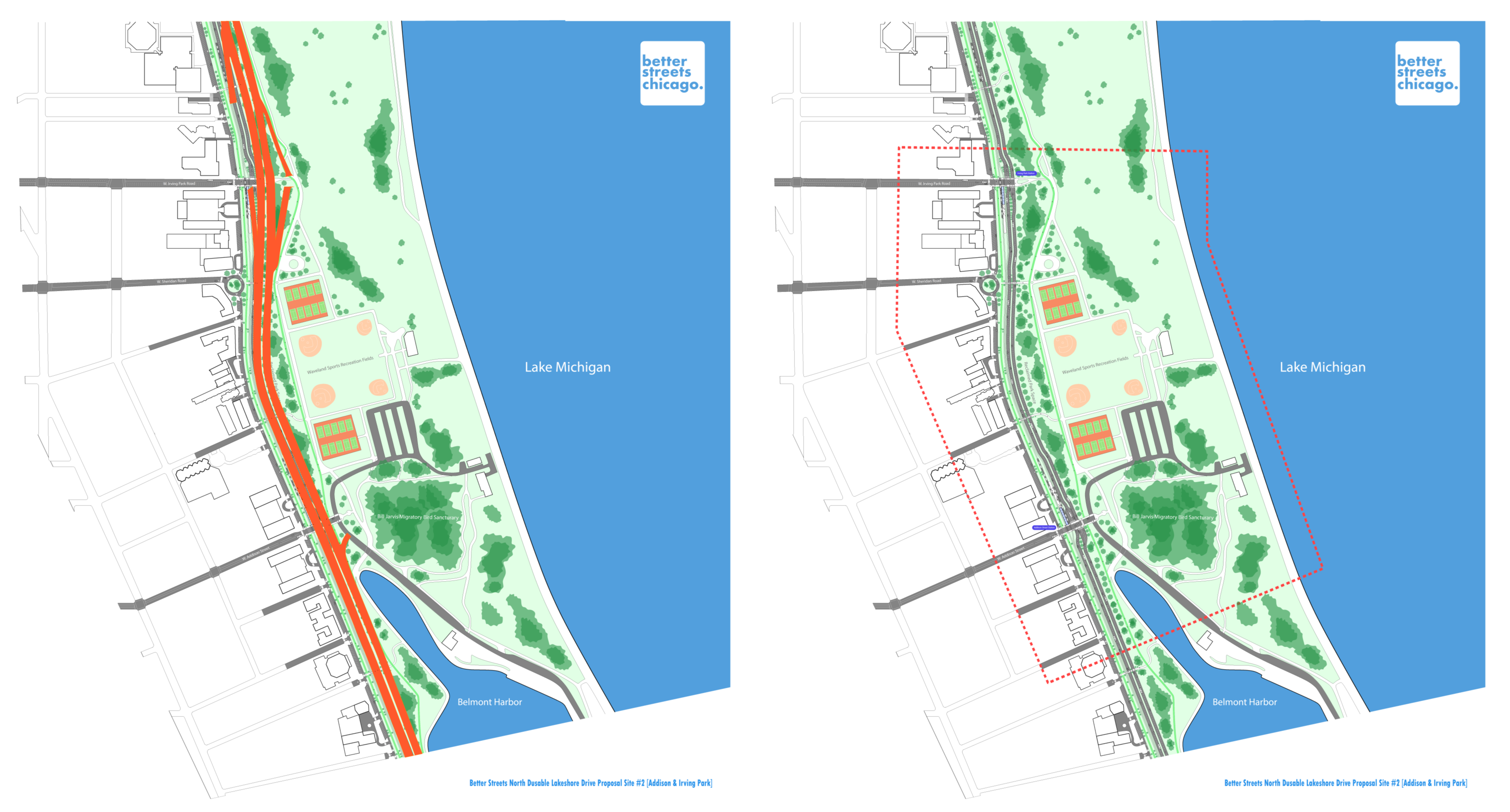
The DLSD is an eight-lane wide highway that runs 15.8 miles from Hollywood Avenue in the Edgewater neighborhood on Chicago’s North Side to 63rd Street in the Jackson Park neighborhood on the South Side. Initially, the road was intended for leisure drives through the new lakefront parks, in a right-of-way much narrower than exists today. “The Drive,” as it’s colloquially called in Chicago, runs parallel to the iconic Lake Michigan shoreline for its entire length, and mostly adjacent to or through the city’s many lakefront parks, including Lincoln Park, Grant Park, Burnham Park, and Jackson Park.
The road was ultimately transformed into an expressway following the rise of widespread private automobile use starting in the early 20th century. It is widely viewed as a noisy, dangerous, and polluting barrier between the city and its greatest natural resource, geographic feature, and public space.
The Illinois Department of Transportation (IDOT) is leading the Redefine the Drive planning project, which is a proposal to enlarge DLSD and rebuild it to interstate-grade expressway standards. The project is mired in accusations of ignoring community feedback and obfuscation. The process is widely and credibly understood as being designed to produce a predetermined proposal to rebuild the facility as a fully-fledged expressway. This is in spite of ongoing and growing community opposition.
Better Streets Chicago (BSC) laid the groundwork for the Save the Lakefront coalition to take shape and has actively led advocacy efforts since it was established, including extensive community outreach and coalition building efforts. These efforts enabled a coalition to take shape quickly following the 2024 announcement by IDOT and CDOT of a preferred design alternative. Individual
community members, stakeholders, advocacy organizations, and elected officials have expressed deep concern about and outright opposition to keeping DuSable Lake Shore Drive an expressway as the proposal has few champions outside the state and city DOTs. BSC is presenting an alternative vision for transforming DLSD into a boulevard to reduce travel speeds, increase safety, encourage mode shift, prioritize transit, and improve conditions for pedestrians and cyclists. There is consensus that the corridor should be rebuilt accordingly.
Transforming DLSD into a boulevard, reducing DLSD from eight lanes to four in both directions, would have a massive and positive impact on Chicagoans. It would enable people to safely access the lakefront and comfortably enjoy the park as a serene public space. A successful transformation would necessarily require a massive investment in transit, which when done right should and can connect a much more diverse array of neighborhoods, including many on the South Side that currently lack adequate connections. A key goal of BSC’s advocacy is to plug work seeking to transform DLSD from an expressway into a boulevard with other efforts that reduce residents’ need to own and/or use a car for many trips.
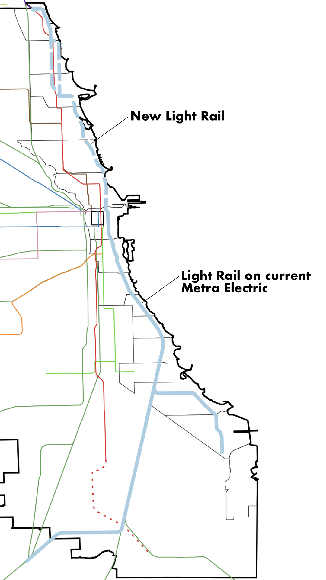
By removing grade separated junctions, retaining a mix of at-grade pedestrian crossing at junctions, and retaining a mix of over and underpasses, the design improves lakefront access. By reducing the overall footprint and vehicle lane widths, the design reduces speed and increases safety, especially for park users. Slower speeds and fewer vehicles would likewise reduce noise pollution and other forms of vehicle pollution. The reduced footprint could also enable the expansion of the lakefront parks by anywhere from several dozen to over 100 acres across the system. This would greatly improve the city’s ratio of parkland to residents, which is notoriously low.
Removal would greatly reduce congestion in Chicago, in particular in the downtown area and densely developed North Side neighborhoods, which are really struggling with congestion. It would also improve the city’s standing as a tourist destination, which is a rapidly growing industry in the city.
Furthermore, by not rebuilding DLSD as an expressway, the city and state could reduce project costs by a billion dollars or more, stretching overall public investment. Resident access to jobs centers on the North and South Side would be greatly improved; this is particularly the case for the South Side, which is about to receive significant investment in high tech industrial centers near the lakefront and Port of Chicago. A complete, independent economic impact analysis is currently underway to shed more light on the impact in this area.
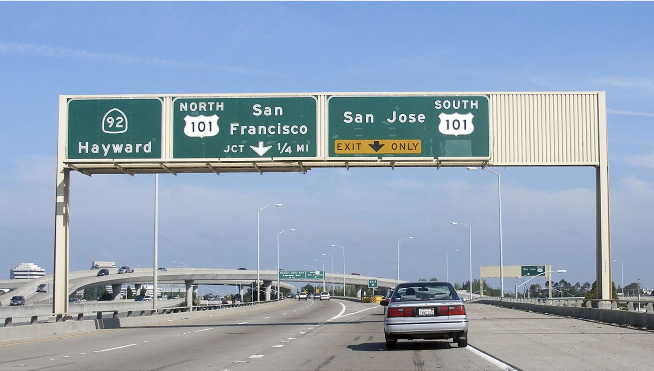
The area adjacent to the US-101 highway widening project area has the highest concentration of low-income people of color in San Mateo County and San Francisco. Given its proximity to industrial land uses, an airport, the area around the 101 project is already one of the hardest hit by pollution in the state of California. Phase 3 of this highway widening in the northern part of the county is proposed to add around 30 miles of Express Lanes and auxiliary lanes, undermining investments in the parallel Caltrain commuter rail service.
The local campaign, Stop 101 Widening, has gotten nearly 1,000 petition signatures and is mobilizing community members in Downtown South San Francisco to understand and organize on environmental justice issues in their community.
One of their partner organizations, Rise South City, is organizing this community member mobilization and has a mission “to create a new center of gravity in the climate movement by uniting frontline communities, allies, and organizations toward resilient, regenerative, and equitable neighborhoods.” Rise has led community workshops in English and Spanish and installed air quality monitors so that the community has the tools to speak up about air quality concerns. In addition to addressing the environmental justice issues with this highway widening, the campaign is also addressing the financial impacts of these types of infrastructure projects. Adding lanes to the freeway will cost hundreds of millions of dollars just to make the problem worse. That’s money that could instead go to real solutions like meaningful investment in transit, major improvements to the walkability and bikeabililty of local communities, and a fix-it-first approach to existing roads that quickly tackles issues like poor signage and potholes.
Stopping highway widenings like US-101 is a vital first step in acknowledging and reducing the unequal burdens of highway infrastructure on communities. By preventing a “business as usual” approach to infrastructure projects, anti-widening campaigns can counter the myths of induced demand and advocate for spending infrastructure funds on people instead of cars.
Reconnecting communities long harmed by these highways must begin with stopping widening projects that will only add to the costs of highway removal and restructuring later on.
The residents and businesses who remained were isolated from each other and struggled to maintain the pre-existing community. Further westward expansion of US-35 occurred in the 1990s which destroyed more local homes and businesses. To this day, the highway continues to negatively contribute to the health and quality of life of residents and prevents residents from accessing
community resources. Neighborhoods in the vicinity of US-35 have slowly begun to rebound and rekindle the economic activity of a century ago but development is impeded by the negative impacts of US-35.
The local campaign, Dayton Freeway Removal, is actively building support for removal, and city officials have applied for federal Reconnecting Communities funding to research alternative
designs. Removing the highway would reconnect neighborhoods with community amenities while eliminating the harmful impacts of a highway cutting through a neighborhood.
The alternative design proposes a conversion of the 240-foot-wide highway corridor into a 4-lane boulevard with shared-use paths on both sides, reducing the roadway footprint to approximately 100 feet. The remaining land, including land presently occupied by interchanges, will be repurposed for housing, parks, and other developments. Along local streets with storefronts, intersections
will be designed to support mixed-use development and unite currently disconnected commercial districts. In residential neighborhoods, the boulevard will reconnect streets previously divided by US-35 and provide a diverse set of housing options to meet the varied needs of the community.
In areas facing high housing demand and rising costs, the removal would create opportunities to build both affordable and market-rate housing to ease the housing crisis. New green spaces and parks can also be created along the corridor to ensure that all community members have safe and convenient access to neighborhood parks. This is demonstrated by the current situation where seven schools, two large parks, and a library lie along the 5-mile stretch, but residents on the opposite side of the highway struggle to reach them as they have to utilize a noisy pedestrian overpass or cross at a dangerous highway on/off-ramps.
Conditions are so bad that a local bus service was created just to transport residents across US-35 to the library. By converting the highway into a boulevard, community members, especially vulnerable groups like children, will have safe and direct access to these essential amenities.
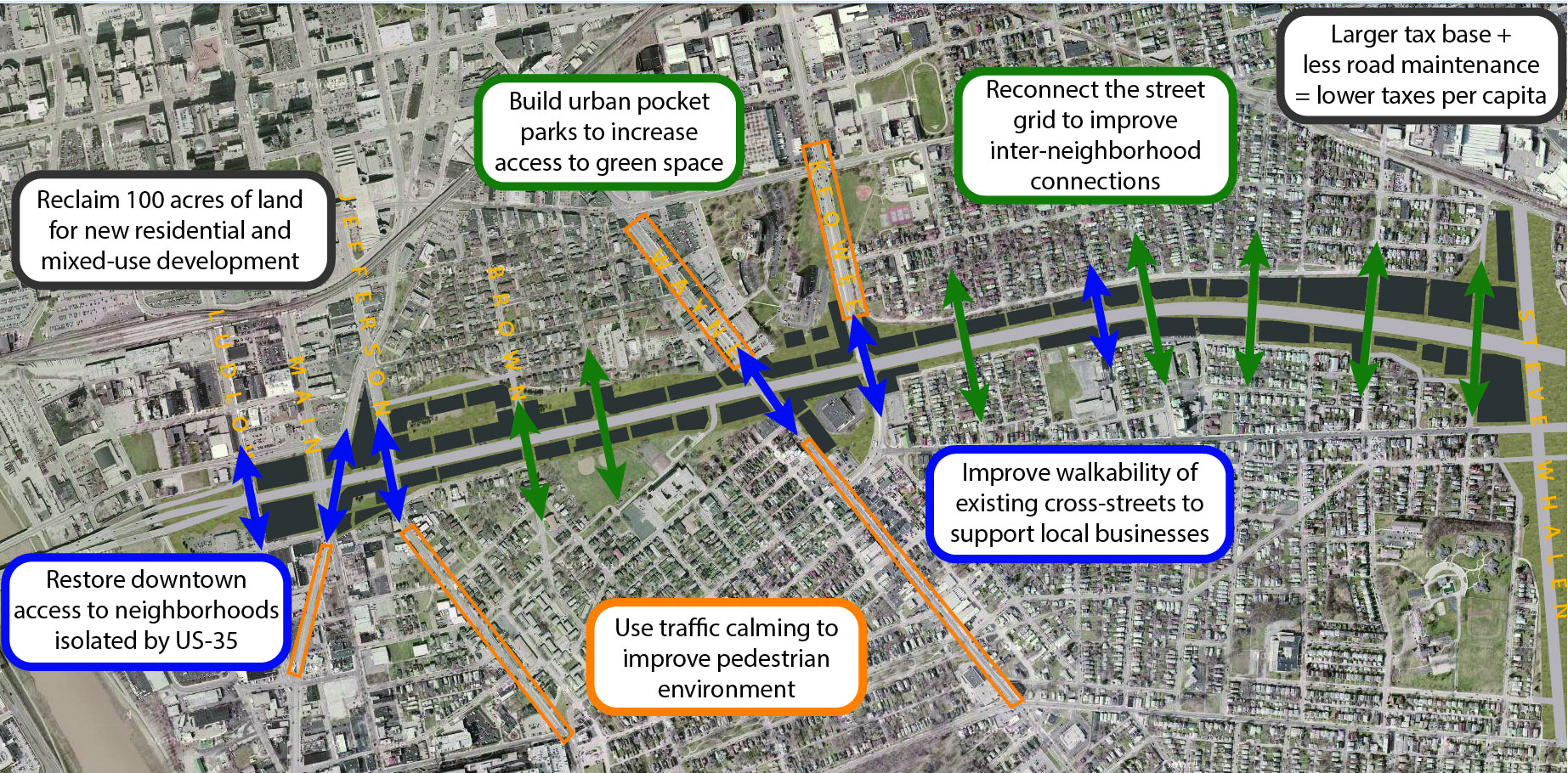
Both the local campaign and the city recognize that the additional land available for housing development will create key opportunities to implement effective anti-displacement strategies. Planning for this new development will require collaboration with anti-displacement experts and extensive community outreach. Two primary strategies are likely to be used: inclusionary zoning, which will require a portion of new development to include affordable housing, and the establishment of a community land trust to support affordable homeownership and prevent speculative investments.
The removal of US-35 will create additional land for development that can help alleviate the current housing shortage in high-demand neighborhoods and reduce housing costs by increasing the supply of affordable homes. Removing the highway will also enhance walkability, boost foot traffic that supports existing local businesses and create opportunities for new businesses to open.
These changes will foster a vibrant and diverse community with a thriving local economy. The buy-in from city officials demonstrates that highway removal is a feasible and beneficial tactic to addressing the multitude of quality-of-life issues such as air pollution, housing affordability, and limited connectivity impacting communities across America today.
Interstate 5 in Seattle opened in 1967 and caused the largest population displacement in the city’s history. Today I-5 is vital but causes air and noise pollution that impacts the health and well-being of thousands of people living and working near it, and it takes up valuable land in an area with an extreme deficit of open space and other civic assets. Highway capping with the Freeway Park (1976) and the Seattle Convention Center (1988) span over I-5 and have begun to restitch the central neighborhoods, but much more work remains.
The local campaign, Lid I-5 is seeking a win-win solution that addresses a need for new public land, capping the pollution, and retaining the critical transportation function. They have worked with the public on new design concepts that could add another 17 acres of lid area over I-5. The group recognizes that an expanded I-5 lid can simultaneously address several of the pressing challenges Seattle faces.
In 2023, Lid I-5 secured $500,000 in state funding for direct or indirect support of the project and in 2024 they secured (with City as sponsor) a $2 million Reconnecting Communities grant. The Lid I-5 team has been the lead on community outreach since launching in 2015. They have led workshops/charrettes, open houses, walking and biking tours, media interviews, webinars, hosted guest speakers from other freeway lid projects, and much more. Lid I-5 started doing scientific polling to find out how effective their work has been, and it turns out that more than 60% of Seattle voters support the project.
Today, the half-mile section of I-794 through Downtown Milwaukee poses an unnecessary barrier between two of the city’s flagship neighborhoods and consumes 32.5 acres of the most valuable and unused commercial and residential real estate in Wisconsin, estimated to be worth as much as $1.5 billion. Several structures on this east-west section of I-794 have reached the end of their useful life, presenting a once-in-a-generation opportunity to reconnect Milwaukee’s traditional commercial center to the Historic Third Ward.
WisDOT’s own data shows that this portion of I-794 is underutilized as the majority of I-794’s drivers are traveling to and from downtown and the Third Ward rather than using this section of I-794 just to pass through Downtown. Rethink 794’s goal is to have the City of Milwaukee and WisDOT remove this elevated portion of I-794 and reconnect it to the heart of the city with new development and pedestrian facilities.
Since the 2023 report, Rethink 794’s idea has been endorsed by the Mayor of Milwaukee. The group released additional renderings, including an augmented reality experience, and WisDOT has included a boulevard option amongst their seven alternatives, which Rethink 794 has endorsed. The group also released a study showing removal would generate billions in disposable income, hundreds of millions in taxes and generate more than 3,000 housing units.
They are awaiting the next round of public meetings, expected later this year. There should be three final alternatives at these meetings, with WisDOT eventually selecting a final alternative.
Twenty-two local streets became dead ends when WSDOT built SR 99 across the South Park street grid. Neighbors lost direct, walkable routes that connected them to each other, neighborhood destinations, and gathering places. SR 99 was built to cut through rather than serve the South Park community. Starting in the mid-20th century, South Park began to bear many of the environmental burdens associated with Seattle’s booming industrial economy: industrial pollution, air and noise from highways and overhead flight paths, Duwamish River contamination, among others.
In 2023 and 2024, Reconnect South Park (RSP) focused on community engagement and outreach, connecting with residents, business owners, and community leaders from South Park and adjoining neighborhoods to work toward building a Community Vision Plan for SR-99 through South Park.
In 2023, RSP discussed the project with more than 650 community members, organized or presented about the project at more than 30 events, and collected 70 survey responses that will guide the project going forward. Outreach continued in 2024 with coffee chat events, open houses, and information booths at summer events. In 2024, the City of Seattle engaged technical consultants Kimley-Horn to examine the anticipated mobility, safety, health, environmental, and economic impacts of these alternatives and develop a final report in mid-2026.