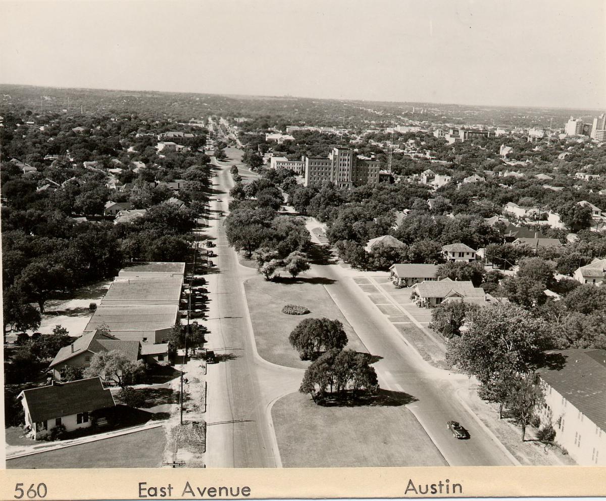
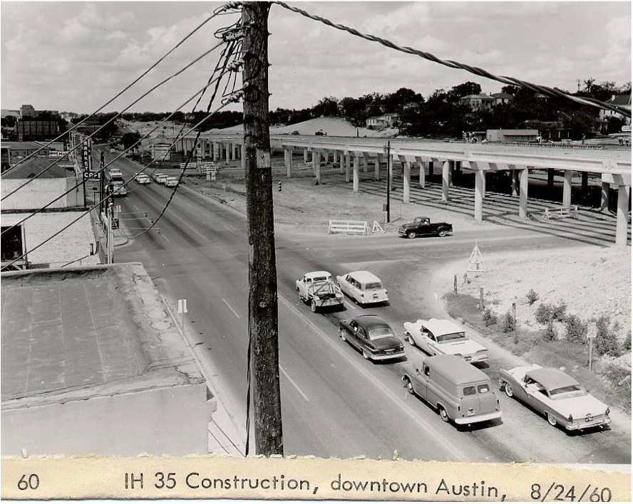
Before the highway boom of the 1950s and 60s, a quiet tree-lined boulevard named East Avenue marked the eastern boundary of a connected downtown grid, and existed in the footprint of what is now Interstate 35 (I-35). Following federal policy, the Texas Department of Transportation (TxDOT) began purchasing right-of-way for I-35 as early as 1948, and by 1962 had opened the elevated downtown portion of the highway. Its footprint followed long-established racial and economic divides set forth by the city’s 1928 Master Plan and 1931 Zoning Map, and became a physical barrier that reinforced those divisions for decades.
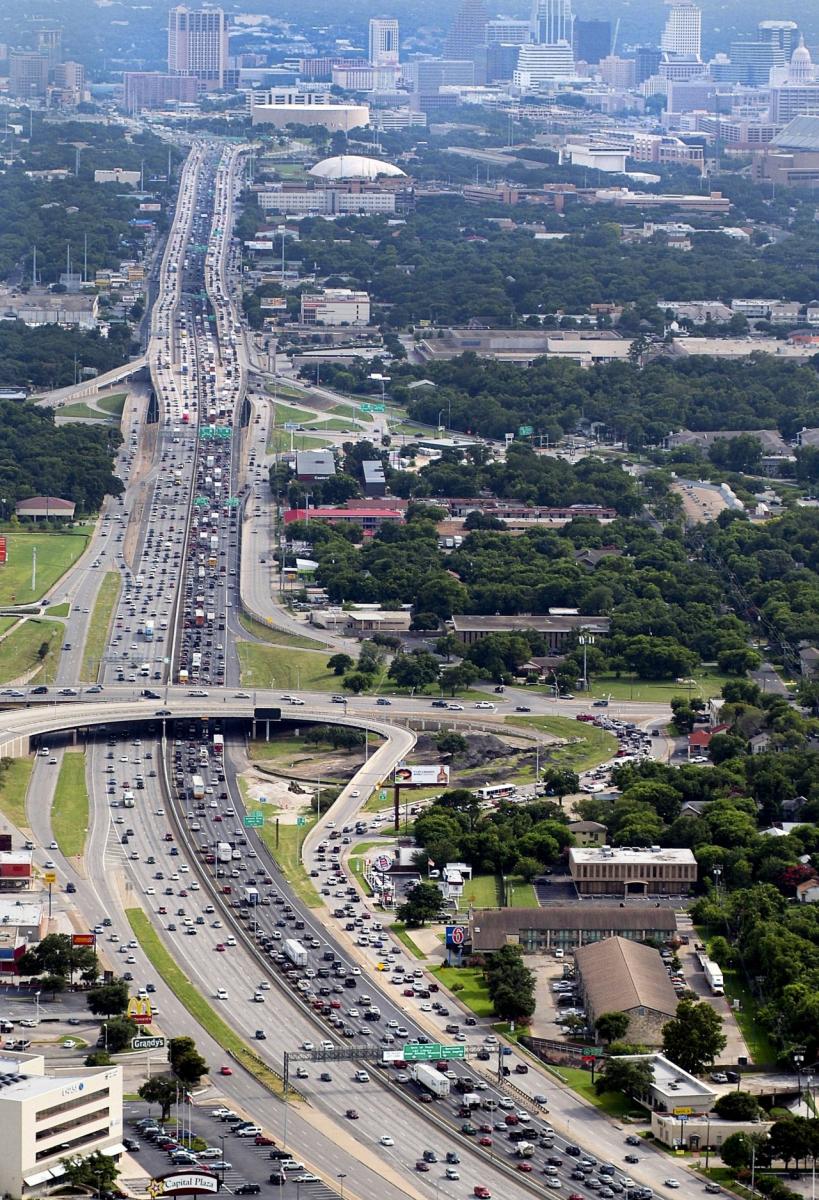
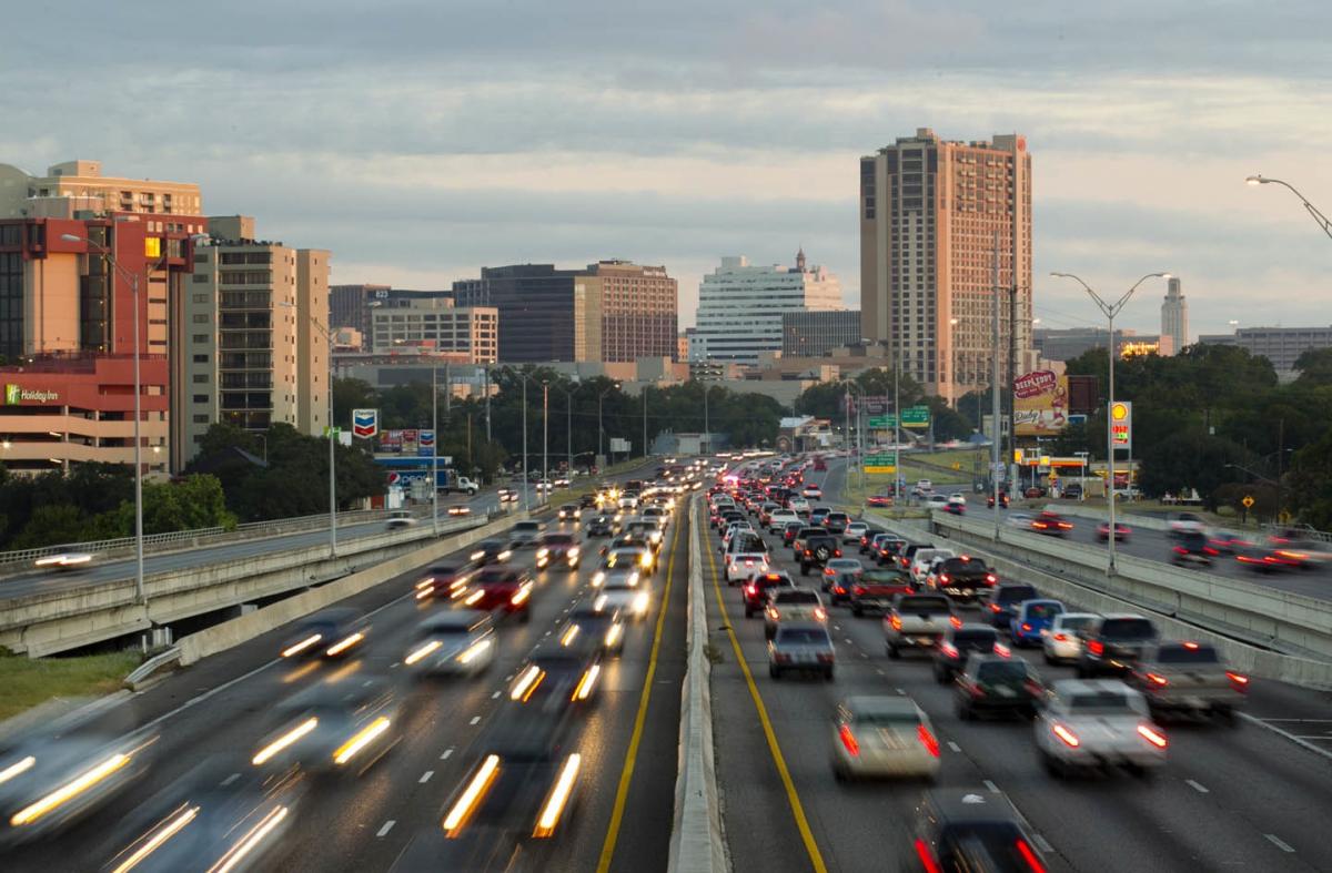
Today, I-35 is designated a NAFTA trade route, and the downtown corridor carries more than 200,000 vehicles each day. In 2013, it was ranked the most congested roadway in Texas, and has consistently been ranked among the top 10 congested roadways nationwide over the past five years.
As early as 1989, TxDOT was conducting major investment studies on redesigning the highway, thanks to local input. These efforts, however, yielded little change. State legislative action in 2011 allocated significant funding for feasibility studies and project planning targeted at the most congested roadways in Texas, including I-35. This, coupled with the elevated structure nearing the end of its life, turned significant focus back on the roadway and its future design.
For over two years TxDOT and the city of Austin have been working with stakeholders to identify and evaluate strategies. Among the first strategies recommended in TxDOT’s mobility plan was a “super streets” design that would have eliminated left-turn movements from cross streets, and eliminated most east/west traffic flow across the barrier created by I-35. TxDOT also put forth a “modified existing” design plan that mainly reconstructed the current elevated structure, ignoring lessons learned after living with the original elevated design for over 60 years. Both options raised deep public concern over the prospect of significant investment in either maintaining the ill-functioning status quo or a creating greater disruption of connectivity.
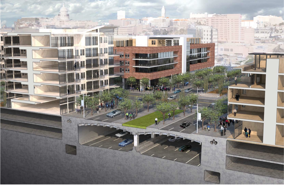
Concerted efforts by the city of Austin and local organizations like Reconnect Austin have helped to significantly shift the dialogue about design options. Reconnect Austin, founded by Sinclair Black, has long-since advocated for a vision of the I-35 downtown corridor that creates human-scale streets that help to reconnect the urban grid. Their “cut-and-cap” approach calls for depressing the main lanes of the highway and constructing a complete cap over the depressed lanes, resulting in a boulevard, much like the original East Avenue. Reconstructing the grid would distribute traffic evenly and increase the number of connections into downtown. The design adds tree-lined Great Streets creating a safe, civilized, walkable/bikeable urban space that becomes an integral part of the fabric of Austin.
The Reconnect Austin design vision also proposes reducing the current right-of-way which, in turn, unlocks about 30 acres of under-utilized, high-value real estate for mixed-use projects. The 25-year build-out projection could support over 7,000 residents, create close to 48,000 jobs, yield $3.2 billion in new tax base, and generate an estimated $1 billion in recurring, new property tax revenue. Depressed lanes also offer reductions in air and noise pollution.
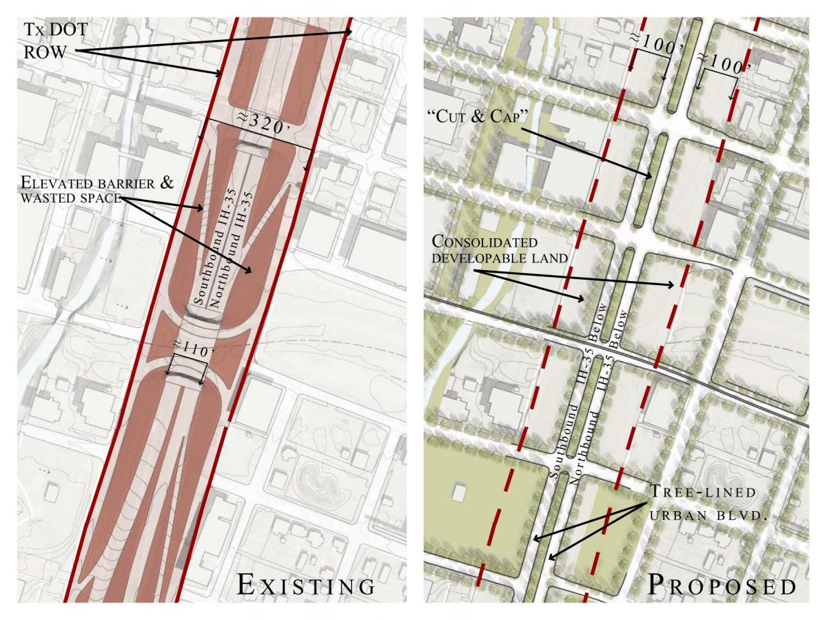
Through a recently completed year-long stakeholder input process, TxDOT has revised their design options to include a depressed highway with modified frontage roads and bridges across at existing connections. This option includes plans to structure the walls of the depressed main lanes so they can support future caps along the corridor. Though public concern remains over the current design’s east/west connectivity across the highway, the agency is now readying itself to move the depressed lanes design into the National Environmental Policy Act (NEPA) review process. NEPA review is currently slated to include both the “modified existing” and the “depressed” alternatives, despite a clear and documented preference for the “depressed” option from many community groups, neighborhood organizations, the Austin City Council, and the Downtown I-35 Stakeholder Working Group. Austin’s I-35 debate is shaped by a unique set of constraints and conditions. Unlike the Central Freeway or Harbor Drive, I-35’s downtown corridor carries high volumes of traffic daily, and is a key trade route that stretches from Canada to Mexico. Due to these conditions, it has been argued that it is not feasible to remove the highway completely.
Austin is also one of the fastest-growing cities in the US, and with a saturated housing market and lacking transit infrastructure it becomes increasingly vital that any major transportation investments align closely with sustainable land use planning and development. Austin’s urban core is changing rapidly. Currently there are over 80,000 students, faculty, and staff at the University of Texas, Austin, over 23,000 jobs at the State Capitol Complex, plus 10,000 residents and 50,000 jobs downtown. Add to that high density student housing next to the University, 3,000 additional dwelling units under construction downtown, 3,000 hotel room and 1.45 million square feet of office and retail also currently under construction downtown, as well as new Medical and Innovation Districts, and you have significant changes in land use and transportation patterns that should be considered in the design of I-35. A 1950’s highway solution is not appropriate or welcome.
The cut and cap proposal would allow vital reconnections of the downtown grid, improving connectivity for local drivers, pedestrians, and future transit development. Reconnect Austin and other community-led efforts continue to push the dialogue with TxDOT and the city of Austin to ensure that the final redesign of I-35 supports safe and efficient travel for all modes, and serves as a model of forward-thinking, sustainable transportation planning and urban design.

To stay up to date on the progress in Austin, make sure to regularly check the Reconnect Austin website.
Watch this Reconnect Austin video.
Top photos: Austin, 1953 and 2013. Source: The Institute for Quality Communities - University of Oklahoma
Similar Projects

Gardiner Expressway
Toronto, Canada
Built between 1955 and 1966 by the Ministry of Transportation of Toronto (MTO), Toronto's Frederick G. Gardiner Expressway is a major east-west thoroughfare that connects downtown Toronto to its western suburbs.
I-490 Inner Loop
Rochester, New York
In the early 1950s, when construction began on Rochester's Inner Loop Highway, the city's population was about 330,000.
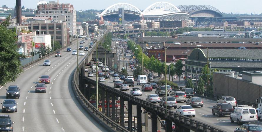
Alaskan Way Viaduct
Seattle, Washington
Alaskan Way started as a rail yard to accommodate the City's industrial needs along the waterfront of Elliot Bay in the 1880s.