


History and Context
The IL 137/Amstutz Expressway was built in the 1970s-1990s to connect the industries of Waukegan and North Chicago’s lakefronts to I-94 and north to Wisconsin without burdening their downtowns with heavy industrial traffic. Though IDOT built the portions in Waukegan and North Chicago, the planned extensions were never built, and the lakefront industries the expressway was built to serve have since left. What remains is an overbuilt road to nowhere that diverts traffic and visitors away from the cities’ downtowns and separates the communities from their lakefronts. In addition to restricting access to the lake, the lack of connectivity has also been a barrier to the transformation of the lakefront areas into the mixed-use, transit-oriented developments envisioned by the cities’ master plans.
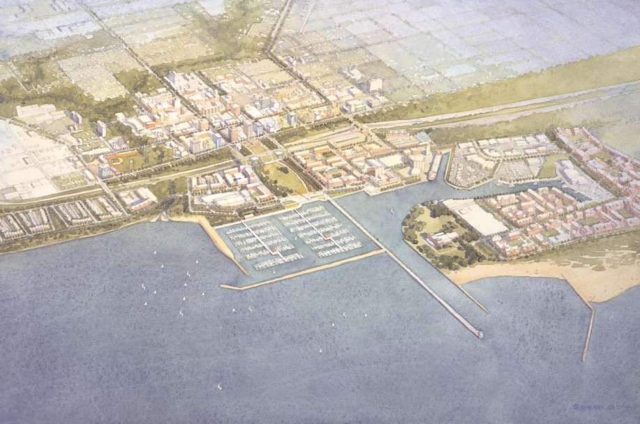
Proposal
Initiated by the Cities of Waukegan and North Chicago, the IL 137/Sheridan Road Corridor Project has received partial funding for the feasibility study through an Illinois Statewide Planning and Research Funds (SPR) grant. This study builds on the 2003 Lakefront Downtown Master plan that provides three alternative designs for a reimagined Amstutz Expressway. The vision for the project includes a removal of the southern portion of the Amstutz, a capped park extending over the portion of the corridor in downtown Waukegan, and a boulevard to replace the northernmost portion. More connections and grid alignment throughout will be considered. The ultimate design will weigh the recommendations of the studies with the visions presented by the community.
The community needs a transportation system that serves their transportation needs. The combination of removal and “boulevarding” the Amstutz will provide a right-sized road for the relatively low Annual Average Daily Traffic (AADT) count of approximately 5,750 that currently occurs on the corridor, a number that has decreased over the years (source: IDOT 2023 AADT map). A road with this design and designation would typically carry up to four times as much traffic. In addition to the benefits of improved connectivity and access to resources, a smaller road will be less costly to maintain and provide an aesthetic improvement for commuters and neighbors.
Current Plans
The capped park will extend over a block-size portion of the corridor from downtown Waukegan to the waterfront, adding needed green space to the downtown while providing a seamless pedestrian connection from the bustling economic engine of the city to its most precious resource. The areas created by the removed highway will follow community-inspired design guidelines from the cities’ master plans and will be designed to integrate into the community.
In addition to recognizing the displacement caused by the construction of the Amstutz, the City of Waukegan is conscious of the threat of displacement posed by highway removal. In a similar manner, they are aware of the blight caused in part by the highway’s construction and will focus all future developments on the corridor to reverse that damage and raise property values sustainably. Quality of life will increase but not at a level that displaces current residents. Development in newly opened land will be on City-owned parcels where the city has control over development, so proposals will need to integrate into the existing environment and must win the support of the community to be approved. These developments will fill the “missing middle” that exists in Waukegan’s current housing stock. The inclusion of anti-displacement matters has been emphasized in grant applications and its consideration will be required in all stages of development.