


History and Context
Planned and built in the 1960s, US-35 tore through numerous local communities and reinforced segregation within the corridor. As a result, these once thriving communities were severely harmed as hundreds of homes and businesses were destroyed to construct the highway.
The residents and businesses who remained were isolated from each other and struggled to maintain the pre-existing community. Further westward expansion of US-35 occurred in the 1990s which destroyed more local homes and businesses. To this day, the highway continues to negatively contribute to the health and quality of life of residents and prevents residents from accessing community resources. Neighborhoods in the vicinity of US-35 have slowly begun to rebound and rekindle the economic activity of a century ago but development is impeded by the negative impacts of US-35.
Proposal
The local campaign, Dayton Freeway Removal, is actively building support for removal, and city officials have applied for federal Reconnecting Communities funding to research alternative designs. Removing the highway would reconnect neighborhoods with community amenities while eliminating the harmful impacts of a highway cutting through a neighborhood.
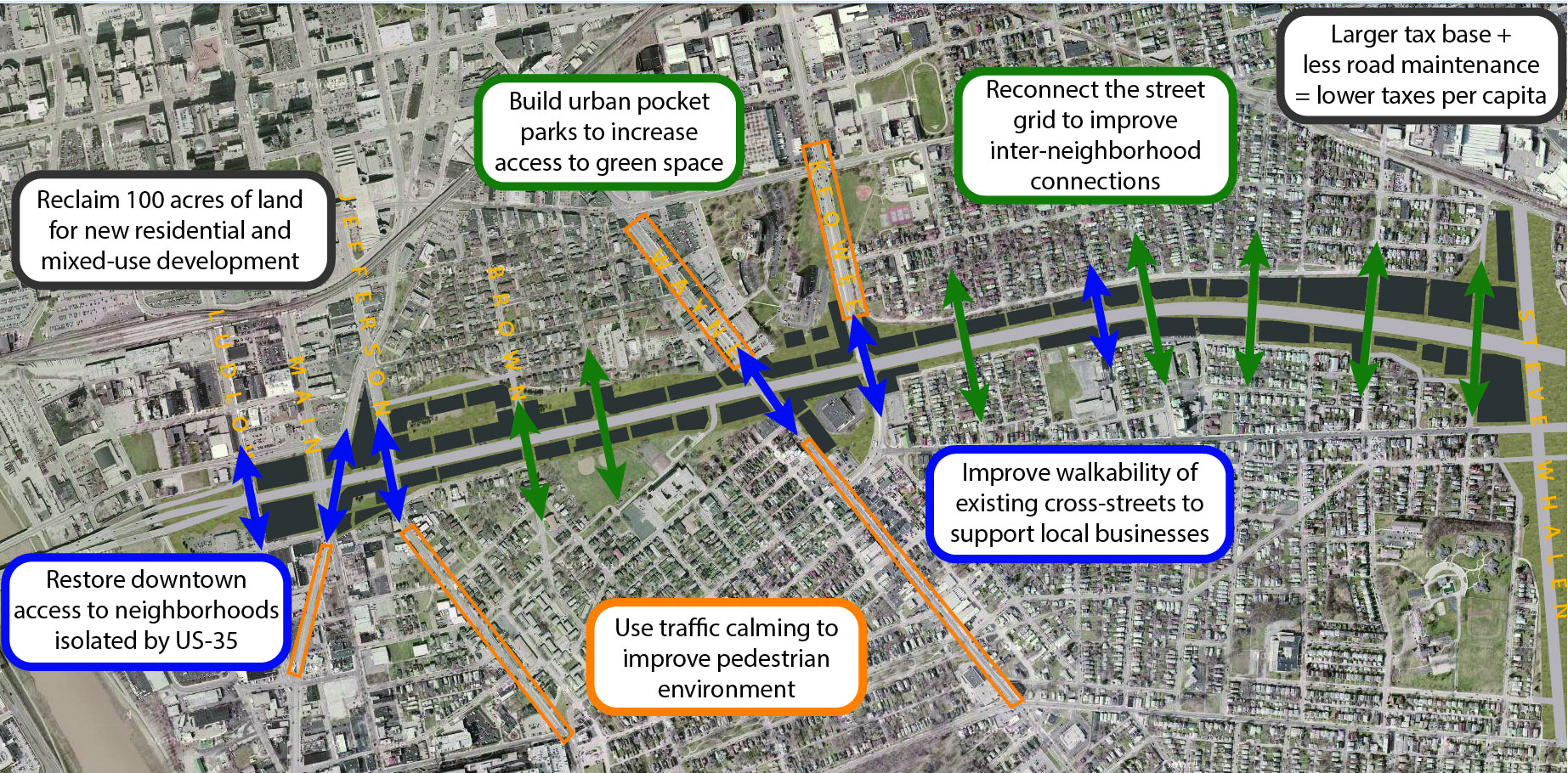
The alternative design proposes a conversion of the 240-foot-wide highway corridor into a 4-lane boulevard with shared-use paths on both sides, reducing the roadway footprint to approximately 100 feet. The remaining land, including land presently occupied by interchanges, will be repurposed for housing, parks, and other developments. Along local streets with storefronts, intersections will be designed to support mixed-use development and unite currently disconnected commercial districts. In residential neighborhoods, the boulevard will reconnect streets previously divided by US-35 and provide a diverse set of housing options to meet the varied needs of the community.
In areas facing high housing demand and rising costs, the removal would create opportunities to build both affordable and market-rate housing to ease the housing crisis. New green spaces and parks can also be created along the corridor to ensure that all community members have safe and convenient access to neighborhood parks. This is demonstrated by the current situation where seven schools, two large parks, and a library lie along the 5-mile stretch, but residents on the opposite side of the highway struggle to reach them as they have to utilize a noisy pedestrian overpass or cross at a dangerous highway on/off-ramps.
Current Plans
Both the local campaign and the city recognize that the additional land available for housing development will create key opportunities to implement effective anti-displacement strategies. Planning for this new development will require collaboration with anti-displacement experts and extensive community outreach. Two primary strategies are likely to be used: inclusionary zoning, which will require a portion of new development to include affordable housing, and the establishment of a community land trust to support affordable homeownership and prevent speculative investments.
The removal of US-35 will create additional land for development that can help alleviate the current housing shortage in high-demand neighborhoods and reduce housing costs by increasing the supply of affordable homes. Removing the highway will also enhance walkability, boost foot traffic that supports existing local businesses and create opportunities for new businesses to open.