Cities across America have been damaged and disfigured by urban freeways—and the recently completed Albany Skyway shows how they can begin to heal.
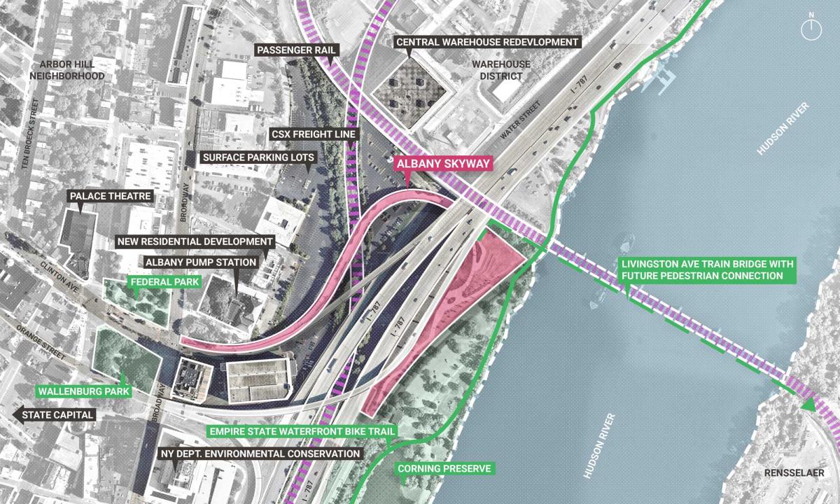
The $15 million Skyway—converting an Interstate ramp into a half-mile bike-ped corridor and park—realizes part of a long-held community vision to take back the waterfront as an accessible urban amenity. Connections between the City and the Hudson River have long been impeded by the I-787 elevated highway built in the 1960s. The highway severed neighborhoods, and along with concurrent “urban renewal” related to a state office complex that the highway serves, displaced an astonishing 7,000 people. One long-term goal is to demolish the freeway, but that process could take many long years.
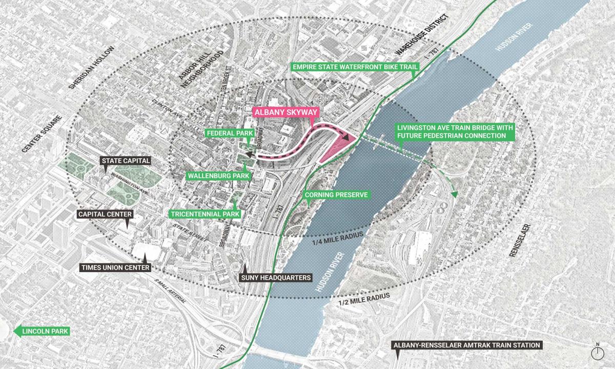
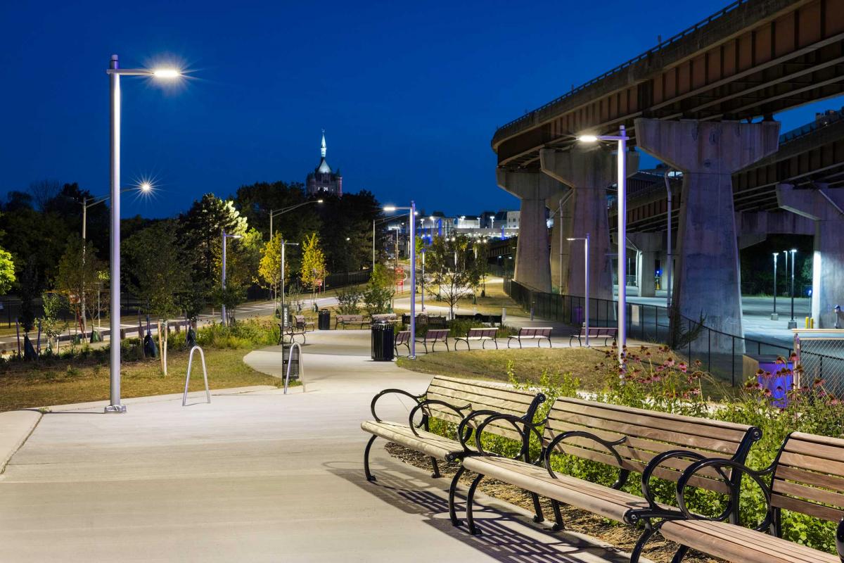
In the meantime, the City now has secure and direct access to the Hudson River, including the Corning Riverfront Park and a regional trail system that extends 750 miles in three directions. Prior to the Skyway, reaching the waterfront from downtown required passage through public parking areas, a tangle of highway lanes, multiple signalized intersections, and unmarked and unlit walkways. The Skyway itself is a fantastic amenity—both a journey and a destination—that supports active lifestyles and restores historic connections between downtown and underserved neighborhoods.
"The completion of the Albany Skyway is a game-changer for the City and the perfect example of a transformative infrastructure project that promotes equity and connectivity,” agrees New York Governor Kathy Hochul. “Infrastructure can be more than just building roads and bridges—like the Skyway, it can be about improving quality of life and righting the wrongs of the past.”
The Skyway is a continuous, uninterrupted, and safe link to the waterfront— and for all the travelers passing through on the Empire State Trail, it invites quick and intuitive access into downtown Albany.
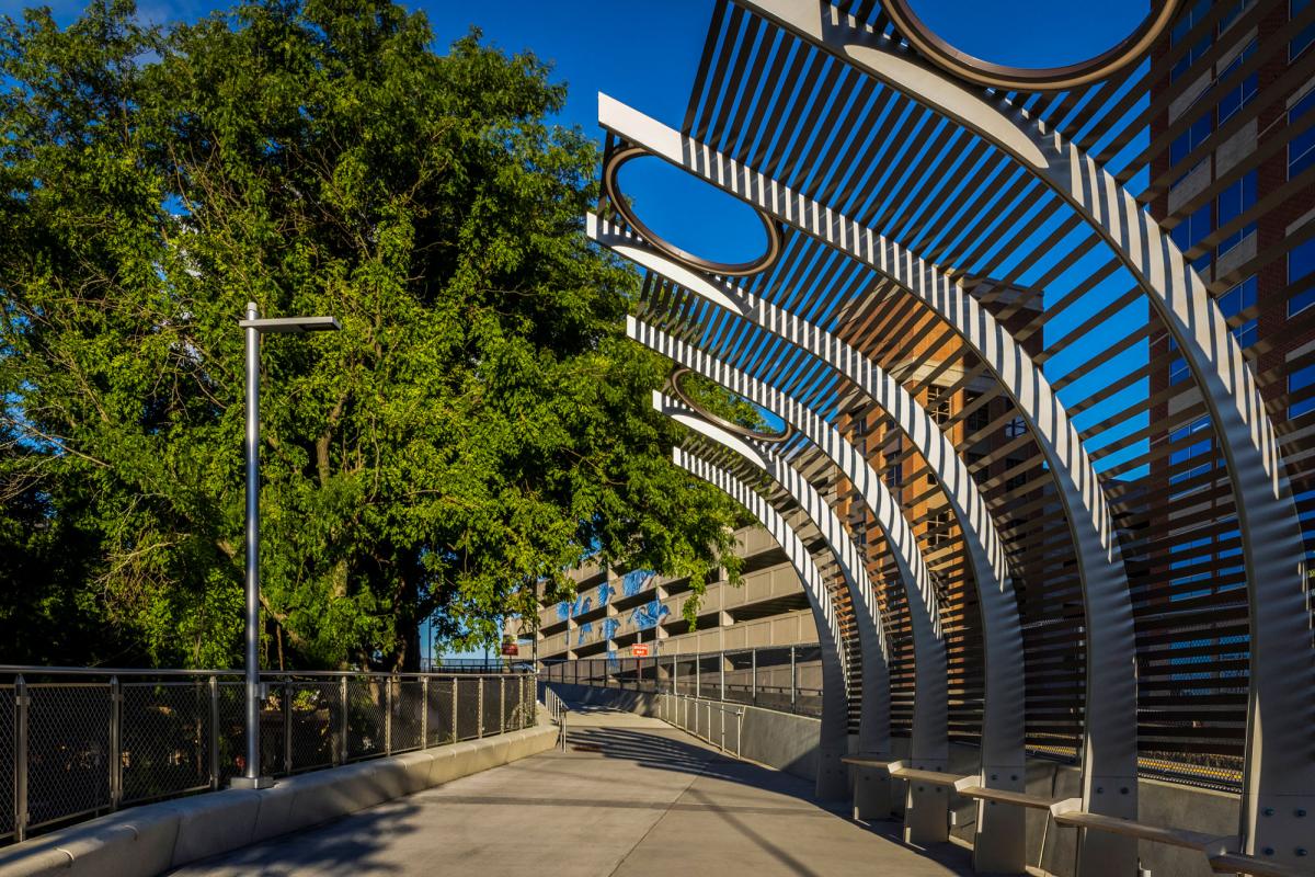
The new park totals 3.3 acres and 2,680 feet in length from the intersection of Clinton Avenue and Broadway in downtown to US Route 9 by the river. Along the way are a 3,000 square foot outdoor art gallery, seating capacity for 600 people, 90,000 square feet of softscape park space with over 20,000 native plants and trees, and a 5,000-square-foot shaded area. Eight outdoor pop-up event spaces (totaling 50,000 square feet) satisfy the community's desire for flexible spaces that change over time.
Open areas on the Skyway provide opportunities for informal performances and activities.
Environmental gains include light-colored materials and landscaping that reduce heating in the summer and reflect solar radiation. More than 50,000 square feet of impervious surface area was also removed.
“The Skyway not only provides a connection to the water, but also serves as a much-needed passive recreation and event space and an economic driver for downtown investment,” notes the design team, which provided quantitative research to evaluate the project's financial viability and to ensure that the City would see a return on investment for residents, workers, and businesses.
Because Albany is a mid-sized city with limited resources, the team had to work with a modest budget—considering the original condition of the infrastructure and the task at hand. “Working to this budget was among the achievements of the project,” notes the team.
How it happened
The Skyway emerged from a 2014 downtown revitalization plan, which envisioned a lively city center connected to the waterfront and its regional trail system, and to an adjacent warehouse district. “The design team recognized an opportunity in a section of elevated highway infrastructure that touched down within the city center and stretched uninterrupted over parking areas and under highway lanes to the riverfront,” the team explains. The Charter Awards jury was impressed with the difficulty of getting such a project built, involving a piece of federal highway, changes to which require coordination at all levels of government.
Initially, the idea seemed far-fetched, but it gained early endorsements from Albany Mayor Kathy Sheehan and the NYSDOT Commissioner. Governor Hochul, who came into office in 2021, also supported the idea, as did her predecessor, Andrew Cuomo. The ramp had been lightly used—only two thousand vehicles per day needed to be rerouted. This negligible impact on travel time made a good trade for a new destination park in the heart of downtown and vital pedestrian connections to City resources.
Physical and technical challenges
The existing ramp's loading constraints posed difficulties. The primary design elements—surfacing, planting beds, seat walls, and lighting—were coordinated with structural limitations, the design team explains. Another major technical issue was the slope and tilt of the highway deck, which was flattened to create a universally accessible corridor.
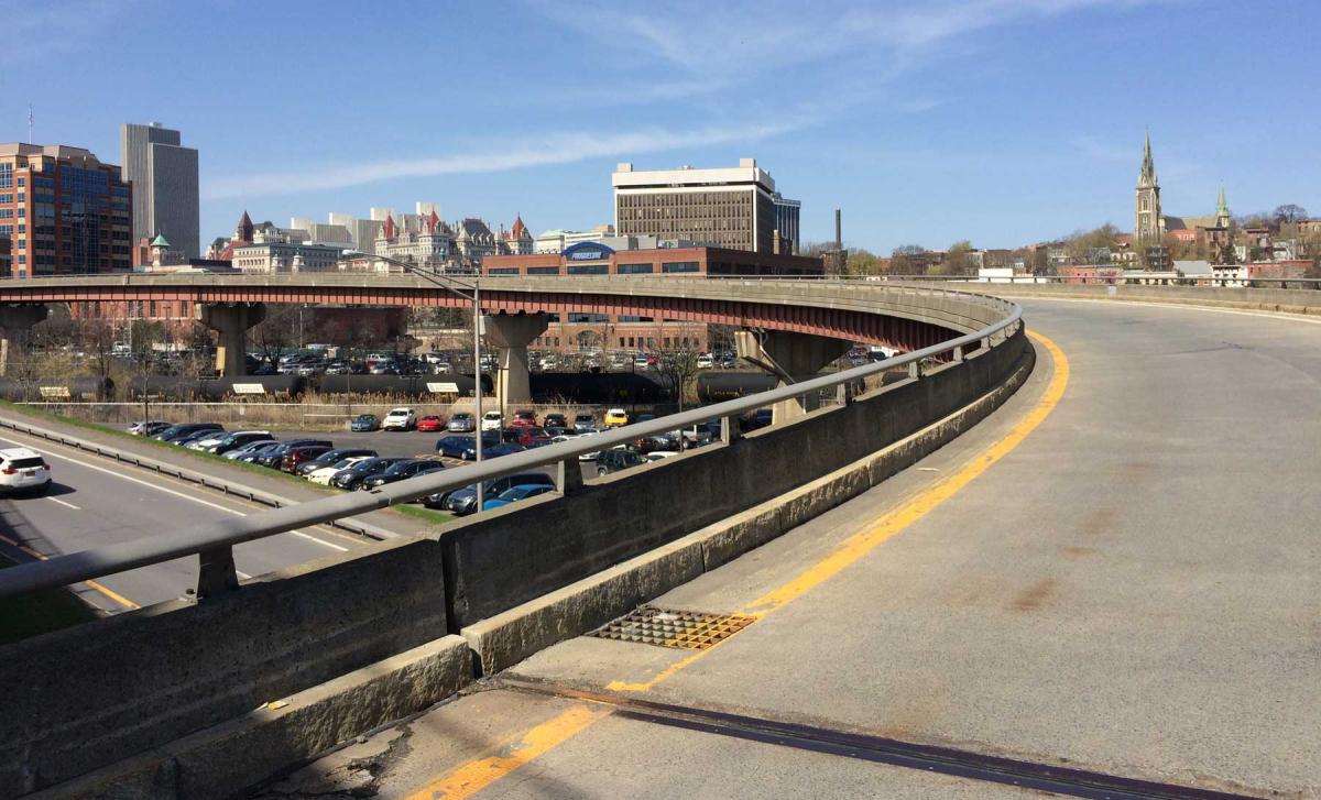
The elevated, 26-foot-wide piece of concrete, steel, and asphalt would not seem like much to work with—it was described as an “ugly chunk of highway” snaking under an Interstate and over rail lines, surrounded by the noisy spaghetti of travel lanes and elevated ramps. It took real vision to see it as a park. The Skyway maximizes its limited resources by reclaiming an underutilized asset in a way that is aligned with Albany's vision for the future: an equitable and connected pedestrian and bicycle-friendly community.
Today, the Albany Skyway remains a thoroughfare, but it’s now one that welcomes people on foot, on bike, or in wheelchairs. The jury observes, “The designers have transformed a forgettable off ramp into a place worth visiting, and reconnected a city to its waterfront.”
View Albany Skyway's Charter Awards ceremony video here.
Similar Projects
WeCollab
St. Louis, Missouri
It is now standard practice to conduct extensive public outreach in neighborhood planning. WeCollab in the St.
Hammond Downtown Master Plan
Hammond, Indiana
Based on the past sixty years, one would expect Hammond, Indiana, to continue shrinking and its downtown to stagnate indefinitely.
Downtown Westminster
Westminster, Colorado
A large number of malls are dying nationwide—but in most cases, a city or town just lets a developer or investor determine the fate of a property, if there is a market for reusing the site.