History
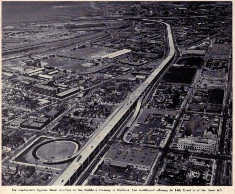
The Cypress Street Viaduct in Oakland was opened on June 11, 1957 as the first double-decker freeway in California. The viaduct was part of Interstate 880, linking I-280 in San Jose to I-80 in Oakland. It was intended to connect drivers to the Bay Bridge as well as reducing local road traffic. However, the highway was built directly through the middle of the West Oakland neighborhood, cutting it in half, and along with the construction of Interstate 980 to the south, isolating it from downtown. The pair of highways essentially encircled West Oakland, presenting a formidable barrier to cross on foot out of this redlined neighborhood, home to a large Latino and African American population. In total, the construction of the Cypress Street Viaduct displaced over 600 families and the surrounding urban renewal projects destroyed over 5000 residences.
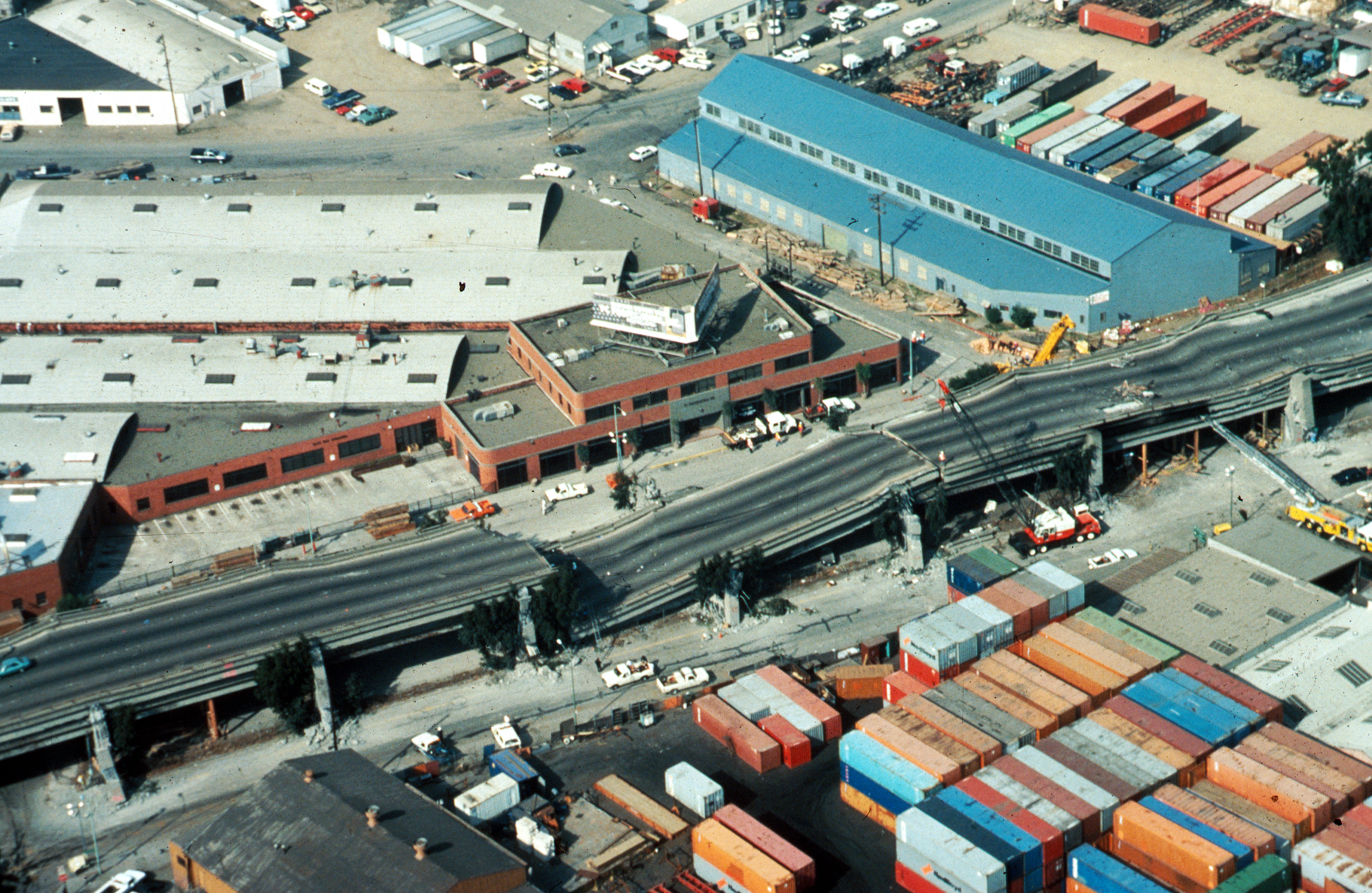
In 1989 the 7.1 magnitude Loma Prieta Earthquake struck the San Francisco Bay Area, killing over 100 people and injuring over 3,000. In addition, it caused $100s of millions in damage throughout the area. Local infrastructure was severely compromised, including the collapse of a section of the Bay Bridge, damage to the Embarcadero and Central Freeways in San Francisco, and the total collapse of the Cypress Street Viaduct between 7th and 18th Streets. This spurred a larger conversation around the investment in freeways in the Bay Area and whether or not their costs outweighed the benefits. San Francisco ultimately chose to remove the Embarcadero and Central Freeways, while Oakland explored other options for the Cypress Street Viaduct.
Plan
After the quake, the highway was completely destroyed, and without suitable alternative routes the over 160,000 daily vehicles were forced onto the other highways and local streets causing heavy congestion. However, with this tragedy came an opportunity for Oakland to revitalize a neighborhood and reconnect it with the rest of the city. The community involvement process was one of the key tenets of the reconstruction of the highway. As part of the environmental review process, Caltrans selected a new route that re-aligned the freeway along an industrial area and railroad yard. The $1.1 billion project rebuilt the highway in a more appropriate area, outside of residential and commercial areas. Along the highway’s previous route, Oakland built the Mandela Parkway, a four-lane boulevard with a wide, green median that reconnected the formerly bisected West Oakland community.
Project
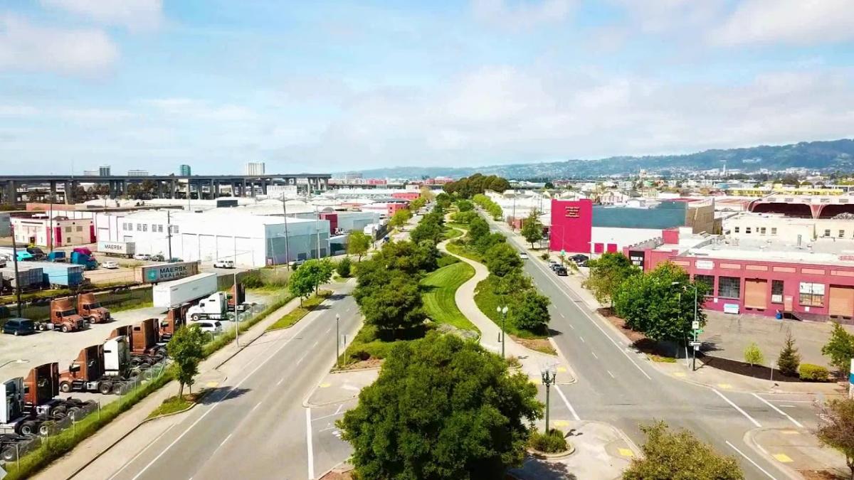
The $13 million, 1.3-mile Mandela Parkway was the catalyst in this reconstruction effort, uniting for pedestrians the two sides of West Oakland. The parkway boasts many amenities that support walkable, healthy communities including: 68 species of trees, two bike lanes, walking paths, grass lawns, and acorn shaped light fixtures, touching on the local nature of the city. Along with the urban design improvements, approximately three dozen new business have sprung up around the parkway, spurring economic development along its path. Between 1990 and 2010, the percentage of West Oakland residents in poverty decreased 14% and the median household income increased by $5,720. Opened in 2005, the Mandela Gateway affordable housing project provides 168 affordable income housing for residents of the West Oakland neighborhood. The removal of the highway from the middle of the neighborhood has had several health benefits. Annual nitrogen oxide levels around the parkway decreased by 38% and annual black carbon levels decreased by 25%. Furthermore, the parkway forms a critical link in the Bay Trail, a 500-mile walking and bicycle trail planned around the San Francisco Bay. Mandela Parkway has become a new community focal point, promoting connected and active urban life.