Students at the University of Maryland were tasked with reimagining the west bank of the Schuylkill River in Philadelphia as a vibrant, mixed-use neighborhood, repairing the urban fabric in the process. Amtrak’s main corridor through Philadelphia runs north-south just across the river from the area, and Historic 30th Street Station is a transit hub for Amtrak, local commuter rail, local and regional bus service, and city subway rail. Interstate 76, running along the western bank of the river, is a heavily travelled artery that passes below the ground plane of 30th Street Station. The combination of the highway, rail lines, and extensive rail yards north of the station completely cut off access to the riverfront and hinders the pedestrian experience. With the nearby campuses of the University of Pennsylvania and Drexel University expanding, the underutilized railyard area is ripe for development.
Will Bruder felt that this proposal “…was the most professionally presented ‘un-built’ work in the competition. Big ideas, a beautiful sense of livability and invention at both the large scale and the fine grain distinguished it from other entries. The students created a very rich combination of architectural form and massing and a landscape of softened pedestrian possibility for the refinement of this concept. Their plan, in its organization and depth of visual richness, is a standout example of contemporary thinking. Beautiful renderings and plans make it easy to engage the concepts.”
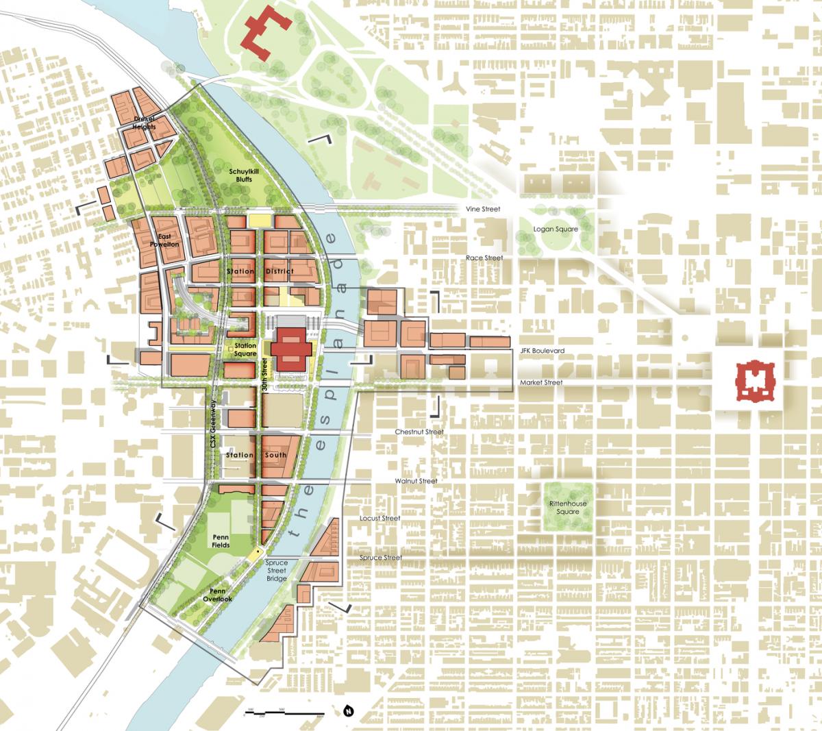
The design interventions respond to the following three goals: leaving the current infrastructure intact, weaving the city grid together from east to west, and creating a pedestrian green circuit and park system. To leave the current infrastructure intact, the reconstituted ground plane of the station is extended to cover the existing rail yards. This new real estate allows for building and block development as well as for a new park over the rail yards. To knit this development into the context, the existing street grid of the neighborhoods to the west is extended to meet the grid from Center City.
To anchor the development, the design emphasizes 30th Street by extending it to the north, with imageable public spaces. A pedestrian esplanade along the river bank works as a second north-south connector-- a greenway that links Penn Fields with the proposed residential neighborhood to the north.
“This plan is long overdue and wonderful,” exclaimed Adele Chatfield-Taylor. “Building over the rail yards and providing mixed-used properly-scaled development to engulf and support this important transit hub will set the stage for new neighborhoods and provide pedestrian access to all aspects of this district.”
Similar Projects
Jean Lafitte Tomorrow
Jean Lafitte, Louisiana
Of all the projects recognized by the 2013 Charter Awards jury, this project inspired particular warmth – particular enough to create a special award of recognition for its locally driven, handcrafted approach.

Heart of Lake
Xiamen, China
Slated to have its eight phases of construction complete in 2018, Heart of Lake is a New Urbanist community being built from the ground-up in the temperate coastal city of Xiamen, China.
Southwest Waterfront
Washington, District Of Columbia
Part of Pierre L’Enfant’s original plan for the Capitol, Washington, DC’s Southwest Waterfront has seen better days. At the beginning of the 20th century, it had a thriving commercial corridor and a multi-ethnic community.