History
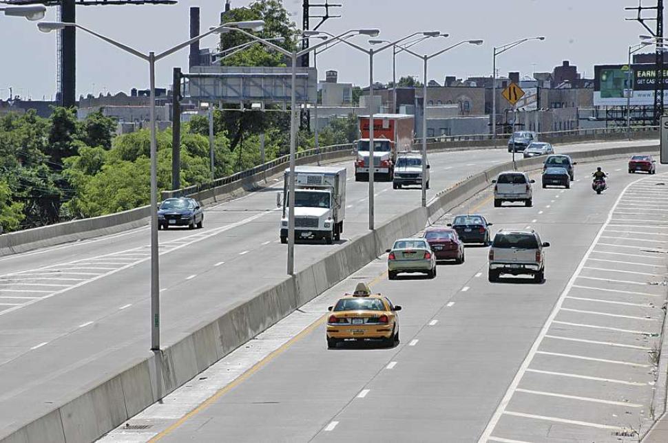
Built in 1963, the Arthur V. Sheridan Expressway, also known as I-895, was designed by Robert Moses to connect the Bruckner Expressway (I-278) with the New England Thruway (I-95) in the Bronx and connecting the commercial vehicles from the Hunt's Point Food Distribution Center to the larger interstate network.The Expressway cut through four diverse and complex community districts, two of which saw a two-thirds population decrease in the 1970's, which is the greatest loss the Bronx has seen. It also brought even more industry to the Hunt's point area, increasing the urban run-off and industrial pollution to the nearby Bronx river. The river was not only cut off from the local residents, but also made less desirable to be around in the process.
Influential stakeholders were able to curb the second phase of the expressway, a four-mile expansion slated to pass through the Bronx Zoo and New York Botanical Gardens. However the beginning phases of the project were already complete and left the Sheridan as an awkward, poorly-connected 1.25-mile spur that mars the waterfront along the Bronx River. The Sheridan currently carries 35,000 vehicles per day between Bruckner Expressway and Westchester Avenue. Less traffic travels on the Sheridan than many of the nearby major thoroughfares such as the Bruckner Expressway (117,000 vehicles per day), while the surrounding communities have still seen an increase in asthma levels.
Proposal
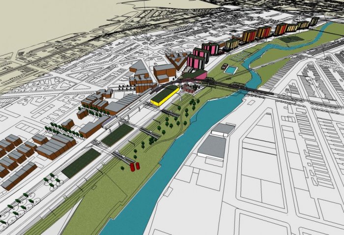
In 1997, The New York State Department of Transportation (NYSDOT) proposed a $245 million project to reconstruct and extend the expressway. Residents of the area voiced their opposition to this project, and a handful of community groups formed the Southern Bronx River Watershed Alliance (SBRWA) and created a Community Plan that NYSDOT agreed to study. Their vision replaces the freeway with a surface street, improves street grid connectivity, and reclaims 28 acres of land for commercial development, housing and open space along the waterfront. In addition, the SBRWA is calling to build ramps off the Bruckner Expressway so that trucks may access the Hunts Pointer Terminal Markets without driving through the community.
NYSDOT is analyzed two final scenarios for the future of Sheridan Expressway: one, retaining the Expressway and two, removing the Expressway entirely. After a study suggesting the removal of the expressway would worsen traffic, the plan to remove it was abandoned by the city. The SBRWA revealed that NYSDOT's traffic analysis had many flaws in its methodology and responded by calling in the transportation engineering and planning firm Smart Mobility, Inc. to provide an independent engineering review of the initial DOT findings. The firm's findings showed that the NYSDOT study did not consider the benefits of redeveloping 28 acres of land currently occupied by the Sheridan.
Current Plans
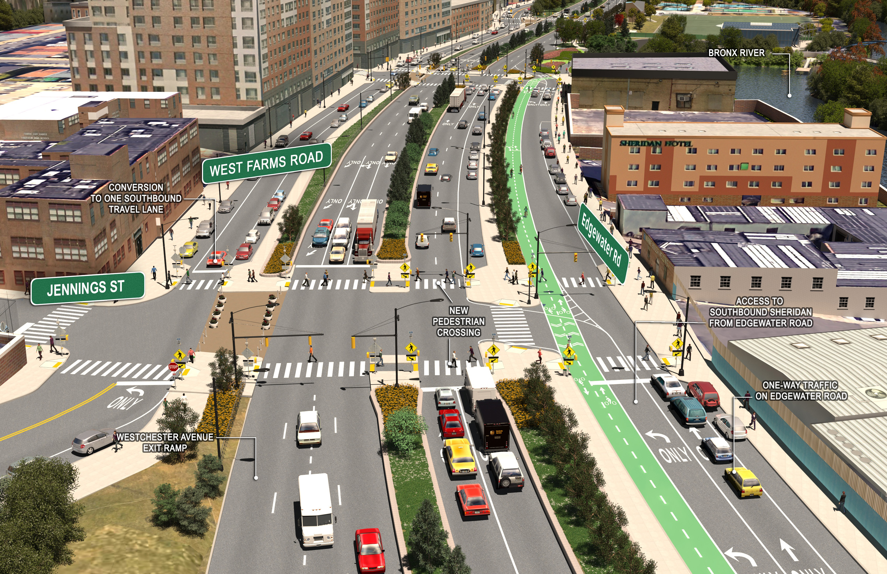
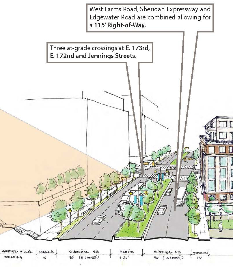
To ensure that the land use and transportation benefits of freeway removal were fully explored, New York City began the Sheridan-Hunts Point Land Use and Transportation Study of the Sheridan corridor in 2011, closely followed by the Alliance, and which is funded by a federal TIGER II planning grant. The final proposal was released in June of 2013 and is an attempt to reach a compromise between the residents' clamor for its removal and the Hunt's Point workers' traffic concerns. At this time, the city is looking into making modifications on the existing expressway to transform it into a boulevard. Some main goals are: to improve the connectivity of the expressway with the surrounding streets and communities, provide safe street crossings for pedestrians with extensive green buffers by sidewalks, increased affordable housing, and to create a public walkway along the riverbank running through a riverside park.
In March of 2016, the Sheridan Expressway Removal project was granted a $97 million boost in Albany's budget. In 2014 and 2015, the State Senate budget proposal allocated $3 million for an Environmental Impact Study for the project, but the item did not make the final state budget; now, for the first time, the state has agreed to fund the project.
In 2017, NYSDOT unveiled its plan to replace the Sheridan Expressway with a surface boulevard. Although the elevated expressway would removed, the boulevard slated to replace it still retained many highway-like qualities, including the same number of travel lanes as the expressway. Advocates worried that the wide design of the street would still prevent safe passage for pedestrians and encourage speeding. In addition, NYSDOT has proposed a $1.7 billion restructuring Bruckner Expressway with new ramps that cover part of the waterfront Concrete Plan Park. In September 2018, NYSDOT started work to dismantle the expressway. Originally work was expected to be complete by Spring 2019.