Disentangling the Loops


Downtown loop highways are a particularly egregious example of misplaced freeway logic. These overbuilt roads cordon off cities’ central business districts in an effort to ensure every square foot of downtown is accessible via highway. The Downtown Loop in Kansas City, Missouri takes this type of highway design to its extreme: the 4-mile loop, which encases an area of less than a square mile, has 23 different exits. The result? It’s nearly impossible for all but the most intrepid pedestrians and cyclists to cross from adjacent neighborhoods into downtown.
Fortunately, downtown highway loops offer low-hanging fruit for highway removal. They’re far from integral parts of a larger regional highway network. Rochester, New York has demonstrated just how beneficial this sort of transformation is. In 2017, Rochester removed the eastern portion of its Inner Loop. Since then, walking has increased 50 percent and biking 60 percent in the project area. In its first two years after completion, the Inner Loop East transformation, a $22m public investment, spurred $229m in economic development. These results are hard to argue with. Now, the city is looking to pick up where it left off and remove the northern part of the Inner Loop.
Freeways Without Futures 2021 tells the stories of the Highways to Boulevards projects in Rochester and Kansas City and their quest to disentangle the loop.
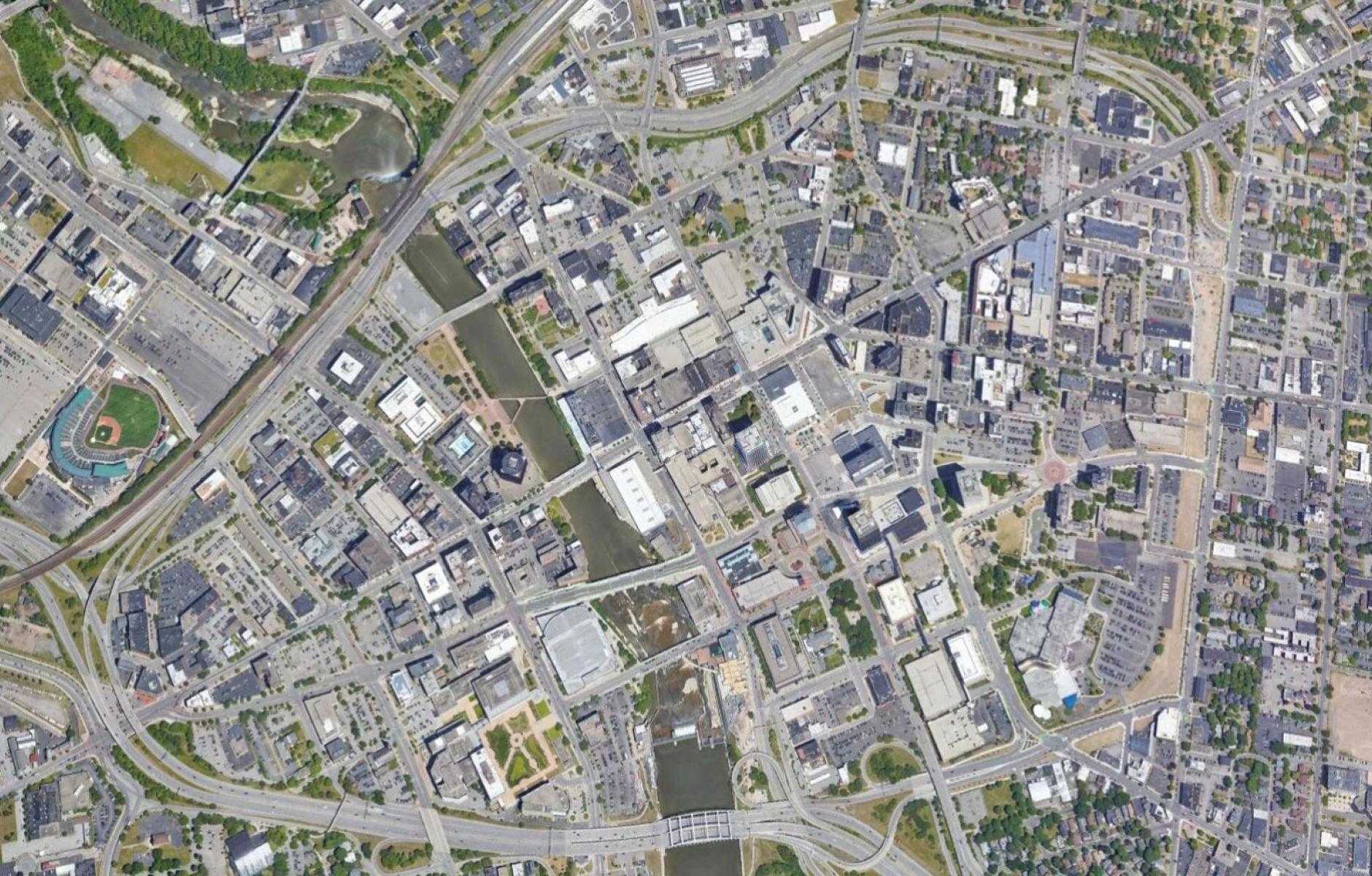
North Loop (I-35/70), Kansas City, Missouri
Many of Kansas City’s neighborhoods are effectively islands, divided by seas of asphalt and concrete. Nowhere is this more true than Kansas City’s Central Business District, which is penned in on all four sides by Interstate highways. The north side of this loop is particularly invasive, a tangle of ramps, interchanges, and highways that separate three neighborhoods: the Central Business District, River Market, and Columbus Park, from each other. Prior to the highways, Independence Avenue seamlessly linked all three neighborhoods.
Traffic studies undertaken as part of the Buck O’Neil Bridge rebuilding suggest that the removal of the North Loop, the redesign of Route 9 as a city street, and the reconnection of Independence Avenue between Columbus Park and River Market were all feasible without noticeably increasing travel times. This raises a significant question: if expensive highway infrastructure wasn’t necessary to serve Kansas City’s transportation needs, what else could be built in its place?
Beyond the Loop, a collaboration between the Mid-America Regional Council, the City of Kansas City, and the Missouri Department of Transportation (MoDOT), proposes several visions for the north side of downtown without the highway. It explores a range of options, from keeping the current highway to shrinking its footprint to removal and replacement with a restored Independence Avenue. Unsurprisingly, the removal option scored highest among all options in the categories of physical conditions, improved transportation choices, and improved economic vitality and placemaking, while only causing a slight increase in traffic.
Beyond the Loop also recommends other parallel projects that would go hand-in-hand with a North Loop removal and amplify its effects. Key among them is the removal of the elevated Route 9 and its replacement with an at-grade street. Once the Buck O’Neil Bridge is replaced, MoDOT projects Route 9 will only carry around 12,000 cars per day, which is less traffic than MoDOT estimates for many of downtown’s existing two lane streets. Rebuilding Route 9 as a street without highway-like qualities will not only restore connections between River Market and Columbus Park, but also remove the oversized cloverleaf interchange that connects it to the North Loop. Roughly five city blocks could be created from the land the interchange now occupies, an opportunity for incremental improvement before a possible North Loop removal.
Inner Loop North, Rochester, New York
With the Inner Loop North Transformation project, Rochester is seeking to replicate the success of the Inner Loop East removal and focus even more on creating outcomes that support a cohesive and inclusive community.
While the City has yet to commit to any specific design for the Inner Loop North project, it has laid out a set of guiding principles: it should improve connectivity, increase multi-modal transportation options, create new green spaces, and foster opportunities for economic and community development in surrounding neighborhoods, home to a predominantly Black and brown population. With a focus on racial equity, the project aims to prevent displacement of existing residents and businesses. Preliminary concepts estimate around 15 acres of land could be reclaimed for development, along with several acres of green space.
A group of community members, Hinge Neighbors, is also working with residents on both sides of the Inner Loop to raise awareness about the impacts the project will have and communicate local needs and desires to the City and its consultants. To gather more information, they’ve launched a community survey, which has had some telling results. One of their significant findings is residents’ desire for housing that better fits neighborhood character and different living situations. Four story buildings, full of one- and two-bedroom apartments, don’t address the needs of all community members, even if they include affordable units. Residents would rather see a mix of housing types, including smaller homes that are often described as ‘missing middle’ housing. The City and its partners should take this into serious consideration as they think about creative options for affordability and avoiding displacement following removal.
Rochester’s success with the Inner Loop East garnered national attention. With the removal of the Inner Loop North, the city has the opportunity to once again be at the forefront of the Highways to Boulevards movement. It should lead the way by doing everything in its power to listen to residents and incorporate their ideas into the project’s final designs. At the same time, the City should also explore all the policy tools it can use to support residents and their visions. If Rochester follows through on these commitments, it will be a model for future highway removal projects prioritizing equity.
To learn more about the other highways in Freeways Without Futures 2021, download the report here.


