The return of the parkway


Prior to the Interstate era, the landscaped parkway was the predominant way to get in and around cities. Examples from this earlier period, like the Emerald Necklace in Boston, show that parkways can carry substantial traffic and provide a pleasant setting for recreation even as traffic moves safely along them.
Today, the term has been corrupted and many so-called parkways have effectively become highways. Freeways Without Futures 2021 features several Highways to Boulevards projects that seek to reclaim the concept of the parkway and build new ones that adhere to their original design principles. In Duluth, the Duluth Waterfront Collective has revived plans for a parkway that connects the city back to Lake Superior. In Buffalo, the Scajaquada Corridor Coalition advocates for a safer street through Delaware Park that’s easier for park goers to cross. And in San Francisco, the Great Highway Park Initiative seeks to reinvent the idea entirely, turning the Great Highway, already closed as a car-free slow street, into a permanent park. For each, the goal is to balance recreation with transportation:
Interstate 35, Duluth, Minnesota
In Duluth, the 1,569-mile long I-35 comes to its northern terminus. It ends unceremoniously at a four-way intersection, but not before it bisects Duluth’s downtown and separates it from its Lake Superior waterfront. A coalition of residents, the Duluth Waterfront Collective, is seeking to restore this connection and create a more vibrant city center by replacing the highway with a street that integrates downtown and the waterfront.
Current conditions make it very appealing to remove the portion of I-35 that runs through downtown, which the Duluth Waterfront Collective advocates for. Traffic on the highway is incredibly light for an Interstate, totaling only 32,000 trips per day. Meanwhile, the Canal Park neighborhood and the preserved green space along the waterfront have become some of the most visited places in Minnesota, yet much of the Duluth community is unable to enjoy it as an amenity. With limited places to cross, the highway limits local travel to and from Canal Park, with the result that few of the park’s visitors make their way into Duluth’s downtown and spend money there. Uphill from downtown is Duluth’s Central Hillside neighborhood, which is one of the city’s most diverse. It has a high number of residents living in poverty, many of whom do not own cars. The presence of I-35 limits their enjoyment of the waterfront as well.
As a replacement for the highway, the Duluth Waterfront Collective envisions a new parkway that condenses I-35 and Railroad Street, but would only increase through travel times by a few minutes. The parkway is planned to be much more accessible to pedestrians and cyclists, with wide sidewalks lined by trees and a new cross-city recreation trail. Its current iteration calls for dedicated space for bus rapid transit, and includes a rail corridor for the local tourist excursion train and potential future transit options. In the center of the parkway, a landscaped median will provide even more green space in addition to capturing stormwater from the hillside and floodwater from the lake.
Scajaquada Expressway, Buffalo, New York
Visit Buffalo’s popular Olmsted-designed Delaware Park and you’ll find you have to cross the Scajaquada Expressway to get from one side to the other. The centerpiece of Buffalo’s parks system designed by Frederick Law Olmsted and Calvert Vaux in the late 1800s, Delaware Park today remains a favorite recreation spot for Buffalonians. Given the park’s sustained popularity, the construction of the high-speed Scajaquada Expressway through it in 1962 might come as a surprise to many. But the City of Buffalo Planning Commission that initiated the project justified the route because it viewed the park as ‘vacant land,’ not a community asset.
Community stakeholders have been vocal that the removal of the Scajaquada Expressway goes beyond getting rid of a dangerous roadway; rather it is a step toward realizing Buffalo’s future potential and increasing its residents’ quality of life. Numerous regional assets are located along the corridor and currently separated by the highway, including many of Western New York’s key cultural and educational institutions and the suppressed Scajaquada Creek.
As designs for a new street through Delaware Park move forward, the Scajaquada Corridor Coalition is committed to restoring the legacy of a park and parkways system that connects Buffalo’s vibrant communities, treasured historic landscape, and healthy waterways along a corridor where all modes of transportation are safe, accessible, and welcoming.
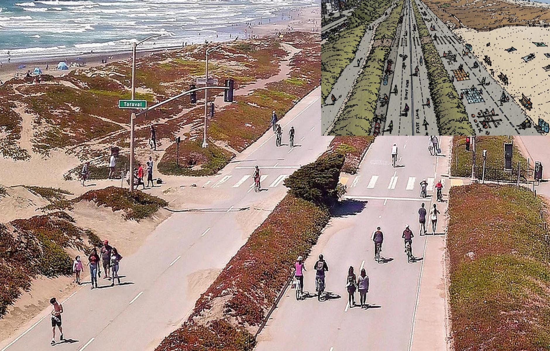
The Great Highway, San Francisco, California
The Great Highway may lack the Interstate designation that many other of the highways in this report carry, but it still exhibits similar qualities: limited access, speed as a priority, and a barrier to access. But all of this changed in April 2020, when the road became a popular car-free slow street to facilitate social distancing. As the city debates whether or not to reopen the Great Highway to traffic, some residents wonder if it would be better to keep it closed permanently.
Even prior to the pandemic, San Francisco’s Great Highway was already closed. The 3.5 mile-long commuter road sits adjacent to the dunes along the Pacific coast and every time it’s overwhelmed by sand or erosion, it is forced to close -- sometimes for as much as 30 percent of the year. So, when the San Francisco Municipal Transportation Agency (SFMTA) started identifying potential car-free streets to enable social distancing, the Great Highway became an obvious choice.
As a pedestrian-only space, the Great Highway has achieved notable success. SFMTA collected data on the street’s usage from September-November 2020 (i.e. the offseason) and found an average of 6,800 bicyclists and pedestrians per weekend day. In essence, the street has become a flexible public space where some people still use it for transportation (albeit on bicycle), others recreate, and it has even served as a site of Black Lives Matter rallies and a march against Asian American and Pacific Islander hate.
The Great Highway Park Initiative also advocates for a few simple and inexpensive changes that would vastly improve the Great Highway as a park/bikeway. The addition of basic amenities, such as water fountains, trash and recycling bins, and places to safely lock bicycles could drastically improve the usability of the park.
Because of the park’s popularity, the SFMTA has initiated a study to explore the long-term future of the Great Highway. Meanwhile, thousands of visitors each day will continue to enjoy the Great Highway as a park and demonstrate the need for this unique community space.
To learn more about the other highways in Freeways Without Futures 2021, download the report here.


