I-81 transformation begins in Syracuse, but design is still an issue


The City of Syracuse and the New York State Department of Transportation (DOT) agree that a "community grid" best replaces the aging Interstate 81 viaduct that has divided the city since the 1960s. Despite an ongoing court challenge from opponents, the state started clearing trees in July to prepare for the project—and the governor this month opened offices for community feedback in Downtown and Southside Syracuse.
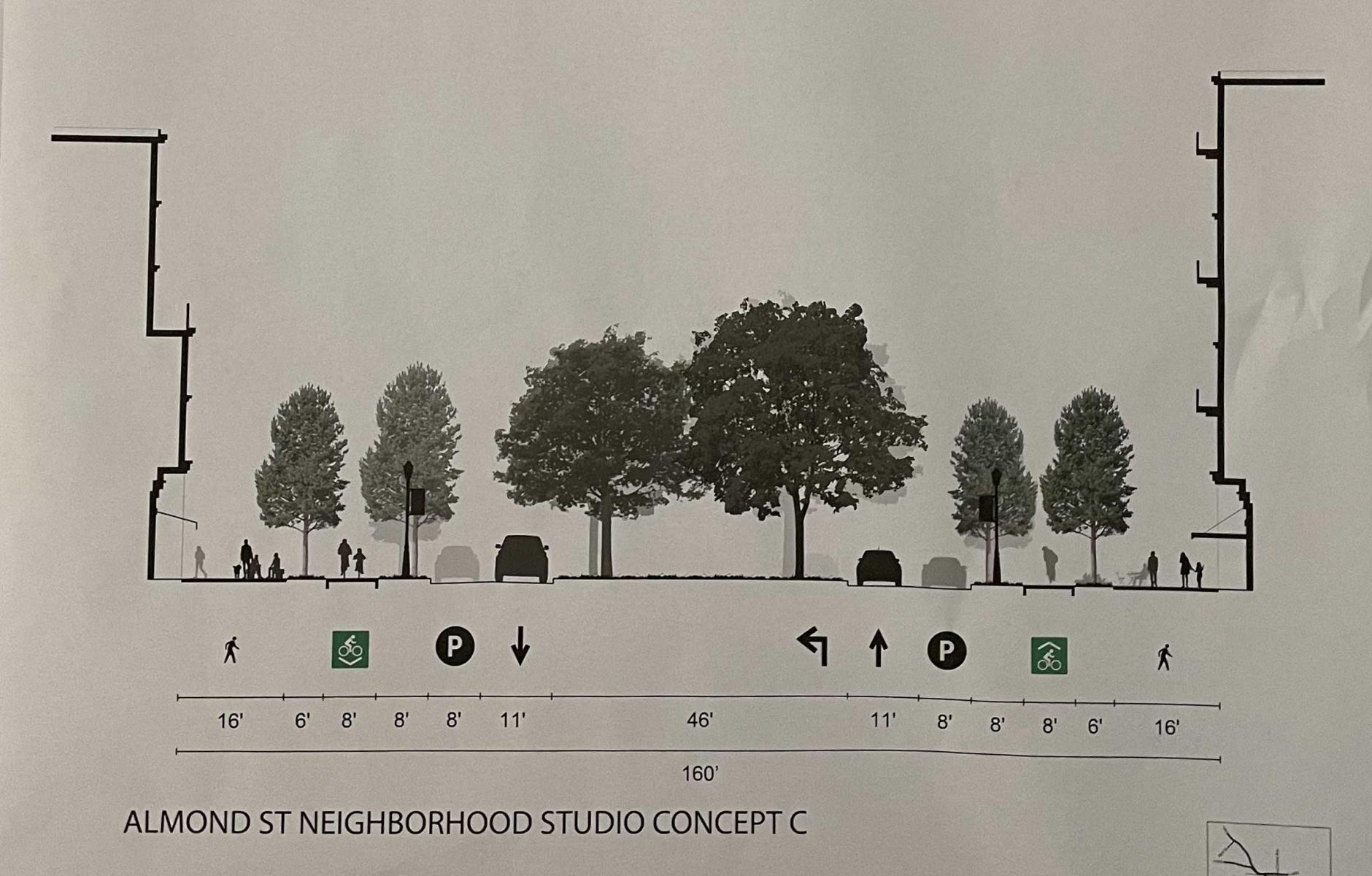
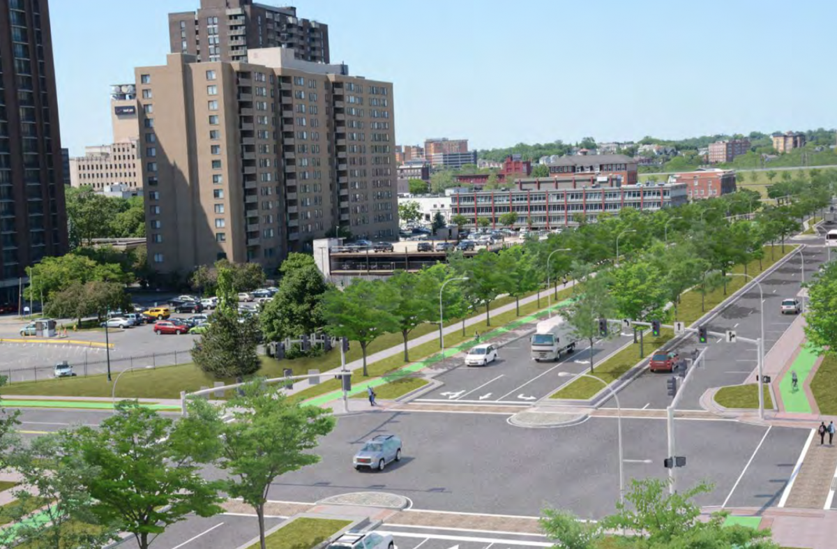
The DOT's local public outreach points to an ongoing question—what will the "community grid" look like? When the state released designs in 2019, they showed a wide arterial thoroughfare, typical of many suburban arteries. That choice doesn't come with many benefits for people on foot. The city hired urban planners Dover, Kohl & Partners to examine other options.
Agreeing on a strong design that supports a multimodal street network is critical for the future of this historic city that anchors the Central New York metro area. "It's going to change the city for 100 years; that's why it is important," says Josh Frank, project manager for Dover Kohl. "Cities don't get a chance like this very often—most of the time, it's due to a disaster, trauma, or even war. For a city willing to reinvent itself on this scale, it's not common in the US."
In other words, this is not just another transportation project. For residents, the economy and character of their neighborhoods and downtown will greatly impact the community grid and how it is designed.
Syracuse is pushing for a community grid that is walkable and connected, reflected in the work of Dover Kohl. "In their initial drawings, they've addressed many areas of opportunity for us, and articulated a vision that speaks to much of what we had hoped to see," says Joe Driscoll, the "I-81 Czar" for the city.
If the project is vital to Syracuse, the issue is also important nationally. "In every highway-to-boulevard campaign that has been remotely successful, the struggle has been in pushing the envelope toward good urbanism, road-dieting, and a true boulevard," says Frank. "That means making the design more like a street in a city and less like a road in a suburb."
The Congress for the New Urbanism has been a leader on this issue through its biennial Freeways Without Futures reports. I-81 in Syracuse is the only highway that made the first seven CNU reports since 2008 (Because the state has agreed to demolish the viaduct, the section of highway was not on CNU's eighth biennial report, published in 2023). The elevated highway's inclusion in the early reports helped to get the ball rolling for the viaduct transformation.
A broad coalition of Syracuse public officials, citizens, and private groups have carried the idea forward over the last decade. In 2019, NYSDOT announced that the viaduct would be replaced by a grid of streets, in lieu of a more costly rebuilding of the current infrastructure. I-81 traffic would be rerouted on the current I-481 around the city, and I-690 still would provide Interstate access to downtown.
To propose alternatives, Dover Kohl held a design charrette in late August, 2022. A stronger focus on urban design allows for more interesting design possibilities.
More trees along the corridor are a key aspect of people-friendly infrastructure, says Driscoll. "Trees are as important as the accommodations for pedestrians, bikes, and public transportation. One of the main things that makes the current viaduct corridor so unwelcoming is the lack of tree canopy."
And yet, this project has significantly more potential than just Almond Street. Taking out the ramps connecting I-81 to I-690 (and providing better access from I-690 to downtown a couple of blocks east), will make available dozen or more city blocks for urban development. "There are 12 to 15 blocks that will open up, and that doesn't count redevelopment—because there's a lot of empty land around 81 and 690," Frank says.
How these blocks are shaped and organized will be important for the city's economic development. A balance needs to be struck between blocks that are too small—therefore difficult to develop—and sites that are too big and lack a fine-grained urban fabric. In the charrette it was reported that Rochester, New York, made the latter mistake after removing a segment of its Inner Loop freeway in 2016. Parcels offered for redevelopment were too large, creating a uniformity of appearance of new buildings (that said, demolishing the Inner Loop is considered a success).
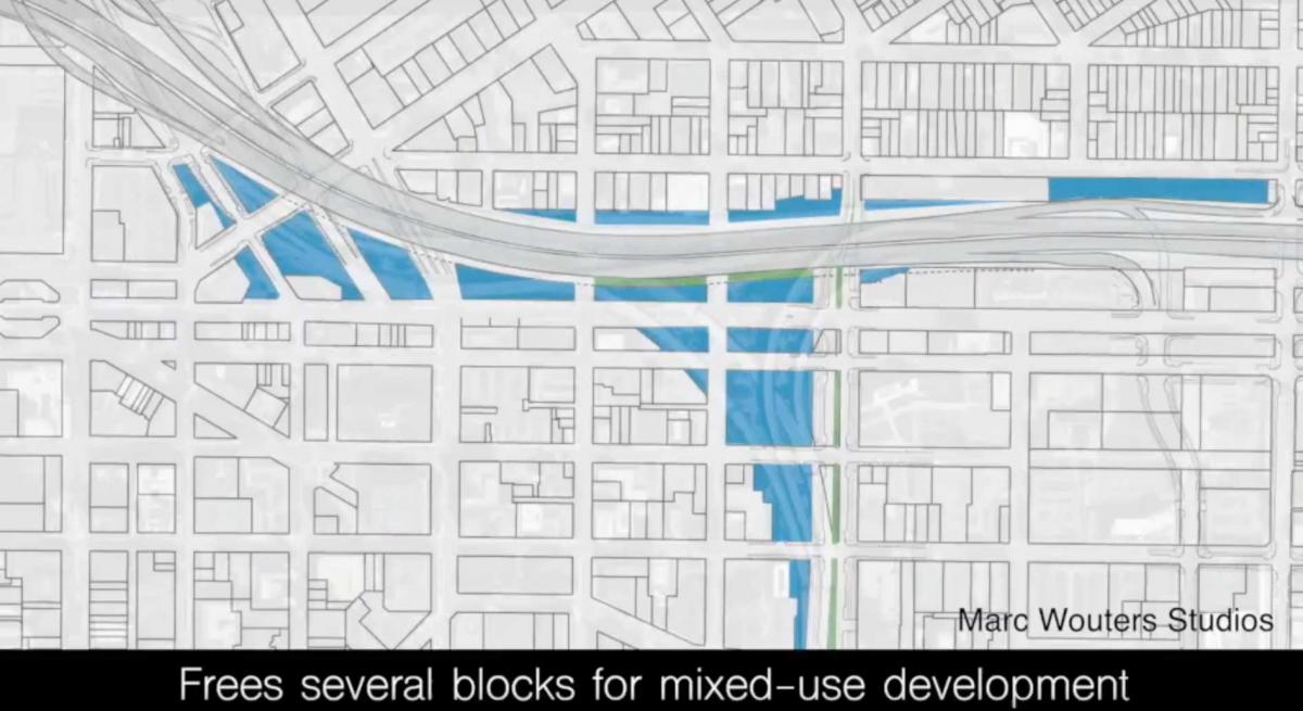
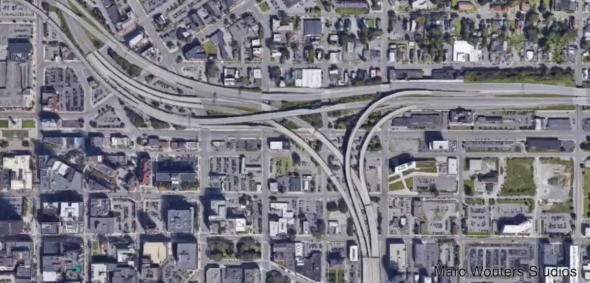
At top, some of the blocks, shown in blue, available for redevelopment from taking down the I-81 viaduct. Immediately above is a satellite photo of the current highway interchange with I-690. Source: Marc Wouters Studios.
The form of the I-81 corridor redevelopment—particularly how the buildings front the street, their scale, the uses and services provided, and whether they allow for a broad mix of people and activities—represents a planning challenge to Syracuse for decades to come. The city, fortunately, recently rewrote its zoning ordinance, which dated from the 1960s. The new regulations will help determine the mixture of uses and the appeal of the public realm.
Planning the redevelopment of the highway corridor also raises critical social and environmental issues. Pioneer Homes, one of the nation's public housing projects, is planned for redevelopment on a similar timeframe as the highway transformation. The plan calls for 1,400 mixed-income living spaces (many affordable), and a one-to-one replacing of the public housing. "Starting with anti-displacement, housing, equity, resilience, public space, parks, and tree canopy first, we are hearing from the community on what they want to see," Frank says. "Then we reverse engineer the street and public realm to adhere to those values, rather than vice-versa."
While DOT designs often seem to squander the right of way, Dover Kohl is looking carefully at every fraction of a foot. "Every inch matters greatly because we are leveraging the public right of way into private investment, jobs, quality of life, and health and economic mobility—we are trying to squeeze a lot of juice out of that lemon for other things," Frank says. The precise width of the parking lanes, for example, may influence the design speed of the street—which could make the difference between attracting or repelling pedestrians (and whether they use public spaces or visit shops).
Development along the corridor depends on real estate markets in the city. Plans for an enormous Micron microchip facility were announced for the region in September of 2022, and they will have an impact. The $100 billion project is expected to create 9,000 high-paying jobs and as many as 40,000 ancillary positions in the Syracuse region. Micron changes the economics and development potential for downtown and the opportunities created by rerouting I-81.
The I-81 viaduct transformation has been a long time coming. Despite DOT's 2019 decision, there is still a lawsuit pending on demolishing the viaduct, brought by opponents in some towns outside of the city. While the project is likely to go forward, the delay may be working to the city's advantage in one respect: It is giving Syracuse more time to design a better community grid. "We are always looking for ways to make the project better—and I think DOT is looking to do the same. There is still time to design, and we want to make the street the best it can possibly be," Frank concludes.
"After so many years of study and debate, the process to replace I-81 with a community grid is ramping up," says Rachel May, who represents the city in the State Senate.
Editor's note: This article addresses CNU's Strategic Plan goal of growing the supply of neighborhoods that are both walkable and affordable.
