For cities and streets, 101 salvations


In 2012, in a book called Walkable City, Jeff Speck set out to help small and mid-sized communities provide their residents “a quality of life that makes them want to stay.” As Speck saw it, some big cities, including New York and Portland, Oregon, had been making impressive strides toward good urban design, but in smaller communities, officials’ daily decisions were, “more often than not, making their [residents’] lives worse.”
Walkable City, with its on-the-ground stories and its spirited advocacy of pedestrian-oriented design, was a lively, highly readable guide. Drawing on his experience first as head of town planning for DPZ, then as director of design for the National Endowment for the Arts, and most recently as an independent planning consultant, Speck set forth a “General Theory of Walkability” and instructed municipalities on how to attain a high-quality built environment. The one thing missing from Walkable City was illustrations.
Now Speck has produced a successor volume, Walkable City Rules. It abounds with illustrations—charts, graphs, photos, maps, plans. The text itself is organized into short pieces—each only a page or two long—supplying concise guidance on 101 topics.
On recent American urban development, Speck writes: “The happy news is that the trends are positive … . To the degree that it is practiced in American communities, city planning is now doing more good than harm.” But, he points out, “the results are incredibly spotty.” Thus, the new book, which takes Walkable City’s ideas and organizes them into bite-size pieces—easy to look up and cogently worded so that you can use them to influence the local planning commission (or anyone else that needs to be persuaded).
Many people, from planners to ordinary citizens, are talking about “walkability” these days, so I’m glad that Speck has defined what it is exactly that makes a place walkable. His analysis is that “to be favored, a walk has to satisfy four main conditions: it must be useful, safe, comfortable, and interesting.”
- Useful means that most aspects of daily life are located close at hand and organized in a way that walking serves them well.
- Safe means that the street has been designed to give pedestrians a fighting chance against being hit by automobiles; they must not only be safe but feel safe (a more difficult standard to satisfy).
- Comfortable means that buildings and landscape shape urban streets into “outdoor living rooms” rather than produce wide-open spaces, which usually fail to attract pedestrians.
- Interesting means that sidewalks are lined by unique buildings with friendly faces and that signs of humanity abound.
Each of those conditions is essential; none, by itself, will make a place truly walkable.
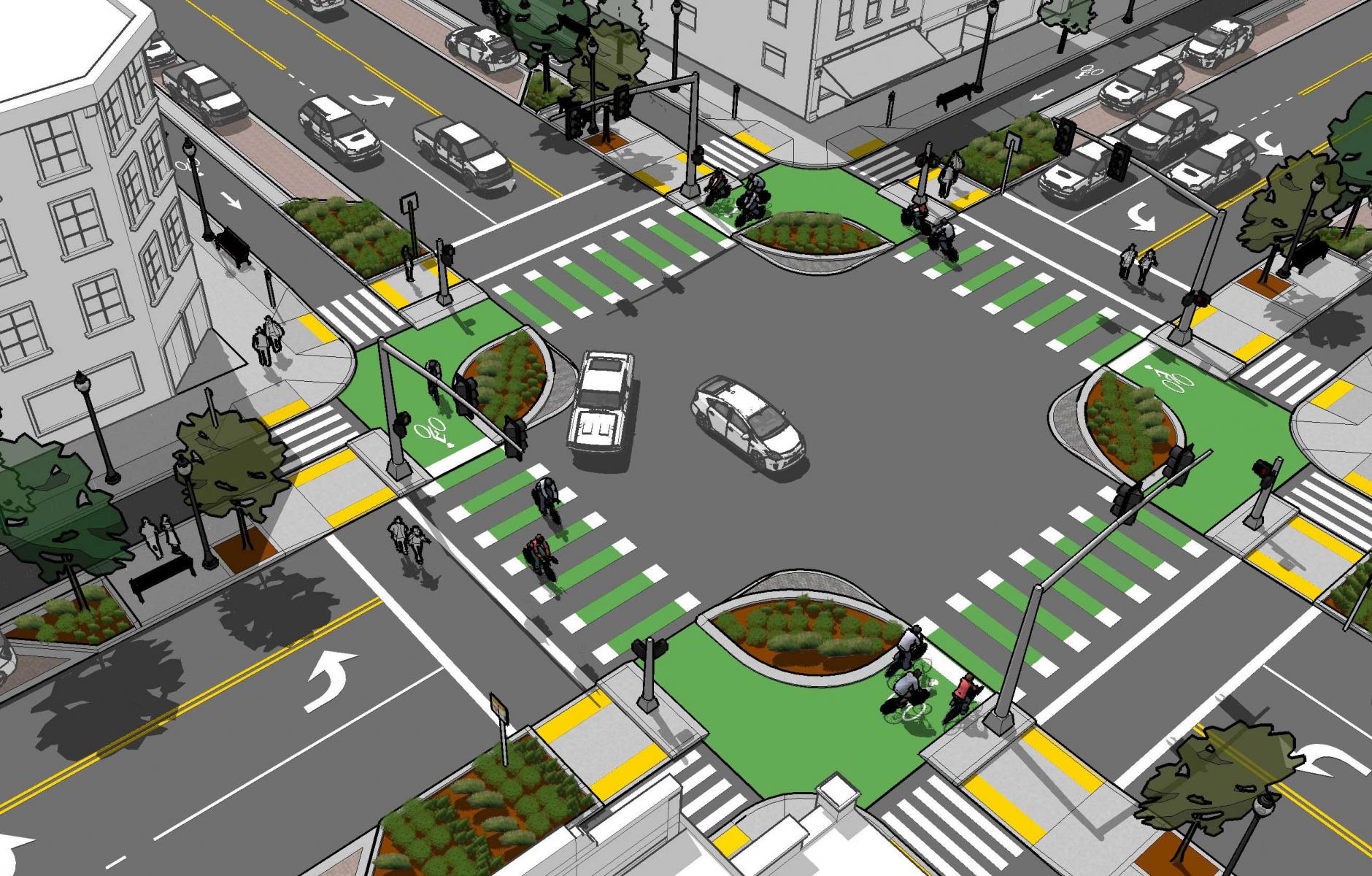
Walkable City Rules opens with big, central ideas—sell walkability; mix uses; making housing attainable and integrated; get the parking right; make transit work; escape dependence on automobiles—and progressively works down to more detailed recommendations. After being educated about fundamental principles, the reader is given details and specifics: how wide to make the driving lanes on a downtown street, how to stripe a center turn lane so that it doesn’t encourage speeding, how to make an intersection that will be comfortable for cyclists and pedestrians as well as motorists.
Reduce speeds to save lives
Roughly half of the 101 steps to a walkable community address aspects of the street and how it should be designed and managed. A chief objective is to control (and generally reduce) vehicle speed. “The basic message to remember,” he says, “is that you are about five times as likely to be killed by a car going 30 as a car going 20, and five times again as likely to be killed by a car going 40.”
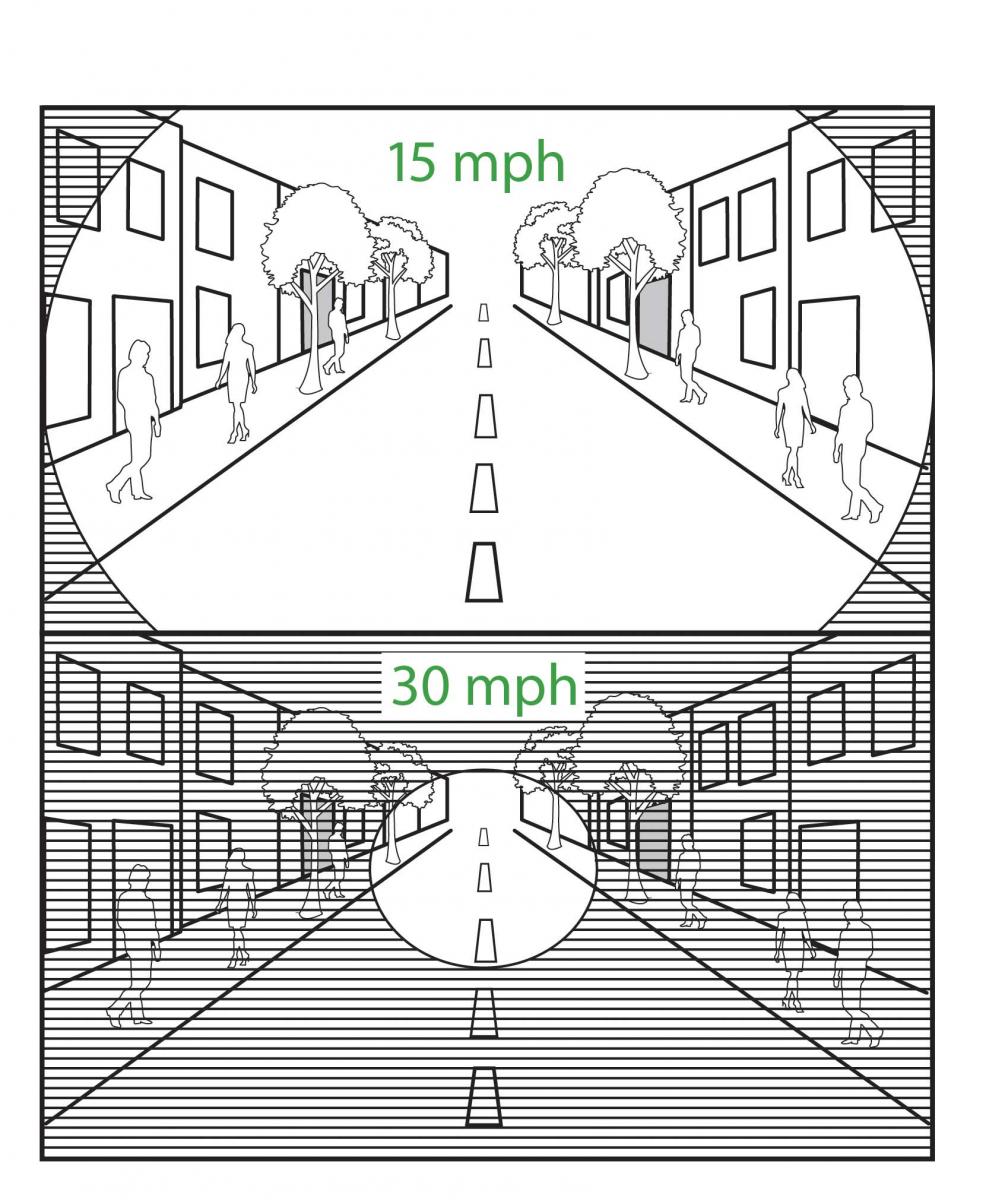
Downtown, the speed limit should be 25 mph or possibly even 20 mph. Don’t propose “slowing drivers down,” he advises. “Who wants to be slowed down? That sounds like congestion. Instead, we can simply talk about ‘reducing illegal speeding.’ Streets need to be redesigned so that fewer people will speed on them.”
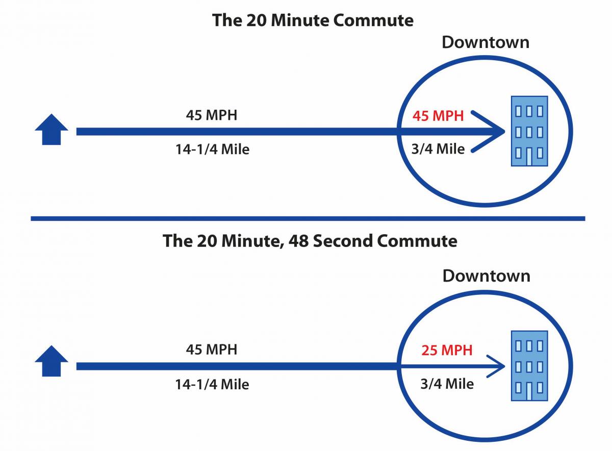
Trade-offs must be made between commute time and safety, but overall, the benefits of slower speeds greatly outweigh any time lost, he argues. Would you rather have a downtown that’s quick to drive through, or one worth arriving at? That is a key question. “People avoid sidewalks they don’t feel safe on,” Speck emphasizes, “and without people on sidewalks, cities don’t thrive.”
The book pulls together examples from the US and other countries. “For some time, the leadership of the Swedish traffic safety profession has acknowledged that street design is at the heart of street safety, and modified its engineering standards with an eye to lowering speeds in urban areas,” Speck relates. “The results are astounding. Their traffic fatality rate as a nation is about one quarter of the United States’, but the biggest difference is in the cities. In 2013, Stockholm, with a similar population to Phoenix, lost six people to car crashes. Phoenix lost 167.”
New York City has made quite a few wise trade-offs between commute time and public safety. On Queens Boulevard between 1990 and 2014, 186 people were killed in car crashes—roughly one death ever seven weeks for a quarter-century. Most of the victims were people walking. Finally, the city spent $4 million to improve pedestrian and cycling facilities; “not a single person has died since,” Speck reports. “Speeds have dropped by about 4 mph along the corridor. Few would argue that this slight inconvenience is worth even a single life.”
One way to make people more conscious of a speed limit is to create a public campaign for a limit that applies to an entire area, especially a well-defined section such as downtown. “Having a catchy name doesn’t hurt either,” says Speck. “That’s why the 20’s Plenty for Us movement has had such an impact. More than 15 million people, most of them Britons, live in jurisdictions that have adopted or will soon adopt neighborhood-wide 20-mph speed limits. About one third of London is now so posted.” Portland, Oregon, recently established a 20-mph limit on 70 percent of the city’s street miles.
Red-light cameras and speed cameras—automated devices that issue citations to drivers who run red lights or exceed the speed limit—also save lives. So far, red-light cameras have been installed in 421 US communities and speed cameras have been installed in 142. Results? “In Seattle, a red-light camera program led to a 23 percent decline in collisions, while crashes involving pedestrians fell by almost a third,” Speck says. “The cameras even reduced rear-end crashes by 15 percent, which is meaningful, given past speculation that cameras would cause an increase in rear-enders.”
Many streets remain too wide
“The more driving lanes a street has, the more dangerous it is,” Speck says. “A key approach to keeping a place walkable is to resist pressures to add more lanes, and a key technique for making a place walkable is to remove any lanes that can be cut without unduly impacting the experience of drivers.” To do that, it’s important to hire the right engineer. “Most often, this means bringing in a consultant who is prepared to counter the often-incorrect assumptions of local public works officials,” Speck observes.
He contends that almost all American cities, even congested ones, contain at least a few important streets that have more lanes than they need, given the volume of traffic. “These lanes,” he says, “are doing nothing but wasting asphalt and causing mayhem. When this fact is properly communicated, they can be removed.”
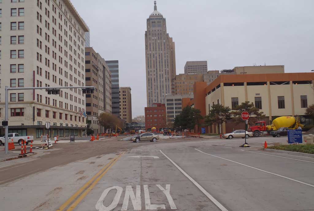
That’s precisely what happened In Oklahoma City, which had been named the “least walkable city in the entire country” by Prevention magazine. Seven streets running through downtown were four to six lanes wide, despite averaging fewer than 7,000 car trips per day. Mayor Mick Cornett then commissioned a walkability study, which determined there was a mismatch between the supply of lanes and the demand. This led to right-sizing the streets, converting driving lanes to on-street parking (which proved beneficial for businesses), and creating landscaped medians and a bicycling network. Speeds decreased. Safety was enhanced.
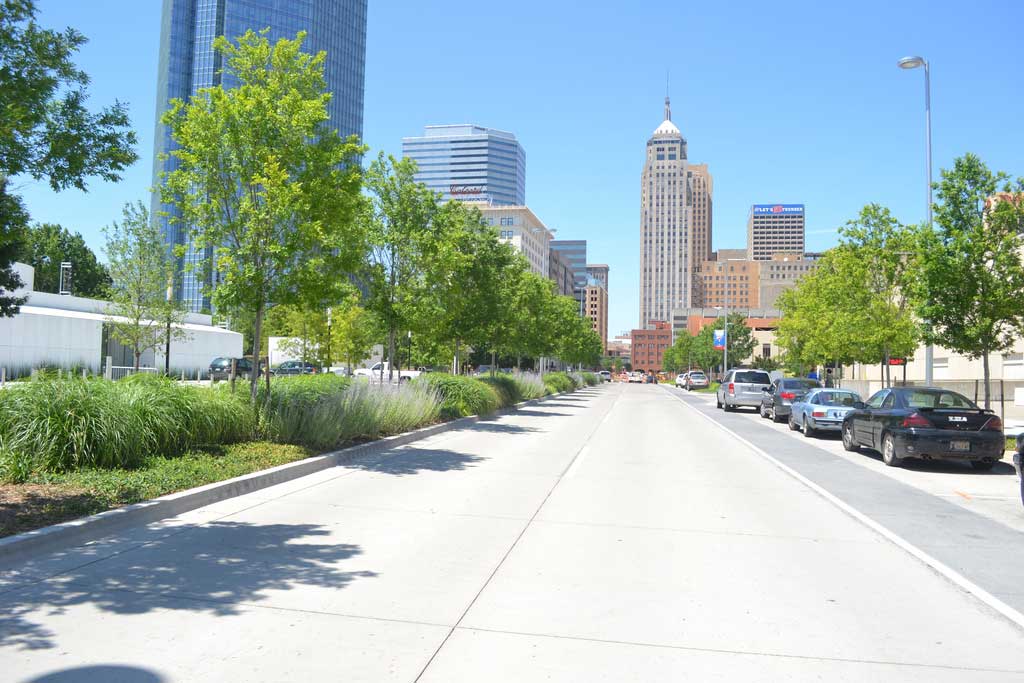
Speck is a fan of “road diets,” which take unneeded driving lanes and convert them to other uses. Seattle has carried out 34 such diets. Most commonly, these regimes convert four-lane streets into three-laners. When Telegraph Avenue in Oakland, California, was slenderized, retail sales rose 9 percent, probably because the volume of pedestrian activity doubled. A road diet can cut traffic injuries substantially without reducing the road’s capacity, he says.
“Perhaps the key step to making our communities walkable again is to get our driving lanes back to their historical proportions,” he says. “This means busy urban lanes that are only 10 feet wide—not 11 or 12—and the reintroduction of slow-flow and yield-flow streets with lanes that are even narrower.”
A slow-flow street is one that forces a driver to slow down when approaching another car. Its lanes are about eight feet wide. “The discomfort aroused by passing without braking is what makes it considerably safer than a free-flow street,” the author explains.
A yield-flow street is one in which a single driving lane about 12 feet wide handles travel in both directions. “This sounds preposterous,” Speck says, “which is one reason why they were eradicated by people who clearly did not have eyes to see, since they exist almost everywhere and are inevitably the most desirable streets in any city.”
Lanes became too wide because “in the second half of the twentieth century, city engineers began importing highway standards into their downtown cores,” Speck says. On 12-foot lanes in Omaha, “drivers can be observed approaching highway speeds,” he points out. “Any lane that is wider than necessary should be understood as a health risk … . Responding to that risk should be made an explicit mandate of fire departments and other emergency services.”
Transit agencies could be enlisted in the initiative, too. Speck reports that administrators of DART, the Des Moines transit agency, advocate for 10-foot lanes, aware that “every transit ride begins and ends with walking, and without walkable streets we are undermining the opportunities for public transit in the community.”
The downside of roundabouts
Not every recent innovation merits Speck’s full approval. The City of Carmel, Indiana, has installed more than 100 modern roundabouts as an alternative to conventional signalized intersections. “They have reduced injury accidents in this upscale Indianapolis suburb by more than 80 percent and do a tremendous job of handling large amounts of traffic,” Speck acknowledges.
But even Carmel has been careful to keep them out of downtown because, he says, “roundabouts are not exactly urban.” Several features make roundabouts feel less walkable than traditional intersections. Speck enumerates: “First, they ask people who are trying to walk in a straight line to divert well to the side, and then back again, in order to keep moving across town.
“Second, while they require cars to slow and yield to pedestrians, vehicles never actually come to a full stop unless something is blocking them; roundabouts feel dynamic, and pedestrians prefer environments that are static. Third, they introduce into urban areas a design vocabulary which is unavoidably automotive; they swoop.” Altogether, then, Speck sees roundabouts as “a great tool, as long as the intention is not to create or reinforce a sense of urban vitality.” Speck’s ability to identify pros and cons and to sum things up in trenchant fashion is one of the reasons why Walkable City Rules keeps readers engaged from beginning to end.
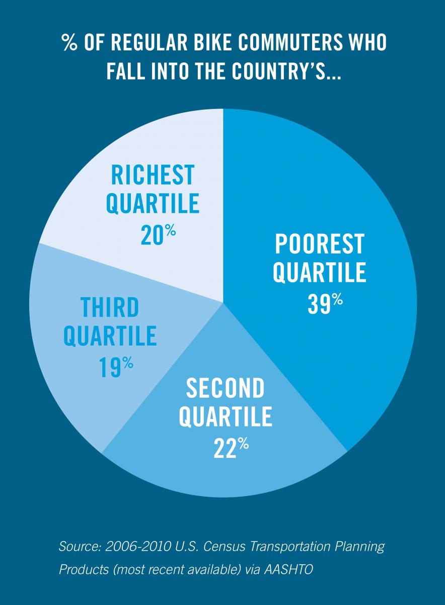
One other thing stands out: an awareness of social justice, of the need to pay attention to how community design and development affect people of modest means. In discussing cycling facilities and bikeshare programs, Speck draws attention to the fact that biking to work is not the preserve of the relatively well off. On the contrary, “poor people are almost twice as likely to bike to work. The lowest-earning quartile of Americans make up almost 40 percent of the bike commuting population.”
From this, Speck deduces that making investments in bike facilities will “disproportionately improve the safety of your community’s construction laborers and restaurant workers, and help to free them from the huge financial burden of car ownership.” That’s an interesting point—one that hadn’t occurred to me despite my years of biking the streets of New Haven.
Speck opens a reader’s eyes to how urban environments function, the good and bad that they do, and how we can make our communities better. His book deserves the widest possible readership.
Walkable City Rules: 101 Steps to Making Better Places, by Jeff Speck, Island Press, 308 pp., $30 paperback.