A village starts with a street plan


A recent Substack piece, “How to Build a Village,” caught my attention because it features a site near where I live. The “village style” plan in Clay, Onondaga County, New York, was highlighted by planner, ex-mayor, and writer Bill Fulton (The Future of Where, which I highly recommend).
Clay is the site of Micron’s massive $100 billion plant under construction, designed to be North America’s largest semiconductor factory. Needless to say, this plant will transform the real estate market in Clay and the surrounding region, centered on Syracuse, New York. It will fuel demand for a whole lot of new housing. The site of the “village style” plan is Three Rivers Point, one of the prime spots for potential urbanism in the area. That’s where the Oneida River joins the Seneca River to form the Oswego River. The town envisions a mixed-use waterfront development with public space, inspired by historic villages in Central New York.
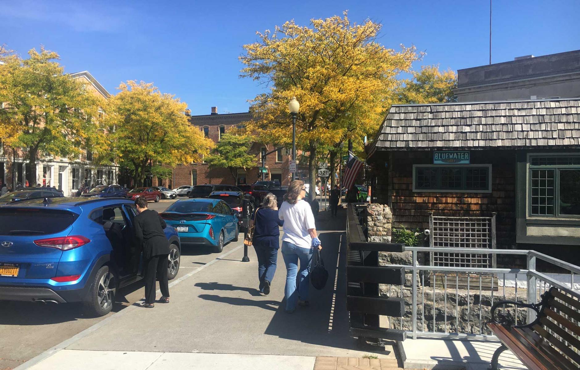
Fulton mentions the beautiful Village of Skaneateles, also in Onondaga County, as an ideal to aim for (see the photo at the top of this article). Clay needs more than zoning reform to make the project successful, Fulton points out, explaining that three other factors are key:
- A variety of housing types
- Retail that will attract customers from beyond the village itself
- Developers who are willing to take this on
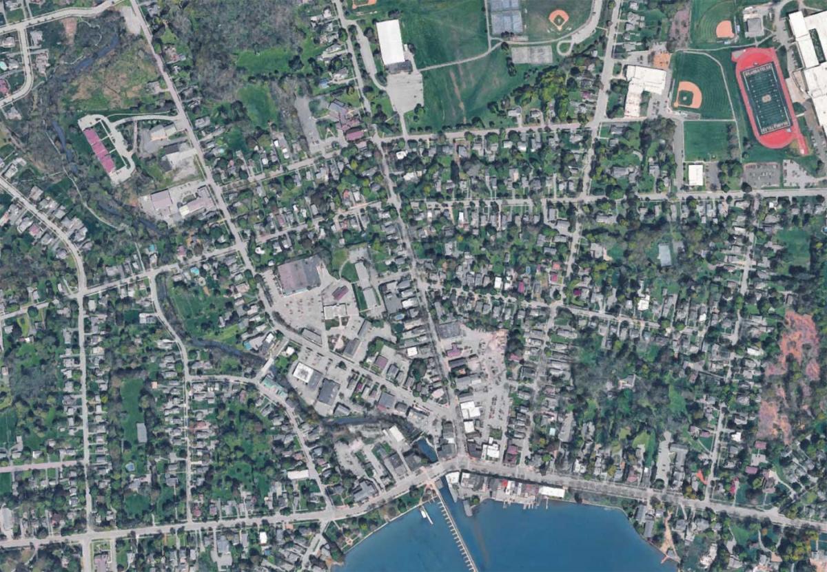
That’s all true, but the village needs something else besides: A walkable urban form. Skaneateles has that form in spades. The village was founded in the early 1800s and built to be walkable. Above is Skaneateles’s block-and-street pattern from Google Earth. The network is walkable and human-scale, providing a great foundation for a village. Genesee Street, the main street, skirts the lake's edge, which gives the village its charm (despite being a segment of US Route 20, a federal highway).
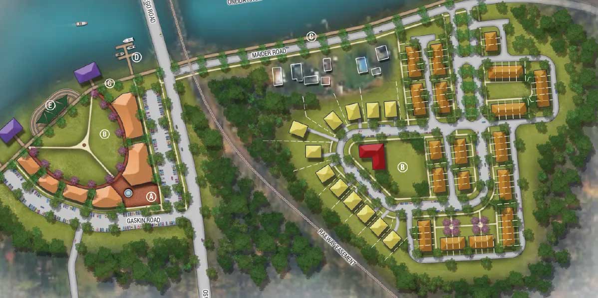
Clay’s “village-style” plan was commissioned by the Town to demonstrate the concept. The Town received a state grant to plan a mixed-use waterfront community. The plan has a variety of housing types—including single-family, townhouses, and apartments. It also has a nice waterfront park (see the partly oval area on the left of the plan above). The Town must reform its zoning to make the plan feasible, and a developer willing to build it must be found. It is questionable how much retail it would support. To me, the plan didn’t look like a historic village, so I decided to analyze the block and street network by drawing it. Below is what I found:
The residential area, on the east side, is revealed by the analysis to be an insular pod. There is one entrance from the road along the river, from which it will look like a conventional development. It does have some public space, but that can only be seen and used from inside the project—a grouping of townhouses and single-family houses. Therefore, it would only serve the people living there, who will likely drive to and from the site. On the left, the waterfront park will be surrounded by a semi-circle of apartment buildings. The park would likely be a nice event space, and a restaurant might work there—but as urbanism, it doesn’t amount to much. I highly doubt that the site would support retail that would attract customers from beyond the village, as Fulton suggests.
To put it plainly, the village-style plan created for the site is not a village. It’s not a lively, mixed-use waterfront community. It’s a nice park with some planned residential development. That’s it.
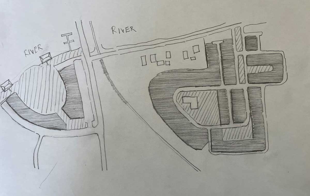
I decided to draw a rough street plan to show how a village might be laid out for Three Rivers Point. Mind you, I am not an urban designer, and this is not a real plan. Considerably more analysis would be needed, including an examination of lot lines and testing the blocks to ensure they can accommodate the anticipated range of buildings and parking. A public process would be needed. A skilled urban designer would do far better. Yet this sketch plan shows how village streets and public spaces could be designed on the site.
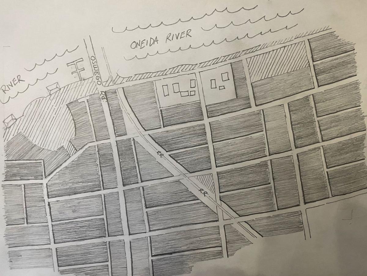
Notice how the blocks are linked together in a grid or connected network—like historic New York villages. That is far different from the existing proposal. The blocks are about 260 feet north to south and 400-500 feet east to west—dimensions typical of walkable urban blocks. I added alleys, which are rarely found in New York State. The alleys would make the site easier to develop and add another layer of connectivity. The alleys also provide frontage that could be used for accessory dwelling units and other forms of small-scale missing-middle housing.
I kept the best part of the current plan, the waterfront park, still surrounded by residential or mixed-use buildings in a half-circle. A thin strip of open space fronts the river all the way across, and a neighborhood green, which would be publicly accessible, is added on the northeast side of the plan, with a view of the river (diagonal lines indicate open space).
This plan also envisions a new mixed-use main street along Oswego Road. This is currently a highway, but just a few miles to the north, it is Main Street in Phoenix, New York. Since Oswego Road has been decommissioned as a state highway, it should be feasible for the Town to redesign it as a main street. The traffic on Oswego Road would support main street businesses, and it could become a significant attraction for the Town, one that adds to the draw of the waterfront park. If the goal is to create an off-site retail draw, an obvious solution is to turn Oswego Road into a main street, which would also serve as an amenity for the new village residential units.
These blocks could be developed in an unlimited number of ways compatible with a village. Small-lot single-family houses, townhouses, cottages and cottage courts, duplexes and multiplexes, and small apartment buildings could be built throughout the site. Small commercial and mixed-use buildings would likely be concentrated on the main street and the waterfront area. A range of developers, large and small, could participate. Recently, I interviewed urban designer David Green about the idea that a plan of small blocks and streets is the critical factor in creating a walkable place. This rough plan is meant to show how a street and public space plan could provide a foundation for a village—one that actually has the potential to look and function as a village.
A plan like this would create about 20 development blocks. That’s a lot—and it could be expanded, too. Except for the riverfront, the streets extend in all directions. Something like this plan could become the center that Clay needs. The Town should aim higher than “village style,” i.e., a conventional development with a few village trimmings. It should aim for an actual village—and that starts with a street plan.
