A new model for walkable community colleges


Enrollment is declining at higher education institutions nationwide—community colleges, which grew by 4 percent in 2025, are an exception. Many students are turning to community colleges to avoid high student debt and get training in in-demand fields.
Community colleges also tend to be the most automobile- and commuter-oriented campuses, located amid parking lots in a form resembling suburban office parks. One reason is that many community colleges were founded in the 1960s, a low point for urbanism and a high point for sprawl planning ideas in the US. They were often placed in what were then exurban locations to serve entire counties and multiple communities.
Community colleges are now planning for growth—the question is whether they will continue to do so using outmoded planning ideas, or pivot towards more compact, mixed-use development.
Northwest Arkansas Community College (NWACC) in Bentonville recently developed a plan to make its campus more urban and walkable—a potential model for similar institutions.
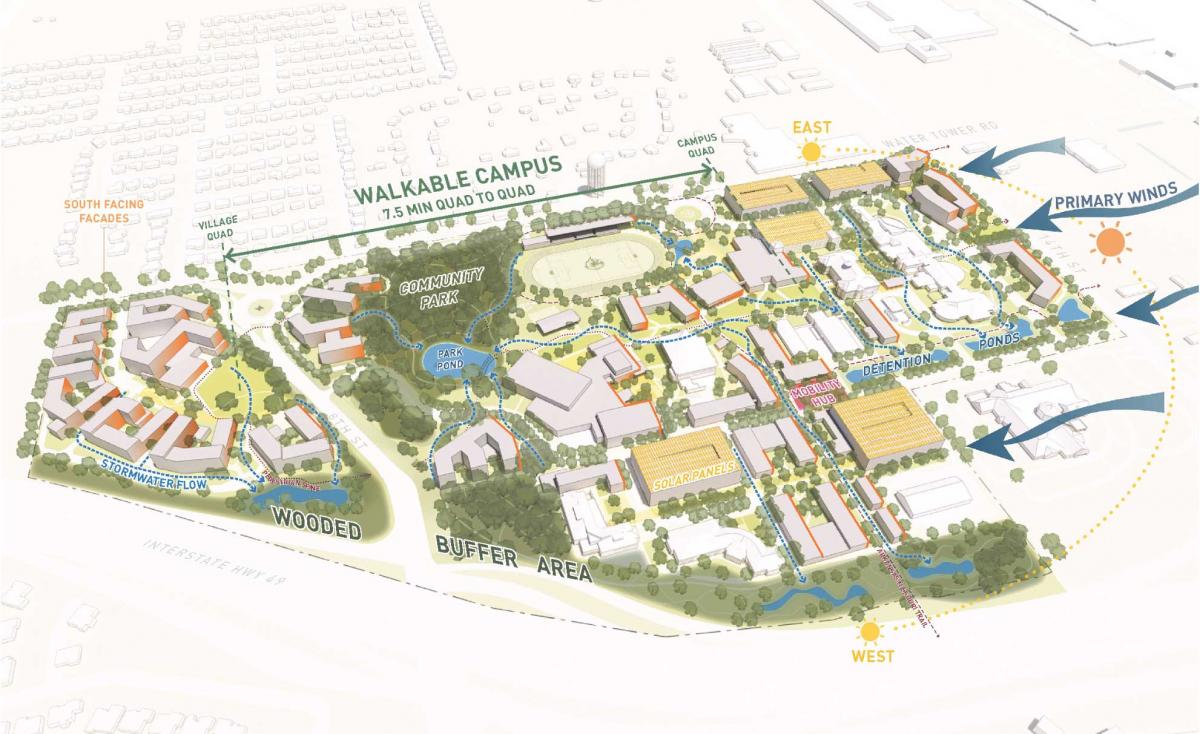
“With the ambitious goal of doubling its campus population over the next 15 years, NWACC is transforming its remaining land and underutilized parking lots into a walkable, landscape-driven academic village,” according to the design team, led by Lake Flato Architects. “The plan is organized around four pillars of growth: academic expansion, student housing, athletics and arts, and campus-wide amenities.”
Developed in collaboration with the college and the Walton Family Foundation, an institution founded by Walmart heirs (Bentonville is home to Walmart), the master plan “is the first of its kind for a community college, serving as a model for how higher education can evolve to meet both academic and civic needs,” Lake Flato says.
The campus is located midway between downtown Bentonville and Rogers, two key cities in the rapidly growing NWA metro area. Currently organized in a typical suburban layout, the goal is to transform NWACC into a 24-hour campus for living, working, learning, and playing. As such, the 130-acre plan focuses on suburban retrofit on the scale of a five-minute-walk neighborhood. Because the project is a retrofit, the plan does not call for a classic street grid—rather, it merges the few existing streets, new streets, and bike-ped trails into a network that forms the framework for urbanism.
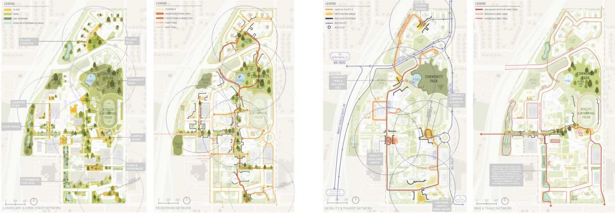
The plan would create a stronger transportation system, including a pedestrian spine running north to south through campus, and bike trails. They include the Arkansas-Missouri Trail, a former rail corridor that crosses under Interstate 49, linking the campus to a larger network of trails throughout Bentonville and the region. The bike-ped system contributes to a better block-and-street network overall.
The massive parking lots would be replaced with a series of parking structures, allowing buildings to be placed more tightly, on a walkable scale. A 10-acre community park—currently a natural area—would be developed next to a new athletic stadium. This could serve the campus and residential neighborhoods to the east. Mixed-use is planned at the southeast corner of the site, accessible to off-campus residences. A campus shuttle is envisioned to take students from a new residential village to the educational facilities.
The plan creates a new walkable district in a suburban area connected to Eighth Street, an important thoroughfare in the Bentonville street grid. The campus is a mile east of the new Walmart Home Office campus, another district that creates a mixed-use main street along Eighth Street. The thoroughfare is served by bus service connecting Bentonville to Rogers.
The 2.5 million-square-foot plan calls for 2,800 student housing beds (1.26 million square feet), plus 395 units of workforce housing and 16 affordable townhouses for faculty and staff. The mixed-use neighborhood center includes 378,000 square feet of development. A food hall, recreation and wellness center, arts complex, and more are planned.
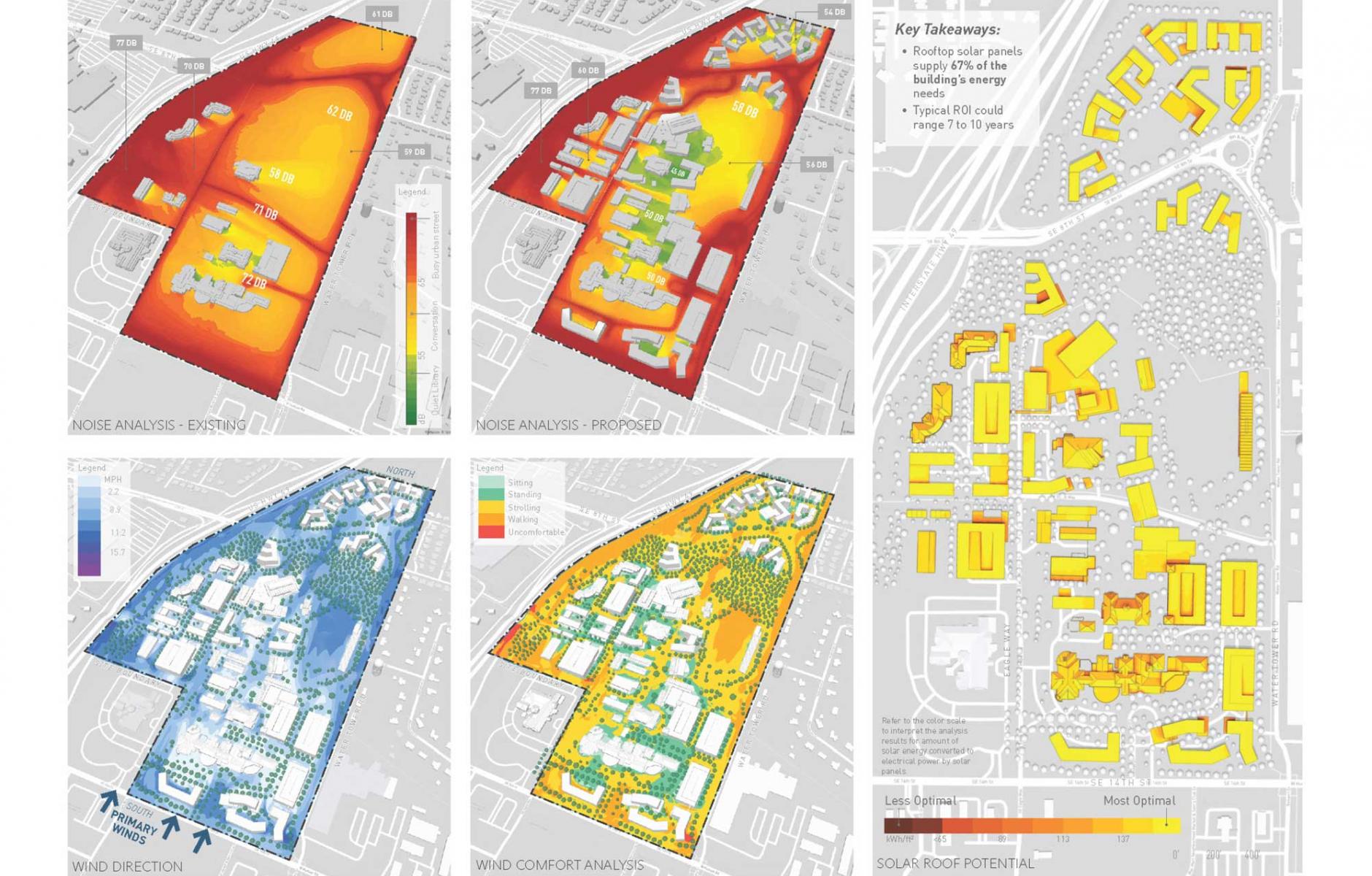
“By treating parking lots as future development sites and the Arkansas–Missouri trail as a civic spine, the project converted conventional campus liabilities into organizing elements of public life,” says Lake Flato. Two campus gathering spots, a Community Commons and Main Commons, are approximately a five-minute walk apart. The plan also pays close attention to environmental and sustainability factors, such as noise, solar, and wind levels, and alternative energy.
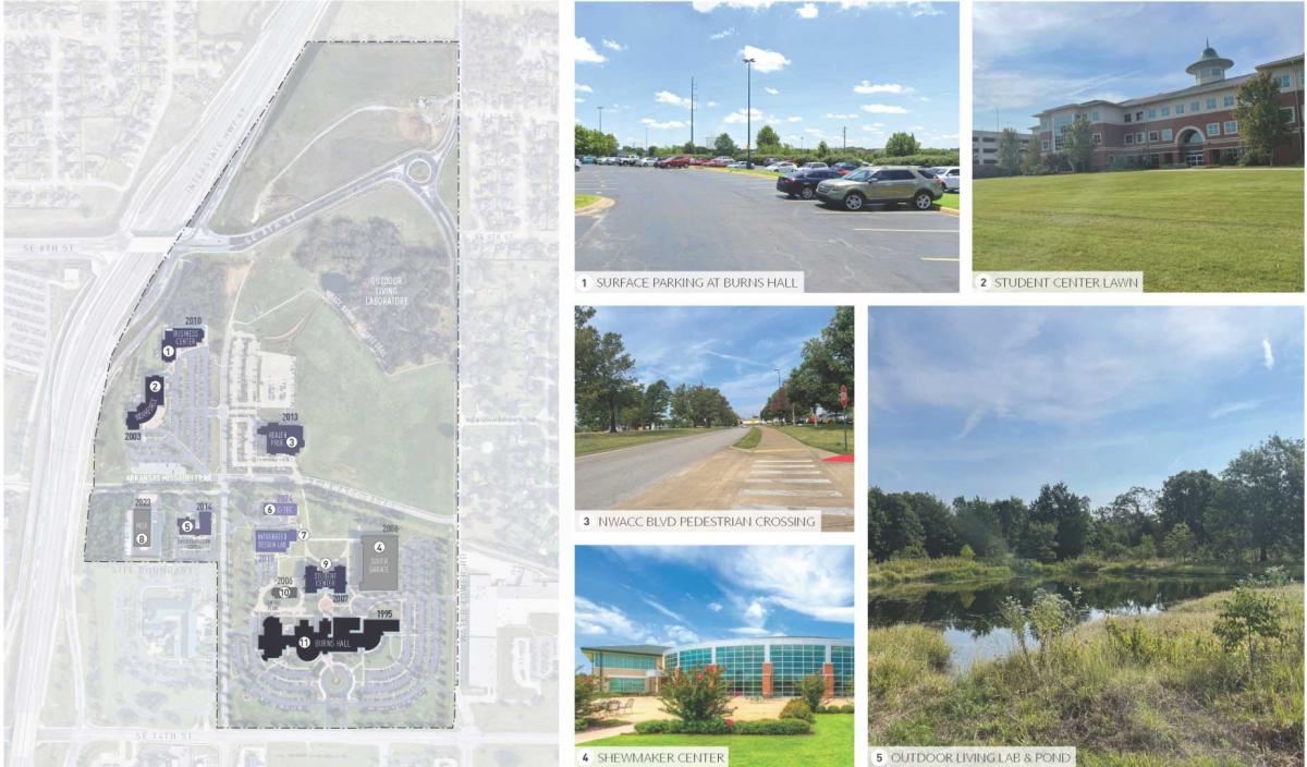
The campus today is defined by low-rise academic buildings surrounded by surface parking, lawns, and woods. The project had an immediate impact on campus growth, the team says. “Another critical lesson was the value of aligning long-range vision with near-term decision-making. Institutional planning often struggles to influence projects already in the pipeline. Through early and sustained engagement with leadership, the planning framework directly informed the siting of athletic facilities and catalyzed feasibility studies for future civic buildings, demonstrating how a master plan can guide real-time investment rather than remain aspirational.”
Note: CNU's annual Congress, CNU 34, will be held May 12-16 in Northwest Arkansas. Attendees can learn more about this and other plans.
