Watertown plans main square transformation


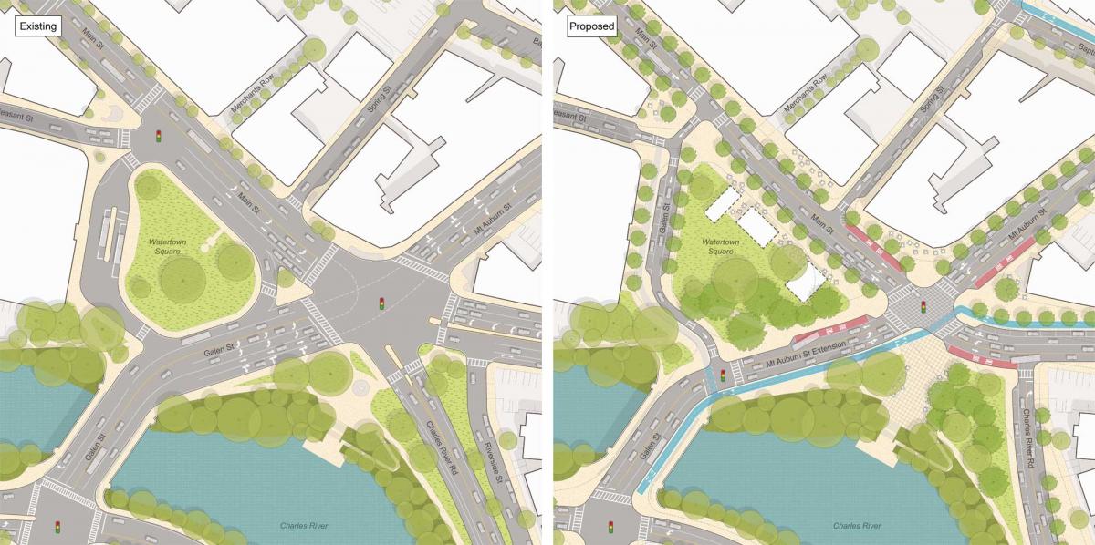
The heart of Watertown, Massachusetts, located between Boston and the car-oriented suburbs, has long been blighted by cut-through traffic. The historic public space of Watertown Square, near the Charles River, is bounded by five lanes of heavily trafficked asphalt on two sides. Consequently, the town square is not hospitable for pedestrians and a place to drive through rather than linger.
A catalyst for change came in the form of the MTBA Communities Act, a state law passed in 2021 mandating that areas around transit stations be planned for 15 units per acre, including multifamily dwellings. “According to that Act, Watertown was responsible for allowing 1,701 new housing units in its downtown to avoid losing significant State funding,” according to a design team that worked with the City. “Unlike a few more upscale local communities, like Milton and Weston, Watertown demonstrated its commitment to helping to solve a regional and national housing crisis by voting to comply.”
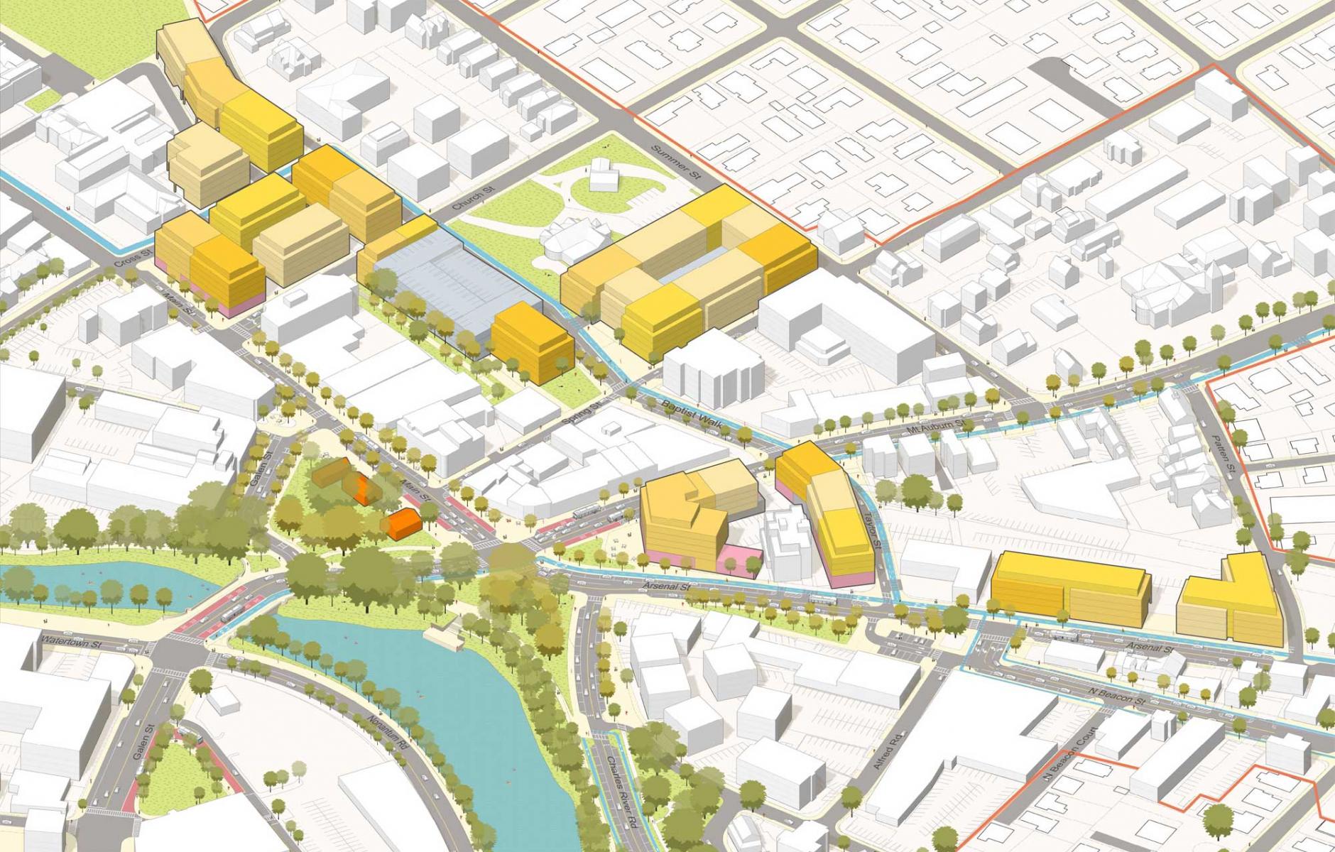
The team of Utile, Speck Dempsey, and Stantec working with the City of 35,000 people, produced a remarkable plan that exceeds housing requirements, proposes form-based zoning, and dramatically reforms the streets to make them walkable. It shows the potential of housing near transit. “Watertown responded to a request for 1,701 new housing units by allowing 4,423 units instead. We are hopeful that this outcome reflects a larger trend towards YIMBYism in the face of a national housing crisis,” the team says.
City Manager George Proakis, summarizes the plan: “When I arrived in Watertown as City Manager in 2022 there was much conversation about the need to do something about Watertown Square. Our downtown has prioritized cut-through traffic for so long, making sure to have enough space to queue up cars at the expense of our local businesses, green space and pedestrians. It was designed as a place to get through, rather than a place to be and experience our community. The Watertown Square plan will welcome both current and new residents to Watertown, will make the square a great place to live, work and play, and will turn the square into a place for people to spend time, shop, eat and enjoy all that a downtown should have to offer. The design team, through our extensive collaborative community process, engaged the largest group of stakeholders we’ve ever brought together in Watertown and created a plan that is both ambitious and achievable.”
The City Council and Planning Board endorsed the plan in July, 2024. It is heading toward implementation. “An engineering team has been hired to make it real. But it will take several years,” says planner Jeff Speck. Watertown is moving forward with zoning revisions.
The political controversy centered on the amount of housing allowed under code revisions, with some residents calling for more and others for fewer units, which was resolved with the current plan. The streetscape changes, including going from five lanes to three, with the asphalt shrunk by 50 percent, were less controversial. Given many options, the community leaned toward the solution favored by planners. The street redesign will revolutionize the area, restoring its walkability and sociability. The public space will again become the civic heart of the town.
The acceptance of the street transformation came from a growing understanding that the current traffic in Watertown Square is the result of induced demand. “Residents and business owners were told the hard but empowering truth that they would always face congestion at rush hour, but that they could decide how many lanes of it they wanted,” the team explains.
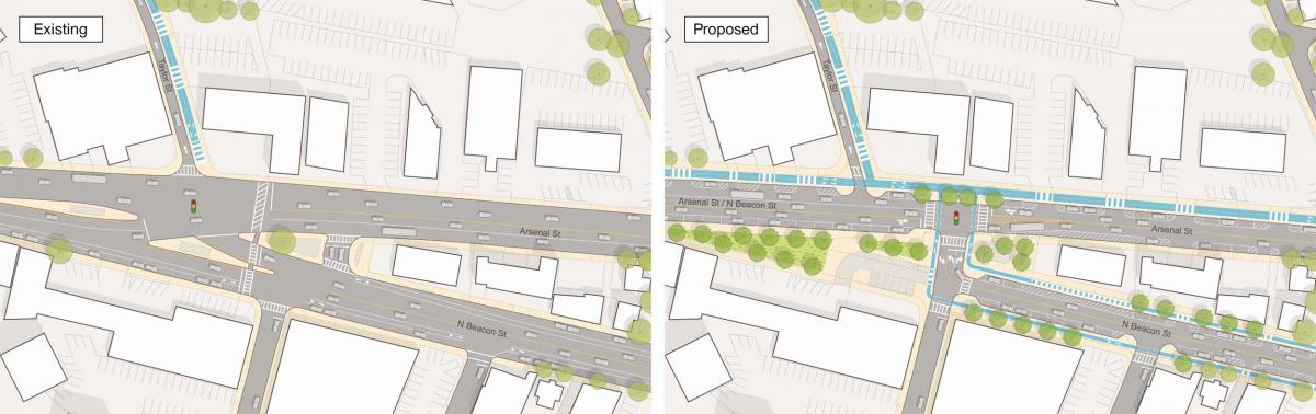
Another dramatic change was enabled by making better use of a wide bus loop on the west side of the square. This will be narrowed and used to divert traffic from the main intersection. “A dedicated bus loop flanking the square could be reversed in direction and put to use as a bypass for all vehicles,” the team explains. “Removing these trips from the heart of the square allowed for the elimination of fully half of the 24 lanes that currently enter and exit the main intersection. Traffic was dispersed further by reinstituting a street north of the square that had been blocked by a parking lot, bringing back the historical grid.” Dramatic changes are also planned for the Intersection of North Beacon and Arsenal streets.
In addition to the improvements to the square, the city’s connection to the water will be greatly improved. By making the main intersection navigable on foot, people will be able to walk to the riverfront. Net green space gained through the street restorations total nearly 150,000 square feet—more than three acres.
