Compact urbanism more resilient than sprawl


Climate change is not just a problem of carbon in the atmosphere and its impacts. It also relates to the built environment. Because, as temperatures and sea levels have risen over the last century, we have made ourselves more vulnerable by building sprawl.
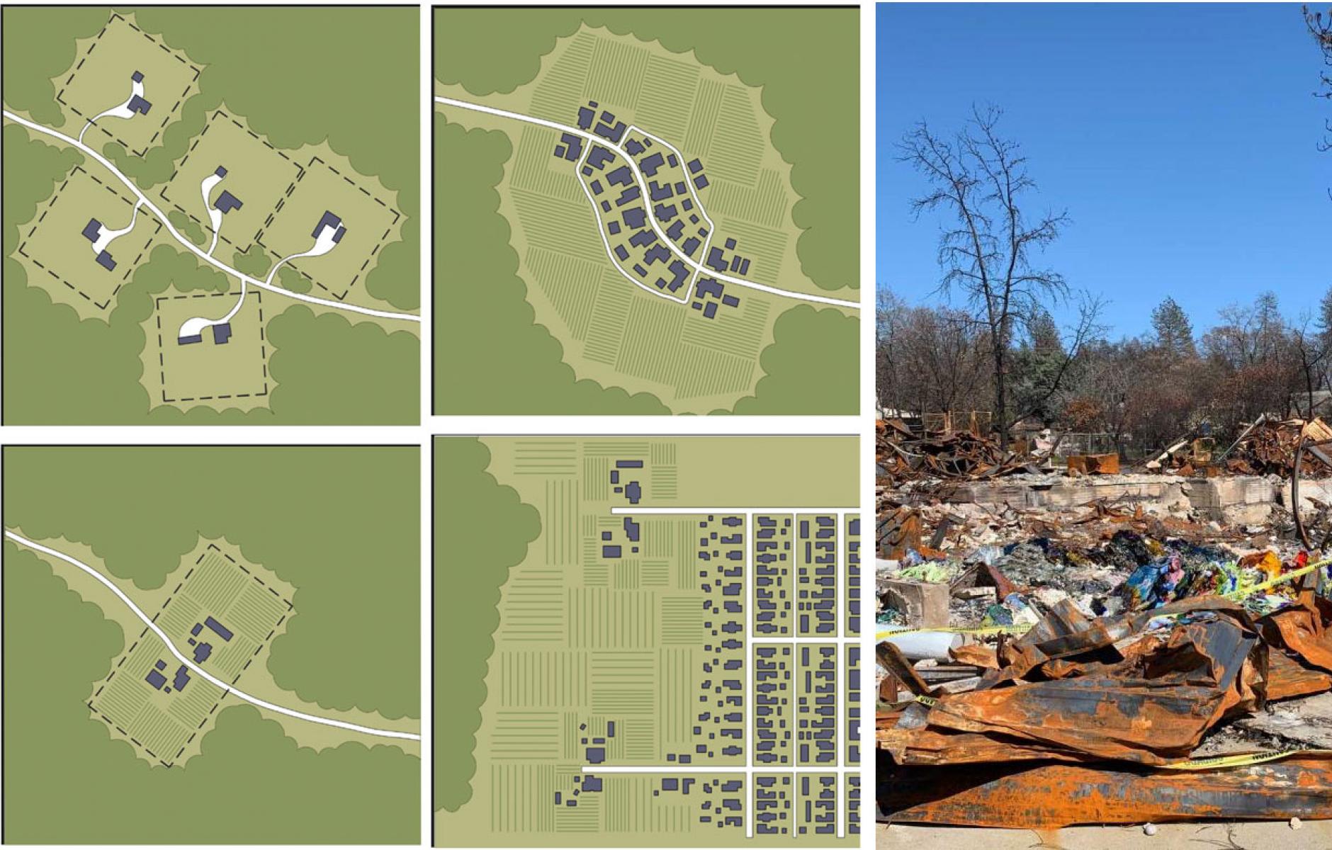
Automobile-oriented development tends to be built in areas that are especially vulnerable to climate- and weather-related disasters. These include coastlines, areas along rivers and streams, and in the fire-prone wildland-urban interface (WUI).
The SmartCode’s Fire Mitigation Module, a land-use code designed to be applied in fire-prone areas, prohibits “dispersed development that requires numerous and redundant Zones of Defense and increases the extent of WUI.” More compact development does the reverse, shrinking the fire Zones of Defense that are needed. The module was written by Martin Dreiling, a California-based architect and expert in making communities more resilient to fire. Sprawl is a well-known problem for wildfire management risk.
We can see the impact in the Palisades and Eaton fires of 2025, which killed 31 people and destroyed more than 16,000 buildings, and the Camp Fire that destroyed most of Paradise, California, in 2018, claiming 86 lives. These urban areas encroach well into the WUI. Paradise is a suburban community of residential roads that wind up into the high-fire hazard foothills of the Sierra Nevada.
In the pre-automotive era, California was developed in compact cities and towns. Forest and brush fires burned largely outside of towns, on hillsides. As California sprawled in the 20th Century, many of those hilly areas were developed in ways that vastly increased the WUI, making defense against fires more difficult. Sprawl is defined as largely single-use, low-density, automobile-oriented development patterns.
Similarly, look at another highly vulnerable area, Southeast Florida. In 1950, the coast included a series of distinct cities, most of them small. Miami had 249,000, West Palm Beach had 43,000, Fort Lauderdale had 36,000, and Hollywood and Lake Worth Beach were towns with a little over 10,000 residents. In between were miles of countryside and mangrove swamps. If a storm came ashore, the chances were good that the most destructive part would land in a little-populated area. Today, you can travel 115 miles from one end of the metro region to the other, and see sprawl nearly all the way in a narrow, low-lying band. That is not just due to growth, but also to low-density suburban patterns that occupy a large amount of land and hold a significant population. If a hurricane hits today in Southeast Florida, the chances are nearly 100 percent that the most destructive part will impact a lot of people.
Or take Hurricane Helene in North Carolina, which took 108 lives and damaged or destroyed upwards of 100,000 homes. Most of those homes were along rivers like the Swannanoa, which flows down from the mountains through Asheville. Architect Steve Mouzon, who worked on relief planning, notes that most of the houses along the river outside of historic settlements were mostly post-1950 construction. “People build houses on the river for similar reasons that they build on the coast,” Mouzon says. “It is beautiful.” This is not classic sprawl, but it is a form of sprawl. In response to that growth, infrastructure was built, like roads, bridges, and culverts that were severely damaged in the storm.
In the mid-20th Century, fewer houses were located on the water, both inland and on the coast. Fewer people traveled, less often, for vacation. Fewer people owned second homes at the beach or in the mountains. In the intervening years, the year-round populations in many areas near water have skyrocketed.
Urbanist Michael Mehaffy describes the overall effect as creating a bigger target. “Sprawl is already a well-known problem for wildfire risk management—not only going into riskier wooded areas, but creating a bigger target,” says Mehaffy. “The same logic applies to storms and other natural threats—sprawl creates a bigger target.”
At the same time, sprawl features poorly connected street networks, which impact access and evacuation. A goal in Paradise’s recovery plan from the Camp Fire is to build a more connected street network, because most fatalities occurred on long, dead-end roads. Connected street networks have multiple health and safety benefits.
As communities plan for climate change, we can’t forget the impact of sprawl. The reverse of sprawl is compact, walkable communities. These respond better to climate change for many reasons. They reduce carbon emissions per person, because of less need for driving, which substantially cuts household fossil fuel use. But they also reduce vulnerability to climate change. Compact communities can more readily be defended and made safe.
In short, we need to stop making ourselves more vulnerable to climate change through poor decisions in planning and building towns and cities. That would be a key step toward a more resilient society.
