How Cincinnati’s riverfront was transformed


Note: CNU 32 will take place in Cincinnati May 15-18, where visitors will see many examples of New Urbanism and urban revitalization throughout the city and across the region.
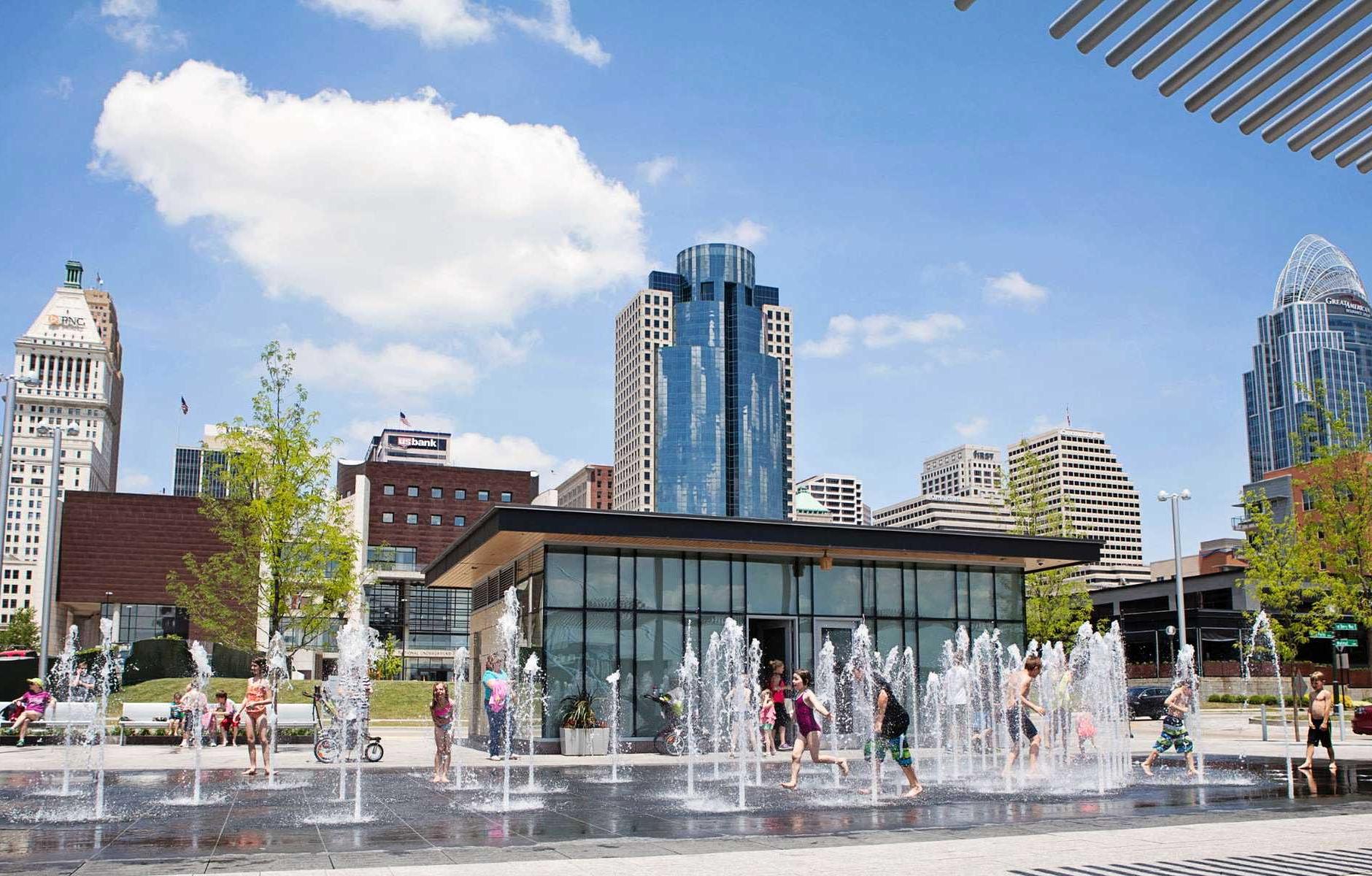
The Banks Neighborhood was built on an underutilized area with stadium parking between Interstate 71 and the Ohio River in downtown Cincinnati. The mixed-use development connects downtown to the river and the historic John A. Roebling Suspension Bridge, which carries multimodal traffic to Covington, Kentucky.
The Banks sits between 21st-Century professional sports stadiums and is anchored by the National Underground Railroad Freedom Center, a museum honoring the network of routes and safe houses, of which the Queen City was a hub, for African Americans escaping slavery.
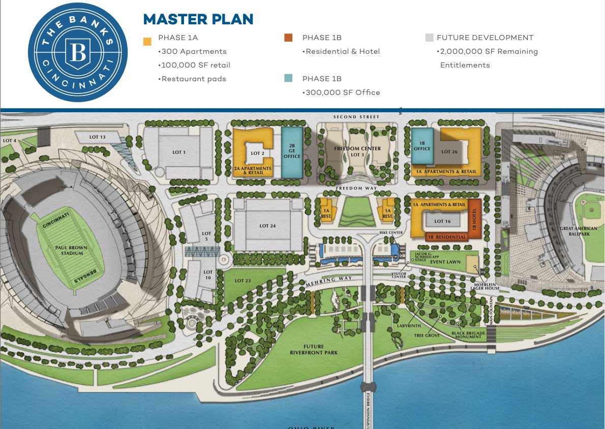
The neighborhood includes parks, concert venues, living spaces, and commercial uses, and it grew out of a transformative 1996 Riverfront Master Plan. Roxanne Qualls, mayor in the 1990s and again from 2007-2013—and a CNU board member from 2000-2008—spearheaded the project, planned by Urban Design Associates (UDA). If not for Qualls, the development might have been more conventional. “She was determined to make it about more than just the stadiums,” explains Ray Gindroz, UDA co-founder and principal emeritus.
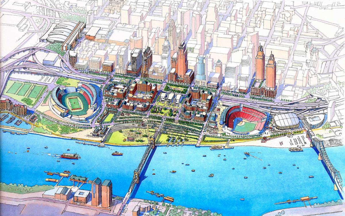
The plan was driven by replacing the outdated stadium with two modern venues designed for baseball and football. Also, the mile-long section of I-71 was deteriorating and needed to be replaced. The economic strength of two sports teams and the US DOT powered the project, starting with the stadiums (Paycor and the Great American Ball Park) that opened in the early 2000s. “This was a rare, fortunate circumstance involving two professional sports teams and a federal highway,” notes Gindroz. Cincinnati sought to leverage the stadiums to build attractions, development, and parks as part of a mixed-use district.
Built over the last 15 years, The Banks is a remarkable transformation of a formerly barren area. For urbanists coming to CNU 32 in mid-May, it’s a must-see urban development within a short walk of the downtown venue.
In the mid-1990s, the Cincinnati riverfront was a very different place. Much of it was taken up by the massive, multi-use Riverfront Stadium, home to the Reds and the Bengals. The rest of the area was surface parking and utilitarian buildings. The stunning Roebling bridge, the prototype for the Brooklyn Bridge, was accessed by a viaduct that carried automobile traffic over the sterile landscape.
“Our planning process was essentially the same as the process we used to plan urban neighborhoods,” says Paul Ostergaard, who managed the project for UDA. “At the time we were working on Hope VI neighborhoods in Baltimore, Norfolk, Portsmouth, and Louisville.” A steering committee of County commissioners, city councilmen, the mayor, and other government leaders guided the process, with extensive involvement of residents and stakeholders. The plan emerged from key principles and ideas, Ostergaard explains:
- Streets: Re-establish the city grid to the river.
- Parks and open space: Transform existing isolated parks into a riverfront park system.
- Overcoming highway barriers: Seize the opportunity to remove Fort Washington Way (I-71 between downtown and the river) as a barrier to the riverfront.
- Parking: Create centrally-located, multipurpose parking
- Economic development sites: Preserve sites that are linked to downtown, the stadiums, and parking for economic development.
- Attractions: Link attractions to the downtown retail and office core
- Public transportation: Construct a light rail or parking shuttle to link neighborhoods and parking with downtown Cincinnati and Kentucky.
- Scale of development: Preserve the view from downtown to the river and from the river to downtown
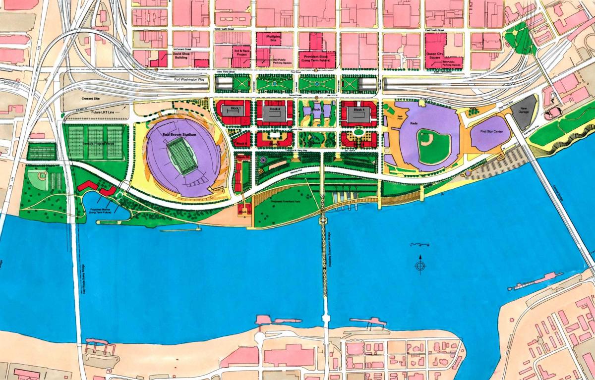
“We presented these principles as part of our planning work and they were adopted by the city and citizens,” he explains. At the same time, the engineering firm Parson Brinckerhoff generated multiple options for rebuilding Fort Washington Way. “This master plan process made it abundantly clear that the total reconstruction option was the best choice (and most expensive) and gave them a clear path forward to design and build it. The master plan envisioned decking over the Interstate … in several locations to minimize the noise. This was not achievable at the time, but foundations were built to accept these lids in the future.”
Meanwhile, the waterfront was subject to frequent flooding, so it was largely surface parking. “This master plan essentially built a whole district two stories in the air with two parking levels and a transit terminal under street level,” Ostergaard explains. “All development in the district, including buildings and streets, is over parking.”
During the master planning process, UDA collaborated with the city and many designers for the stadiums and the museum. The team also created design guidelines for the mixed-use blocks, providing the city with a solid framework plan to adapt to the changing market. For example, the mixed-use development did not begin until after the 2008 housing crash. “Much of the plan is built as originally planned, and new ideas have been incorporated as well,” he explains.
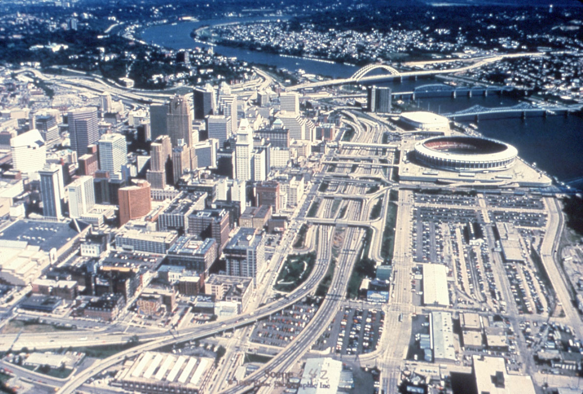
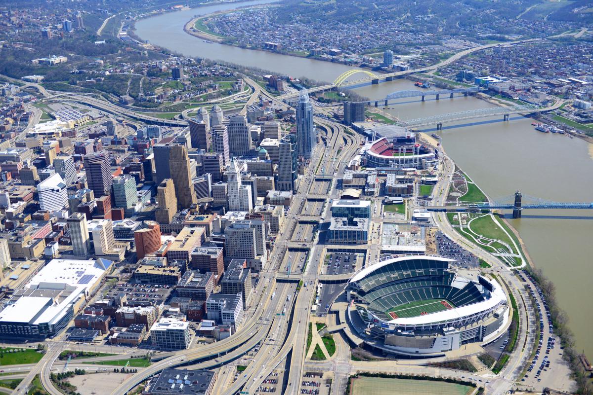
The five new and rebuilt bridges carrying downtown streets over the Interstate improve pedestrian access to the waterfront area. As can be seen in the before-and-after aerial photos, the width of the highway infrastructure was greatly reduced relative to downtown and The Banks. The city’s streetcar, which began operations in 2016, goes to The Banks, although not through it. The historic Roebling Suspension Bridge now lands on a roundabout instead of a viaduct and can be accessed by pedestrians and bicyclists in addition to cars.
Three blocks near the football stadium remain to be developed, so construction of The Banks is planned to continue for many years to come. Although The Banks is unfinished, and some of the principles have yet to be fully realized (such as overcoming the highway barrier with caps), the development has largely met its ambitious goals.
“I think the Cincinnati waterfront is a great story because so many citizens and design firms were involved in its creation,” concludes Ostergaard.