Why your city needs a downtown ‘walkability plan’


A rose by any other name would smell as sweet: Complete streets plan? Vision zero plan? Active mobility plan? Micro-mobility plan? Walkability study? I’ve called them “walkability studies” since 2009, when we did our first, in Oklahoma City. Now I call them “walkability plans,” because “study” does not suggest how these efforts produce street designs that can be implemented immediately—and often are.
Over 30 years, I’ve watched as my desire to do impactful work turned me from a would-be-architect into an urban designer into a city planner into a streets guy. I still enjoy designing buildings, public spaces, and neighborhoods, but what I seem to do most these days is pace city streets, because that’s where the real need is. Six years of postgraduate design school, and my most valuable skill is a dependably accurate 3-foot stride.
As related in Walkable City, people will choose to walk when walking is useful, safe, comfortable and interesting. Three of those qualities—useful, comfortable, and interesting—are principally a function of long-term planning. Proper zoning codes, incentives, and hand-holding can help a city achieve the mixed-use fabric of friendly-faced buildings that give people a reason to walk and keep walking. But these things take time, one political cycle at least. Meanwhile, a city can achieve much greater safety in just a year or two, before the next election, by fixing its streets.
And the mandate could not be greater because, if you haven’t been paying attention, it’s a bloodbath out there. Pedestrian deaths have risen 82 percent since 2009. Norm Garrick notes how, in 1970, a pedestrian was twice as likely to be killed in a crash in the US than in the Netherlands; today the ratio is 20 to 1.
This is no accident; it’s by design. Strong Towns founder Chuck Marohn is one of a growing number of red-pilled engineers who have taught us how American street design is simply broken. The typical US street has been built to invite speeds well above the posted limit; I wrote about it in The Hill. Long-time CNUer Wes Marshall is the latest contributor to this important conversation. His new book, Killed by a Traffic Engineer, documents plainly how hard it will be to fix a wayward profession. But it’s easy to fix our streets, and more cities do it every day.
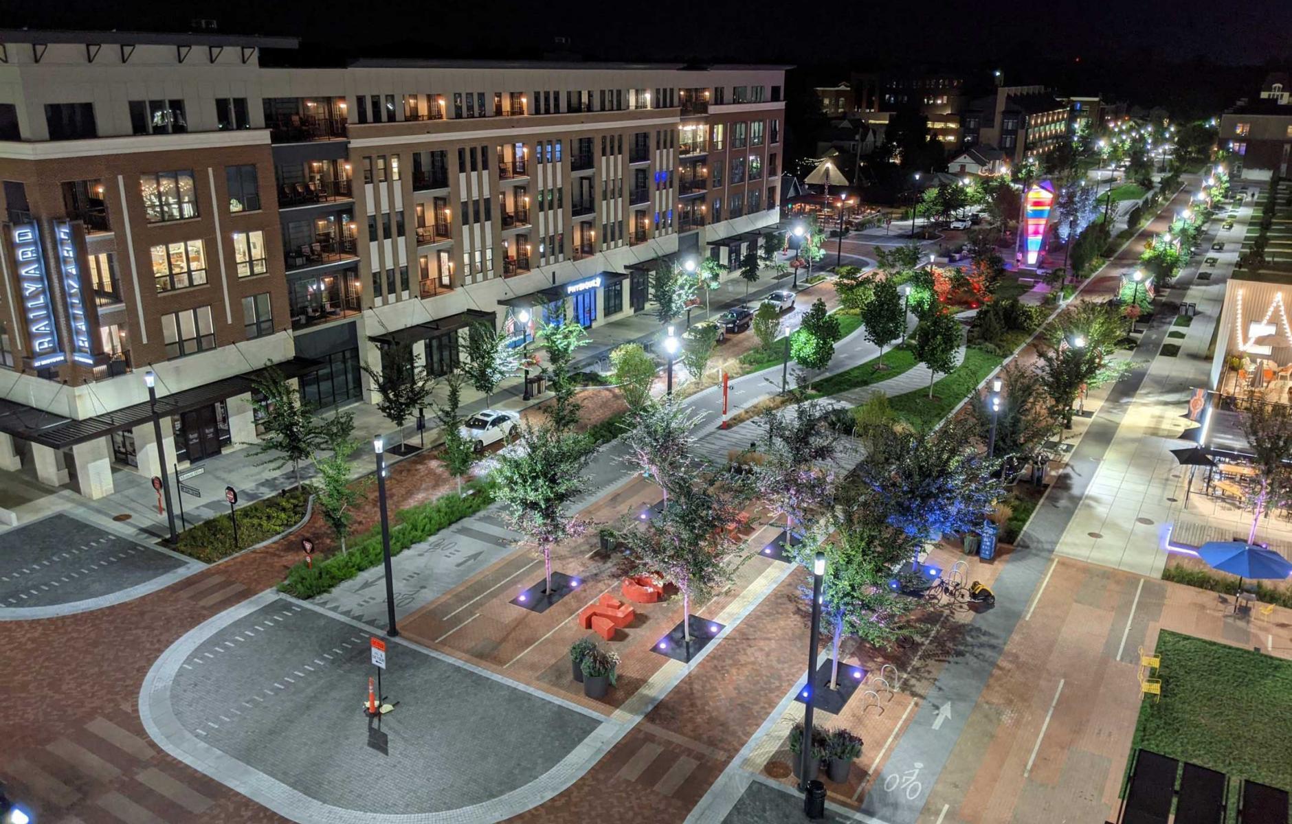
What does a proper downtown walkability plan look like? We do most of the work in one week. Every morning is spent in meetings with constituents and city staff. Every afternoon is spent walking the streets and redesigning each one. Almost every street needs changes, and most can be accomplished cheaply, with paint. The objectives are simple: making walking and biking (and driving) safer, and helping businesses to thrive. The strategy is straightforward: redesign streets to discourage illegal speeding. The tactics are many, and typically include the following:
1. Remove excess lanes. Almost every downtown, even congested ones, has streets with more lanes than traffic demands. In Oklahoma City, we were able to remove fully a third of all lanes downtown, which allowed a doubling of on-street parking capacity and the creation of a bike network.
2. Road-diet 4-laners. Any two-way street that is currently four lanes wide can be re-striped to three lanes—gaining space for bike lanes or parking—with great safety improvements and little to no reduction in capacity. Four-lane streets, where the passing lane is also the turning lane, are as inefficient as they are dangerous. A study of 22 four-laners dieted to three lanes showed that, on average, vehicle through-put was maintained at or above prior levels.
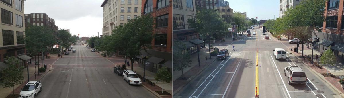
3. Right-size the lanes. Many downtown streets have lanes 12 feet wide or wider, a highway standard inviting high speeds. The NACTO standard for a busy urban lane width is 10 feet, or maximum 11 feet on major busways. Any extra foot of asphalt in any lane is an investment only in speeding, and should be rededicated to other uses. In Newaygo, Michigan, the State DOT reluctantly allowed us to turn a high-speed parked-one-side Main Street into a lower-speed parked-both-sides Main Street by right-sizing 13-foot-wide lanes.
4. Redirect reclaimed street space to best-practice bike lanes. The three strategies above allow valuable asphalt to be rededicated to more productive use. Sometimes that use is parking, but just as often it can be a cycle track, a pair of bike lanes, or a single bike lane with its partner placed on a parallel street. When streets are rebuilt, bike lanes should be located up on the sidewalk edge, Copenhagen-style. When simply re-striped, bike lanes are best protected by a row of parking or placed along an unparked curb. Like many firms, we were willing to stripe door-zone bike lanes a decade ago, but no longer engage in that practice.
5. Revert multilane one-ways back to two-way. Hundreds of American downtowns were devastated by the conversion of their streets into one-way pairs between 1950 and 1980 in the mistaken belief that it would end traffic congestion. Many dozens have revived their economies—and saved lives—by correcting this error. Our plan for New Albany, Indiana, reverted an almost entirely one-way street network back to two-way travel. The police chief was initially reluctant to make the change. Afterwards he told a CNU audience that he had “never seen a better scenario for public safety.”
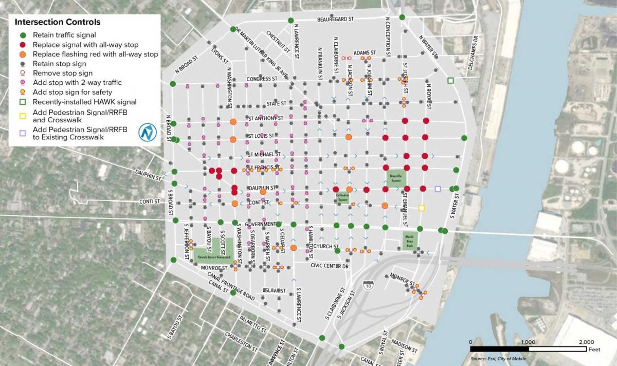
6. Replace signals with all-way stop signs. A study of 199 signals converted to all-way stops in Philadelphia found that severe pedestrian injury crashes dropped by 68 percent as a result. Our walkability plan for downtown Albuquerque caused the temporary removal (bagging) of seven signals. These were brought back after driver complaints, but then removed permanently after drivers realized that the stop signs had shortened their trip times. Driving more slowly and stopping more frequently, they were getting through downtown more quickly due to never having to sit at a red light. Cities that value life and property should retain no signal on any intersection where an all-way stop will suffice.
7. Tighten oversized intersections. Swooping intersections, forks, and slip lanes should be eliminated in favor of tighter geometries and curb radii that are no larger than those required by the largest vehicle that uses the street frequently. Whenever confronted with swooping, “streamform” geometries, drivers speed up. Our plan for Boston’s Kenmore Square transforms a vast fork into a simple right-angle intersection with curb extensions that surround parking lanes to minimize crossing distances.
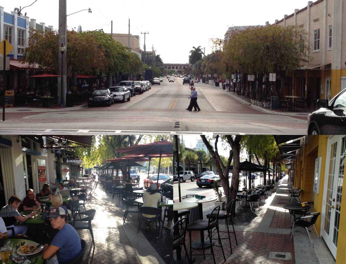
8. Protect curbs with parallel parking and trees. Nobody walks happily on a sidewalk directly against traffic. Parallel parking is a powerful barrier of steel that protects pedestrians from moving vehicles; few retail streets survive without it. Street trees, essential for so many reasons—CO2 and stormwater absorption, heat island reduction, wildlife protection, and crime reduction—provide another important layer of defense. Studies have shown that, far from increasing car crashes, street trees actually make streets safer overall.
9. Stripe parking but not centerlines. White lines or stall markings against parking lanes visually restrict the driving zone and can be expected to reduce speeding. In contrast, yellow centerlines give drivers comfort and have the opposite effect. Studies have shown that, when a centerline is removed from a street, drivers become more wary of approaching traffic and drive an average of 7 mph slower.
10. Follow the data. Most cities now know where most people are walking, biking, and being injured and killed. Safety improvements should be directed first where they can have the most impact.
Not every city can act upon all 10 of the tactics listed above, but most can accomplish most of them. In 15 walkability plans completed over the same number of years, we’ve seen how making city streets safe for walking and biking can be the essential step in bringing a downtown back to life. My only surprise in doing this work has been that more cities were not asking for it. Now, with growing interest in downtown walkability but worsening statistics on pedestrian safety, that picture has begun to change. And a few billion in federal funds doesn’t hurt.
The techniques above are not proprietary; you’re welcome to them. In fact, we implore you to use them. The challenge is not knowing what to do, but being allowed to do it—by your engineering department, by your fire and police chiefs, and by your constituents. That’s where experience counts, and why we are ramping up.