Learning from the planners of old


A meme posted by a New Urbanist touches upon an important truth about how we build communities today, and why it is so difficult to create good places.
New Urbanists are very good at designing great urban places—not as good, so far, at getting them built at the scale that is necessary to meet demand and make walkable places affordable.
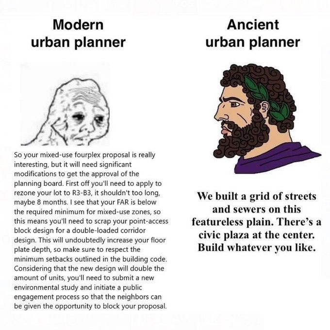
The meme, posted by Southern Urbanism writer Aaron Lubeck, compares a conventional, modern urban planner to an ancient planner. The modern planner presents a familiar litany of obstacles to the builder trying to create housing in an urban place (“you are going to need a rezoning … the FAR is below the required minimum for mixed-use zones … you will need to scrap your point access block design for a double-loaded corridor design,” etc.). The demands sound depressing and discouraging, if not a bit ridiculous—but they are grounded in today's entitlement environment.
In contrast, the ancient planner lays out a street grid with a public space in the middle and says, “Build whatever you like.” The ancient planner is portrayed as a Roman, but this is essentially how cities were built around the world until recently. (Yes, there were sometimes additional requirements, but these were minor relative to modern zoning. The Law of the Indies, for example, required a street grid with a church on a plaza and street orientation in cardinal directions to capture prevailing winds.)
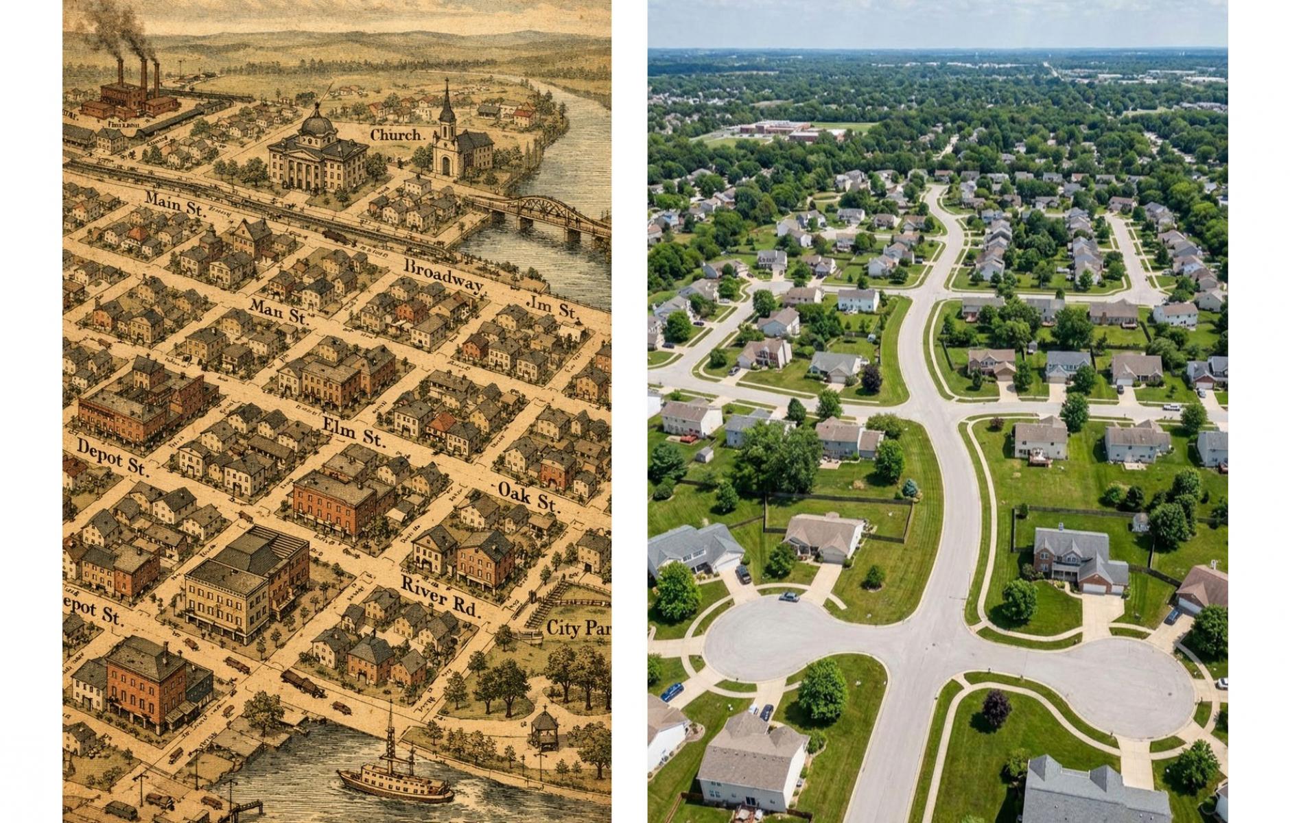
This was essentially the approach in America through the first quarter of the 20th Century. Even after zoning was enacted in many cities in the 1920s, we still extended street grids for a couple of decades, and it was relatively easy to build a wide range of housing (street grids allowed incremental development, and zoning was simpler then). That began to change when we suddenly stopped putting down street grids circa 1950 and instead relied on private developers to build curvy cul-de-sacs. Those became progressively less connected over the course of the 20th Century.
The new system required subdivisions to be approved that connected to arterial roads. Each subdivision specialized in a particular type of housing. They loaded traffic onto arterial roads, creating the need to widen them, at which point everybody had to drive, so minimum off-street parking requirements were established. We found ourselves in a vicious circle of planning and land use.
We have been combating all of this by changing zoning and land-use regulations. That’s important work that continues today, and we have a long way to go in zoning reform to allow more affordable, diverse communities to be built.
New Urbanists are prolifically writing form-based codes (FBCs), and those regulations are being widely adopted. Ideally, these improve the planning system and alleviate many issues the modern planner presents in the meme. And yet, I believe we are missing a vital step relating to process.
The best historical places were not built with FBCs. They were built in a more direct way, starting with a street grid, as the meme suggests. Urbanists may argue that the grid is embedded in the code, and that is true. FBCs include provisions such as maximum block sizes or minimum intersections per unit of land, which, if followed, will result in a connected street network. And yet I don’t think the founders of historic towns across the US thought about regulating block sizes or intersections. They just put down a street grid, and if a block was too large, they cut a street through it.
I was recently told that during the Oklahoma land rush, blocks and streets in Oklahoma City were surveyed during the first 24 hours, through the night, and construction began almost immediately. Those blocks are now part of the city center.
Modern planning is a complicated process that involves architects, code enforcers, developers, engineers, planners, and public policy. Yet it could be a lot simpler, as the meme suggests, and a key to that simplification is a more direct approach to building well-connected street networks, which are essential for walkable urbanism. Abstract concepts won't get these networks built, at least not at the scale and timeliness we need. Instead, we need to retrace how the best parts of cities and towns were actually built. If the 19th-Century city founders could do it in a night, shouldn’t planners with master’s degrees, aided by consultants, be able to do it in a reasonable amount of time?
As we reform zoning laws, let’s also learn from historical planners by directly and efficiently establishing street networks. The process reminds me of the old Nike commercial, “Just Do It.” That would take us a long way toward making good places easier to build.
