Project aims to connect a city


Norwood is a small city of neighborhoods. An enclave surrounded by Cincinnati, Norwood has a “porch culture.” Residents hang out on their porches and greet their neighbors. However, traveling from porch to porch may be challenging, as the historically working-class city has four wards. Each ward is urban and densely populated but divided by 20th-century roadways crossing the city.
Many of Norwood’s former industrial jobs are gone. Still, the city could reinvent itself by connecting to new amenities—like the 34-mile CROWN (Cincinnati Riding or Walking Network) of multipurpose trails, which is currently being developed to link the region as a whole. The city of Norwood and the nonprofit Norwood Together asked CNU to co-sponsor a Legacy Project to boost health, quality of life, and the local economy. Stantec’s Urban Places led the citywide connectivity project for CNU. Legacy Projects leverage CNU’s planning and design expertise to impact the annual Congress’s host region long-term—CNU 32 will take place May 15-18 in Cincinnati.
“It’s an incredible opportunity to be involved in this project,” Mayor Victor Schneider told CNU. “The community needs this as we move forward with transportation improvements.” The project generated a list of 30 improvements that the city could undertake in four categories: corridors, intersections, crossings, and gateways. All would enhance connectivity in the city and to the region.
The challenge
Norwood is sometimes considered a suburb of the Queen City, but it is quite urban. At 6,000 people per square mile, it is 50 percent denser than Cincinnati (about 4,000 people per square mile).
Norwood includes multiple neighborhoods, districts, corridors, and a small downtown. The challenge is to connect these and link them to the larger Cincinnati region. Norwood has good bones, but it has also faced many decades of automobile-oriented planning that undermines connectivity and negatively influences travel behavior. Montgomery Avenue, the city’s primary north-south arterial, divides wards to the west and east. The Norwood Lateral, an east-west limited-access highway, divides the northern and southern wards. A rail line, another infrastructure barrier, runs closely parallel to the Lateral.
Like Cincinnati as a whole, Norwood suffered from the loss of industrial jobs. The city lost a General Motors assembly plant in the 1980s that built muscle cars—Caramos and Firebirds. Today, increasingly scarce talent is heading toward mixed-use, walkable places, and jobs and investment are following, according to Stantec’s Urban Places. The Wasson Way trail, part of the CROWN, is at the south end of the city. The Wasson Way is an attractive amenity for those who want to live in Norwood if residents can easily reach it. Xavier University is adjacent to the city, contributing to a market for walkability.
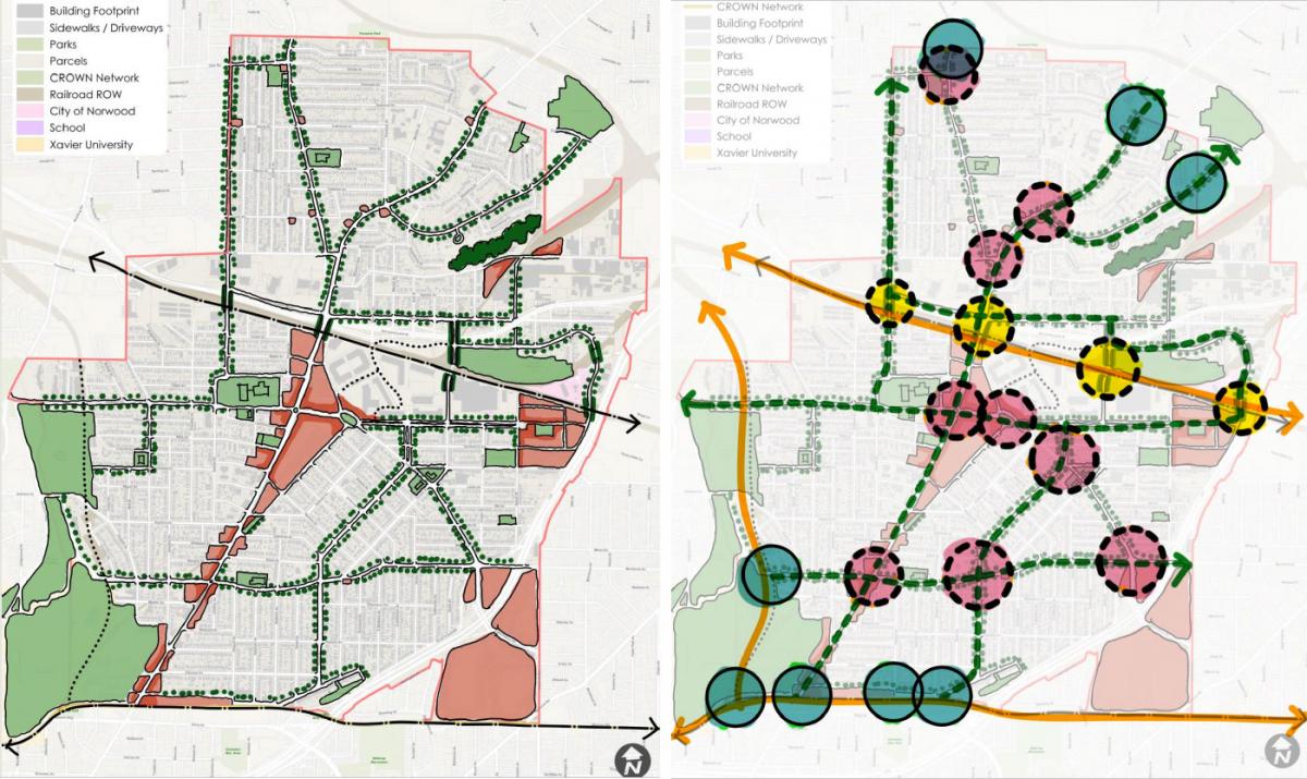
The project aims to connect 1) neighbors, 2) neighborhoods, and 3) Norwood to the larger region. Over three days, with the help of about 150 participants from the city, the team presented a conceptual plan focused on four kinds of connectivity projects.
Corridors
Seven multimodal corridors will allow residents to traverse the city more easily—on foot, bicycle, e-bike, motor vehicle, and transit. The corridors, shown on the illustrative plan as tree-lined thoroughfares, link with schools, parks, and the CROWN, allowing residents to reach many parts of the region on bikes. They also enable mobility to mixed-use areas and employment within Norwood, and connect multiple wards together. These corridors are currently hampered by automobile-centric planning decisions of the 20th Century, but they are built on a well-connected block and street network. A road diet was suggested for Montgomery Avenue to reapportion the existing pavement for more modes of travel.
Intersections
Montgomery Avenue is a commercial arterial that is intimidating to cross on foot. By improving the geometry and pedestrian amenities of intersections, wards to the east and west could be better connected. Besides those on Montgomery, several other city intersections could be more accommodating to pedestrians and bicyclists. The planning team identified nine intersections of particular importance, many of which link multiple corridors at key junctures. Safe intersection crossings are critical to improving the entire network of corridors and trails.
Crossings
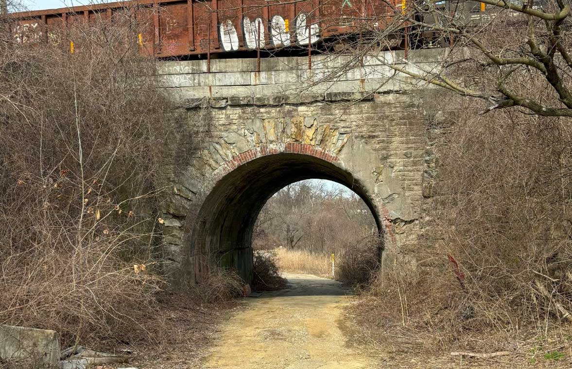
The Lateral and railway can only be crossed by going over or under, and opportunities to do that are limited. The team examined three crossings—and envisioned a fourth. The latter is an underused tunnel beneath the tracks that would connect Factory 52, a major development on the City’s east side, with the Waterworks Complex park. The four crossings are intended to provide safer crossing opportunities and will better connect the city, especially along multimodal corridors.
Gateways
Eight gateways are located at Norwood’s south and north borders. Five in the city’s southeast connect neighborhoods to the Wasson Way and the CROWN, allowing Norwood residents to bike all over Cincinnati. Three at the north are located on multimodal corridors identified by the planning team.
A dozen projects were identified as “quick wins” (significant impact, lower cost, immediately achievable), including three corridors, three intersections, two crossings, and four gateways. Another 10 were categorized as intermediate projects with a longer time horizon for coordination. The remainder were called long-term strategies, with higher costs and an aspirational quality.
Many of the city’s elected officials attended the events, which should help implementation. Without the Legacy Project and funding from Duke Energy covering Norwood’s contribution, the city would not have been able to afford this planning effort, Schneider explains.
“The plan was very well done,” says Mary Miller of Norwood Together about the planning team. “We are an older community, and figuring out how to make it bikable is challenging. They brought new ideas to a small town and didn’t have a bias. They looked for opportunities to make it work.”
The Legacy Project team will present a full report to Norwood. Other CNU Legacy Projects in 2024 are taking place in the Cincinnati neighborhood of Camp Washington, the City of Xenia, and Amelia, an unincorporated village in Pierce and Batavia townships. Public Square will soon be reporting on these projects.
