Amenities or infrastructure? Who gets to decide?


The Charter of the New Urbanism begins with a premise that infrastructure accounting still struggles to absorb. It treats disinvestment, placeless sprawl, separation by race and income, environmental deterioration, loss of agricultural lands and wilderness, and erosion of built heritage as one "interrelated community-building challenge." It then makes a second claim: economic vitality, community stability, and environmental health cannot be sustained without a coherent physical framework. The Charter's 2024 amendments sharpen the point. They connect transportation policy to economic, environmental, health, and equity benefits; identify urban resilience and localized self-sufficiency as essential to adaptation; and affirm the public's right to participate in decisions that affect them.1
That proposition is easy to endorse and harder to budget. A street tree can provide shade, intercept stormwater, support habitat, improve pedestrian comfort, and contribute to economic development. A restored creek can improve water quality while managing floods, creating habitat, opening public access, and supporting recreation. A living shoreline can protect critical facilities and private property while rebuilding coastal habitat and supporting fisheries, tourism, and specialized local work. The physical systems overlap; the institutional systems that pay for them usually do not.
Calling something an amenity, then, is rarely a neutral description. It is an accounting decision. The label helps determine which department pays, which benefits count, which time horizon matters, and what gets removed when a project is value-engineered. The harder question is not whether a porch, tree, greenway, wetland, or shaded sidewalk is pleasant. It is who decides which of its functions are serious enough to count as infrastructure.
What the ledger can see
The challenge is easiest to see at the neighborhood scale. Transportation, parks, public health, stormwater, economic development, emergency management, and environmental programs tend to operate through separate budgets and professional vocabularies. Residents experience one place. The spreadsheet sees separate cost centers. A project that generates small but meaningful returns across five systems can therefore look weaker on paper than a single-purpose project whose benefit sits neatly inside one agency’s ledger.
James C. Scott's Seeing Like a State offers a useful explanation for why this persists. Institutions make complex reality legible by narrowing attention to what can be standardized, measured, aggregated, and managed. The simplification is often necessary; it is also selective. Scott's example of scientific forestry is instructive: when a living forest was rendered primarily as timber yield, ecological and social functions that did not fit the fiscal lens became easier to ignore. Scott also makes clear that this is not uniquely a state problem. Markets simplify complex qualities into quantities and prices as well.2
Highways are unusually legible. Lane-miles, vehicle capacity, travel time, freight movement, construction cost, and pavement condition can all be measured and assigned to a transportation ledger. Many negative externalities are harder to see because they are dispersed across other systems and time horizons—heat, noise, air pollution, stormwater, neighborhood severance, pedestrian deterrence, land consumption, and health. Trees, bioswales, sidewalks, bike lanes, restored creeks, and living shorelines run into the opposite problem: their benefits are spread across several ledgers, so each one can look small wherever you happen to check. The categories do not merely describe value. They shape which value an institution is able to see. This is not an argument against highways. It is an argument for a more symmetrical ledger.
At the water's edge, infrastructure is alive
Pensacola, Florida, is a useful place to test a different way of thinking. The city sits on an estuary in a Gulf Coast region where heat, hurricanes, storm surge, intense rainfall, erosion, insurance costs, and ecosystem health are practical concerns rather than abstractions. It also has an unusual concentration of projects that show what happens when the categories are allowed to overlap. Some are complete; others are under construction, design, or planning. They were not conceived as a single program. Together they show how a city can build resilience without separating it from health, beauty, ecology, mobility, or economic vitality.
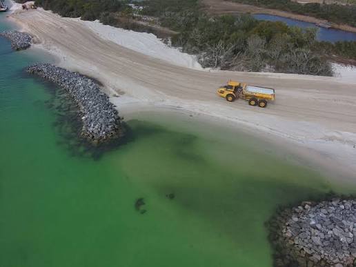
The Pensacola Bay Living Shoreline effort is the clearest case. Around Naval Air Station Pensacola partners have designed reefs, breakwaters, sediment placement, marsh, and seagrass to restore habitat and stabilize eroding shoreline. Audubon reported that the broader effort was designed around roughly 20,000 feet of limestone reefs and breakwaters and about 200 acres of marsh and seagrass habitat, with $36 million invested across partners and work for eight local businesses. The Magazine Point project is explicitly intended to protect critical naval infrastructure as it restores coastal systems. Two decades earlier and a few miles east, Project GreenShores had already demonstrated the principle downtown, combining oyster reef, salt marsh, seagrass, and submerged breakwaters to reduce wave energy and stabilize shoreline.3, 4, 5, 6
That is more than a collection of co-benefits. Ecology, military readiness, storm protection, fisheries, specialized construction, and local economic activity are being produced by the same physical intervention. The lesson is not that every shoreline should be green rather than gray; living shorelines are site-specific and sometimes require substantial engineered components. The lesson is that infrastructure can be designed to perform across systems, and that a project becomes easier to value once we stop insisting that only one of those performances is real.
Follow the same logic inland
Beneath Interstate 110, the Hollice T. Williams project turns a familiar hierarchy inside out. The city is advancing a regional stormwater facility intended to mitigate flooding along the I-110 corridor, treat runoff before it reaches Pensacola Bay, and support a more biodiverse landscape, with a longer-term park vision adding recreation, cultural interpretation, and an effort to reconnect a neighborhood fragmented by the Interstate. The highway is not the only real infrastructure, with everything beneath it reduced to residual land. The residual land is being asked to do serious hydrologic, ecological, and civic work.7
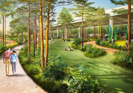
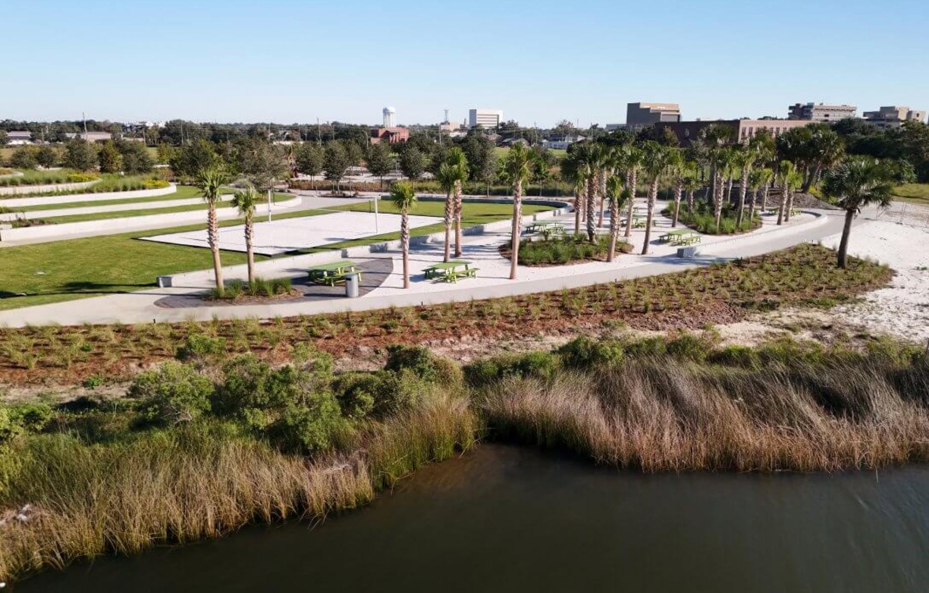
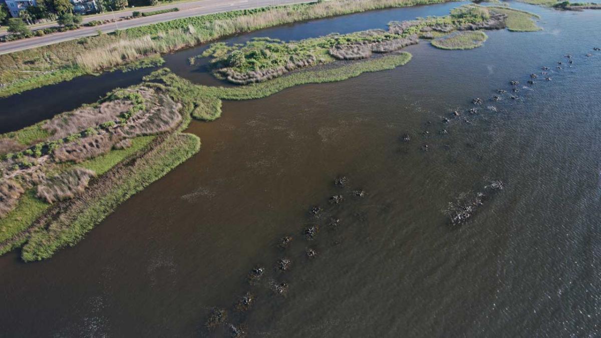
Two nearby projects extend the same reasoning in different directions. At Bruce Beach, a long-neglected waterfront site has become a recreational and educational destination that is also part of the city's vision for a continuous public waterfront—trails, play and learning features, cultural interpretation, kayak access, and landscape restoration occupying the same ground. Carpenter Creek moves from site to watershed: the completed Headwaters Park restored roughly 2.6 acres of wetlands and added paths, a boardwalk, a pollinator garden, drainage improvements, and flood protection, while the Pensacola and Perdido Bays Estuary Program advances a 2.5-mile restoration from I-110 to 12th Avenue. What looks from one vantage point like environmental restoration looks from another like flood infrastructure, neighborhood open space, recreation, and protection of Bayou Texar.8, 9
The proposed Bluffline adds a network-level proposition: a roughly 20-mile vision linking West Pensacola, downtown, the bayfront, and the University of West Florida through waterfront parks, protected trails, and transit connections. Because I cofounded Bluffline, I offer it here as an illustration of the planning logic rather than as independent evidence of outcomes. That logic is simple enough. The value of a park, trail, transit stop, restored shoreline, or neighborhood connection rises when it becomes part of a coherent system rather than an isolated amenity. Connectivity compounds value the way multiple functions do.10
The budget line is the next boundary
Pensacola's experience with urban forestry shows why this matters. A $1 million federal grant for the Pensacola Urban Forest Project was terminated in 2025. The city said it would continue planting trees with local tree-trust funds, but more slowly. The funding disappeared; the functions the trees were supposed to perform did not. Shade, rainfall interception, habitat, reduced solar gain, pedestrian comfort, and the visual quality of the street remained valuable even though no single budget line captured all of them.11
This is the structural weakness in first-cost accounting. The payer is concentrated while the returns are distributed. Transportation may receive a more walkable street, stormwater a little more interception, residents a cooler route, merchants a more comfortable public realm, buildings less solar exposure, and public health more opportunity for routine physical activity. None of those benefits, standing alone, may carry the investment. Together they can change its value materially. A capital process that counts only the benefit assigned to the sponsoring department will systematically underprice assets whose usefulness crosses administrative boundaries.
Existing instruments show that the ledger can be changed without inventing an entirely new system. Pensacola already charges a stormwater assessment on the principle that properties creating more stormwater impact should pay more. Other jurisdictions add credits for retaining or treating runoff on site; Washington, D.C., has gone further by making stormwater retention credits tradable. A bioswale, cistern, or permeable surface can therefore become not only a design feature but a recognized financial return.12, 13
FEMA's Community Rating System works on a similar principle at the community scale. Participating communities earn flood-insurance discounts by exceeding minimum floodplain-management standards, and open-space preservation and natural floodplain functions can earn credit. NOAA's Digital Coast program even offers training on mapping open space for CRS purposes. A greenway that keeps a floodplain undeveloped is not only a greenway; under the right framework, it can become a line in an insurance calculation that residents can see.14
Neither instrument solves the problem by itself. Credits are administratively demanding, CRS classes take time to improve, and both reward what is already measurable rather than automatically expanding what counts. But they demonstrate the underlying point: accounting systems are designed, and they can be redesigned. Better accounting does not require pretending that every attractive feature is infrastructure or assigning speculative dollar values to every tree and bench. It requires asking better questions before design narrows to first cost: Which systems does this project serve, and over what time horizon? Who receives the benefits, and who carries the maintenance burden? What future costs does it reduce? What options does it preserve that a single-purpose alternative would foreclose? Those questions belong in capital planning, not in after-the-fact narratives about co-benefits.
Arriving at the same place
There is a promising convergence between the New Urbanist insight embedded in the Charter and planetary health. New Urbanism begins with place—streets, blocks, buildings, public space, connectivity, human scale—and arrives at questions of health, adaptation, and resilience. Planetary health starts from human and ecological systems and arrives at the design of place.
The symmetry is useful. In Pensacola, the two approaches touch the same ground. A living shoreline, restored creek, shaded street, connected trail, or stormwater park is simultaneously a spatial intervention and an intervention in exposure, behavior, ecological function, and adaptive capacity.
There is room for much more deliberate cross-pollination. New Urbanists bring a mature vocabulary of physical form, street and block design, development practice, implementation, and the lived experience of building places. Planetary-health and public-health researchers bring exposure pathways, population vulnerability, ecosystem dependence, health metrics, and methods for measuring outcomes that urbanists often describe more intuitively. Neither field needs to absorb the other. But joint case studies, shared measures, interdisciplinary charrettes, and better project-evaluation tools could help both communities recognize value that currently disappears between disciplines. The most useful collaboration would not stop at conferences or conceptual frameworks; it would reach design review, capital budgeting, development finance, and post-occupancy measurement.
Who gets to decide?
Seen separately, Pensacola's projects are projects. Seen together, they begin to resemble a health and resilience system expressed through landscape and urban form—one that no single agency planned, owns, or evaluates. GreenShores and the NAS living shorelines work at the coast. Bruce Beach reconnects people to that coast. Hollice T. Williams turns highway-adjacent land into stormwater and civic infrastructure. Carpenter Creek repairs a watershed while opening public access. Bluffline proposes to connect these kinds of assets through human-scaled mobility.
This raises the question in the title, and the honest answer is that the decision is often difficult to locate. The Charter's 2024 amendment on participation is relevant here: the public has a right to participate in decisions that affect them. Yet infrastructure status is rarely assigned by one person in one room. It emerges from statutory eligibility, agency definitions, scoring criteria, grant cycles, accounting rules, maintenance responsibilities, benefit-cost models, and development pro formas. These instruments do not eliminate value judgments. They distribute them—sometimes so thoroughly that no one in the chain experiences having made a choice at all. Participation matters, but so does making the criteria themselves legible enough to see, test, and contest.
A useful first step is modest, and it is a change to the instrument rather than a new committee: require major capital proposals to state their cross-system returns and long-term maintenance obligations; bring health, ecological, financial, and design expertise in early enough to influence the design rather than narrate it afterward; and measure, after construction, whether the promised benefits actually appeared. That does not eliminate tradeoffs or remove judgment from the process. It makes the judgment more explicit—and therefore more open to public scrutiny, professional challenge, and revision.
The label “amenity” will still have a place. Not every pleasant feature is essential infrastructure, and not every nature-based project outperforms a conventional alternative. But the reverse is also true: many things dismissed as amenities are doing infrastructure work. The live oak, marsh, sidewalk, greenway, restored creek, and oyster reef can shape exposure, recovery, ecological function, local wealth, mobility, and civic life simultaneously.
That is not cause for despair. Every statute, scorecard, grant criterion, and accounting rule was written by someone and can be rewritten. The case for shade, marsh, and connected streets has largely been won on the merits. It has not yet been written into the forms.
References
1. Congress for the New Urbanism - Charter of the New Urbanism (1996), including the 2024 amendments.
2. James C. Scott - Seeing Like a State: How Certain Schemes to Improve the Human Condition Have Failed (Yale University Press, 1998), especially pp. 11-22.
3. Audubon - A Living Shoreline in Pensacola Creates Jobs and Protects People and Wildlife
4. NFWF - Pensacola Bay Living Shoreline Project: White Island Habitat Restoration
5. NOAA Office for Coastal Management - Living Shoreline at Magazine Point, NAS Pensacola
6. Florida DEP - Project GreenShores
7. City of Pensacola - Hollice T. Williams Stormwater Park
8. City of Pensacola - Bruce Beach Park Improvements
9. Florida DEP / PPBEP - Carpenter Creek Headwaters Park and Carpenter Creek Restoration Project
10. Bluffline - Pensacola's 20-mile multimodal corridor
11. WUWF - City of Pensacola loses $1 million Arbor Day Grant
12. City of Pensacola - Stormwater assessment
13. District of Columbia Department of Energy and Environment - Stormwater Retention Credit Trading Program
14. FEMA - National Flood Insurance Program Community Rating System; NOAA Digital Coast - training on mapping open space for CRS credit