- Who We Are
- What We Do
- Our Issues
- Our Projects
- Sprawl Retrofit
- Highways to Boulevards
- CNU/ITE Manual
- Health Districts
- The Project for Code Reform
- Lean Urbanism
- LEED for Neighborhood Development
- Missing Middle Housing
- Small-Scale Developers & Builders
- Emergency Response
- HUD HOPE VI
- Rainwater in Context
- Street Networks
- HUD Finance Reform
- Affordable Neighborhoods
- Autonomous Vehicles
- Legacy Projects
- Build Great Places
- Education & Trainings
- Charter Awards
- Annual Congress
- Athena Medals
- Resources
- Get Involved
- Support CNU
- Public Square


History and Context
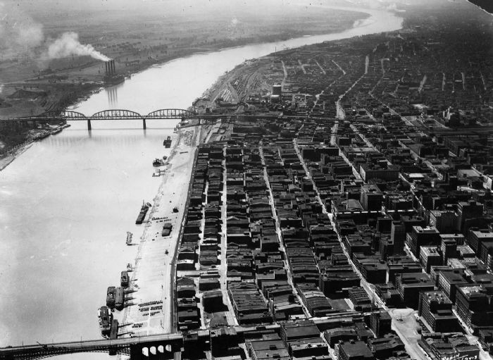
When I-70 divided the city of St. Louis from the Mississippi riverfront in 1964, it devastated the vitality of the downtown area and isolated one of the most iconic architectural treasures in the United States, the Gateway Arch, from the city. The neighborhood cleared first for the famous St. Louis Arch, and then the highway, was a historic architectural neighborhood which many compared to New Orleans in looks, music, and culture. According to the Missouri Department of Transportation (MoDOT) “the downtown lanes [of I-70] are one of the least traveled sections of interstate in the Saint Louis area. Currently the majority of approximately 70,000 vehicles per day in this section are traveling through Saint Louis to points west. With the rerouting of I-70 it is probable that that amount of traffic could be reduced by greater than 50%.”
A General Management Plan was completed by the National Park Service in 2009 and resulted in a design competition offered by the National Park Service calling for the “framing” of the Arch by reimagining its connections with the City of St. Louis, the Mississippi River, and Illinois, which will reinvigorate and reintroduce the Arch and Jefferson National Expansion Memorial back to the community of St. Louis. The NPS “prefers and strongly supports the removal of the Interstate highway."
Proposal
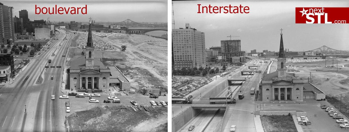
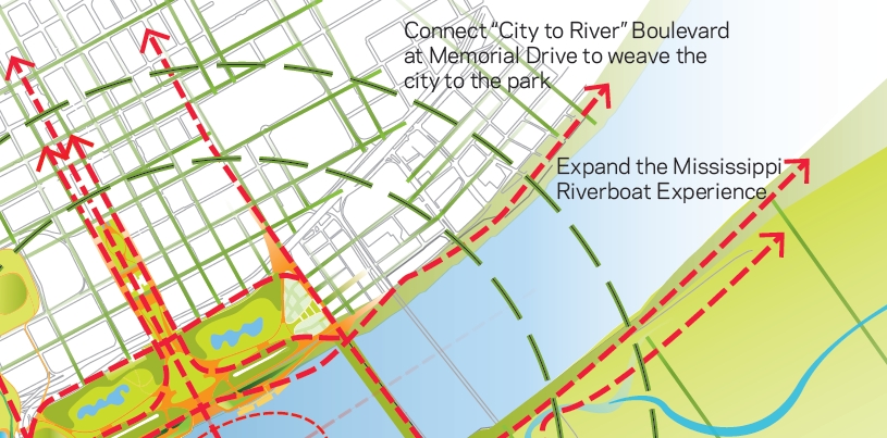
In February 2012, the St. Louis Development Corporation requested, “proposals for [a] downtown multimodal access study,” including a riverfront connectivity plan and specifically to "address the potential removal of the elevated sections of I-70 from north of Pine St. to O’Fallon St ." This request was a tremendous step toward revitalizing the downtown riverfront and converting I-70 to a boulevard. Acting as a city-wide voice, a group of volunteers formed the City to River movement in 2008 to improve the overall connectivity and beautification of the riverfront with downtown St. Louis. Their most high-profile effort is planning for the removal of I-70. With their guidance, efforts are underway to demonstrate the substantial benefits of converting the highway to an urban boulevard.
The St. Louis County Department of Highways and Traffic instituted a project to examine the South County Connector corridor to improve thoroughfare congestion, enhance interstate connectedness and increase mobility throughout south St. Louis County, the City of St. Louis, and central St. Louis County by increasing the connectivity of Interstates 44, 64, 55, and 170. The initial draft was evaluated by the Federal Highway Administration and through public hearings in 2012, and now the SCC project is currently in the editing stages of the Final Environmental Impact Statement after completing the Draft EIS in July of 2013.
Current Plans
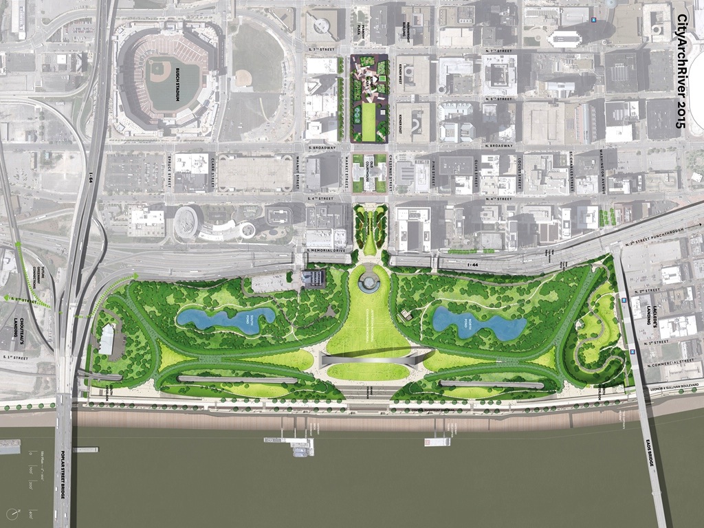
Despite the efforts of organizations in the city for the removal of the highway, officials fast-tracked a $380 million renovation of the Arch grounds in 2013 which includes a renovated "Park Over the Highway" enhancing pedestrian access and landscaping overtop of a depressed portion of I-70. Many advocating for the replacement of I-70 with an urban boulevard see this park, to be completed in 2015, as a half-measure, not completely reconnecting downtown Saint Louis with its waterfront or Arch grounds and a missed opportunity for the city.
At this time, the City and state DOT are no longer considering the boulevard option for I-70 through downtown in the short-term, suggesting it would not improve pedestrian or bike access as well as the "Park Over the Highway" purports to do. The boulevard option has been set on the back burner as a possible future option, and the new park runs along the Mississippi River, separated from Downtown St. Louis by the 180-foot-wide gulch of Highway I-70. The removal of a large parking garage next to the highway created new connections to the north to Laclede’s Landing, the oldest neighborhood in St. Louis, encouraging visitors to the Arch to experience the city’s other attractions.