- Who We Are
- What We Do
- Our Issues
- Our Projects
- Sprawl Retrofit
- Highways to Boulevards
- CNU/ITE Manual
- Health Districts
- The Project for Code Reform
- Lean Urbanism
- LEED for Neighborhood Development
- Missing Middle Housing
- Small-Scale Developers & Builders
- Emergency Response
- HUD HOPE VI
- Rainwater in Context
- Street Networks
- HUD Finance Reform
- Affordable Neighborhoods
- Autonomous Vehicles
- Legacy Projects
- Build Great Places
- Education & Trainings
- Charter Awards
- Annual Congress
- Athena Medals
- Resources
- Get Involved
- Support CNU
- Public Square


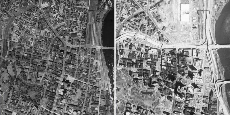
History and Context
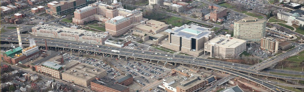
The ¾ mile elevated portion of Interstate 84 begins at Sisson Avenue and runs through the heart of downtown Hartford, Connecticut. Completed in 1965, it caused significant damage to the historic neighborhoods of Hartford, destroying historic architecture and breaking the walkable connections between adjacent communities and public spaces such as Asylum Hill and Frog Hill. It also destroyed the economic vitality of the community, and downtown growth was inhibited for decades. To this day, the imposing viaduct prevents pedestrians from utilizing the space underneath, as most of the area is dedicated to surface parking.
Originally built for 55,000 vehicles per day, the viaduct reached the endpoint of its 40-year lifespan in 2005. The City of Hartford was faced with the question: How do we address this piece of infrastructure which sustains roughly 175,000 vehicles per day, the state's most heavily trafficked? The Connecticut Department of Transportation (ConnDOT) originally proposed to invest $100 million into resurfacing, effectively increasing the viaduct's lifespan another 20 years. But stakeholders voiced their opposition, loudly, urging ConnDOT to change course.
Proposal
After securing federal funding, the City of Hartford hired Goody-Clancy to perform an alternatives study of the viaduct. The I-84 Viaduct Study, published in 2010, noted that while the viaduct is in need of immediate repairs, the roadway would need to be fully reconstructed or replaced within 10-15 years. Active citizens from Asylum Hill and other affected neighborhoods, with the support from then-Mayor Eddie Perez and the Connecticut Department of Transportation, joined together to form the Hub of Hartford Committee to represent and reinforce the removal of the Aetna Viaduct.
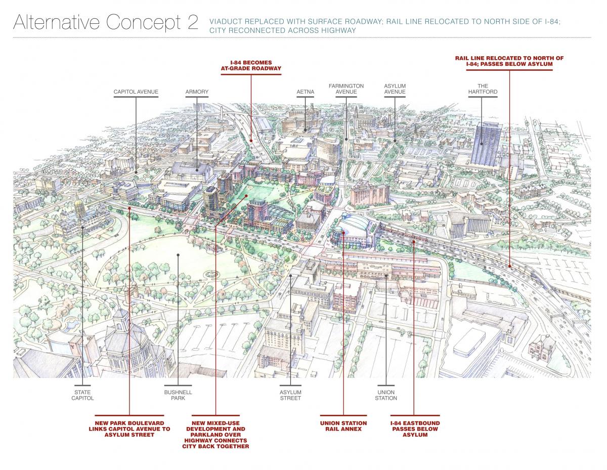
The real turning point in the campaign came from the study itself. In it, the Capitol Region of Council Governments (CRCOG) and city officials saw new opportunity in re-aligning existing train tracks north of the highway's path. Maintaining the current path of the tracks in the footprint of the highway would require an overpass, which are expansive to build and maintain. Re-aligning the tracks would take more coordination, but would not require the physically separating viaduct and be a more cost-effective alternative in the long term. Additionally, 15-20 acres of land would be made available for development and new, meaningful connections to downtown could be made.
Current Situation
Coordination remains crucial. Today, CRCOG is working closely with the Hub of Hartford and the City of Hartford to advocate for smart alternatives. The ConnDOT created five phases to decide the fate of the viaduct. Currently, it is nearing the end of the second data gathering phase and is preparing an engineering and environmental comprehensive study to look closely at the options followed by selecting a plan and construction. The boulevard alternative was eliminated from the study early on, as the massive daily traffic volumes were thought to require an inadequate and largely unattractive urban boulevard design. Due to lack of obvious funding, the project is predicted to remain in the planning stages: "Until we identify a funding strategy … we're expecting and planning to have to sustain the viaduct as it is." DOT Commissioner James Redeker explains.
In 2019, the city of Hartford completed a study to examine the benefits of lowering the viaduct and capping it. The city projects that the cap could reclaim as much as 3.6 million square feet for housing, office space and storefronts, which has the potential to generate an additional $38 million in state and city tax revenue. While the cap would reconnect part of Asylum Hill with downtown, the planned placement of on- and off-ramps to the depressed highway sever Myrtle Street's connection to downtown, currently the most direct route to the neighborhoods north of Asylum Hill. The plan also has a significant price tag of between $4.3 and $5.3 billion. For these reasons, along with the costs of simply repairing the highway ($1 billion per mile), the call to remove the highway and replace it with city streets remains strong. A formal decision is expected in 2020.
The state stopped the 2019 study to do a broader regional mobility study and now a new idea has emerged and is being presented to civic and business officials, neighborhood groups and others. The new plan is part of a regional planning effort called Hartford 400, initiated by the iQuilt project in Hartford.
The new plan would remove significant stretches of highway, including the I-84/I-91 and “mixmaster” interchanges, that carve up the city and separate downtown and its neighborhoods. This would free up more than 150 acres of land for potential redevelopment in Hartford and East Hartford and would also reconnect the city to the Connecticut River, creating untold opportunities for new waterfront development, which would be a game changer for Hartford. The preliminary cost estimate is $17 billion over a period of 15 years.
Get Involved
To get updates or contribute to this project, check out The I-84 Hartford Project.